Topics
Field Visit
Location and Extent
- Introduction to India and Brazil
- Indian - Location, Size and Extent
- Brazil - Location, Size and Extent
- Historical Background of India
- Historical Background of Brazil
- Difference Between Post-Independence Characteristics of India and Brazil
Physiography and Drainage
- Map Study: Physical Divisions of India
- Map Study: Physical Divisions of Brazil
- Physical Division of India> The Himalayas
- Physical Division of India > North Indian Plains
- Physical Division of India > The Peninsula
- Physical Division of India > The Coastal Plains
- Physical Division of India > The Island Group
- Physical Division of Brazil> The Highlands
- Physical Division of Brazil> The Great Escarpment
- Physical Division of Brazil> The Coasts
- Physical Division of Brazil> The Plains
- Physical Division of Brazil> Islands
- Comparative Study of the Ganga and Amazon River Basins
- Drainage of Brazil
- Drainage of India
Climate
- Map Study: Temperature and Rainfall Distribution (Brazil)
- Map Study: Temperature and Rainfall Overview (India)
- Temperature & Rainfall Graphs of Brazil
- Climate of Brazil
- Temperature & Rainfall Graphs of India
- Climate of India
Natural Vegetation and Wildlife
- Brazil: Physiography, Natural Vegetation and Wildlife
- Brazil Vegetation
- India Vegetation
- Brazil Wildlife
- India-Wildlife
Population
- Population of India
- Population in Brazil
- Population Composition of Brazil and India> Sex Ratio
- Population Composition of Brazil and India> Age and Sex Pyramid
- Population Composition of Brazil and India> Population Growth Rate
- Population Composition of Brazil and India> Life Expectancy
- Population Composition of Brazil and India> Literacy Rate
Human Settlements
Economy and Occupations
Tourism, Transport and Communication
- Map Study: Tourism Trends in Brazil and India
- Tourism in Brazil
- Tourism in India
- Brazil Transport
- India Transport
- Communication in Brazil
- Communication in India
Geography - Physical Divisions of India
Identification of Physical divisions
- Identification of Physical Divisions
Geography - North Indian Mountains
Himalayas
Associated mountains
- Concept of Associated Mountains
Geography - North Indian Plain Region
Deserts
- Desert
Western Plains
- Concept of Western Plains
Central Plains
- Concept on Central Plains
Delta region
- Concept of Delta Region
Eastern Plains
- Concept of Eastern Plains
Geography - Peninsular Plateau Region
Chhotta Nagpur Plateau
- Concept for Chhotta Nagpur Plateau
Malwa Plateau
- Concept on Malwa Plateau
Maharashtra Plateau
- Concept for Maharashtra Plateau
Karnataka Plateau
- Concept for Karnataka Plateau
Telangana Plateau
- Concept for Telangana Plateau
Geography - Western Ghats and Eastern Ghats
Eastern Ghats
- Concept on Eastern Ghats
Sahyadries
- Concept on Sahyadries
Geography - Coastal Region
- Geography - Coastal Region
Eastern coastal plain
- Coastal Region - Eastern Coastal Plain
- Concept for Western Coastal Plain
Western coastal plain
- Concept for Western Coastal Plain
Geography - Indian Islands
- Geography - Indian Islands
Eastern Islands
- Indian Islands - Eastern Islands
Western Islands
- Indian Islands - Western Islands
Geography - Practical 1
Cartography
- Concept on Cartography
Geography - Practical 2
Two dimensional diagrams
- Two Dimensional Shapes
One dimensional diagrams
- Concept on One Dimensional Diagrams
Economics - Introduction of an Economy
Introduction of an Economy
- Types of Economy
- Main Features of Economy
Economics - Basic problems of an economy solution
Solutions
Problems
- Introduction of Basic Problems of an Economy
- Problems- for Whom to Produce
- Problem - How Much to Produce
- Problem - by Whom to Produce
Economics - Inflation
Introduction
Effects of inflation
- Effects of Inflation
Measures of Inflation
- Measures of Inflation
Causes of inflation
- Causes of Inflation
Economics - Public distribution system and consumer protection
- Measures of Inflation
Public Distribution system - meaning and explanation
- Public Distribution System - Meaning and Explanation
Introduction
- Introduction of Public Distribution System and Consumer Protection
Objectives of Public Distribution system
- Objectives of Public Distribution System
Remedial Measures
- Remedial Measures Public Distribution System and Consumer Protection
Consumer Protection
- Consumer Protection - Rights and Duties of Cunsumer, Food Adulteration
Drawbacks of Public Distribution system
- Drawbacks of Public Distribution System
Progress of Public Distribution system
- Progress of Public Distribution System
Notes
Population in Brazil:
|
Population Distribution in Brazil |

- Brazil is the most populous country in the South American continent. According to Census 2010, Brazil ranks fifth in the world with a population of around 19 crores. It is also the fifth largest country in the world in terms of land area. Brazil has 5.6% of the world's land area and 2.78% of the world's population. As a result, the population density is around 23 people per square kilometre.
- Brazil's population distribution is highly uneven. The majority of Brazilians have concentrated within 300 kilometres of the eastern coastal plain. As a result, agriculture and industry have thrived. As a result, there is a higher population density here.

Population density in Brazil
- The Amazon Basin's interior, on the other hand, is sparsely populated. Climate, heavy rainfall, inaccessibility, and dense forests are all obstacles to human settlement development here. As a result, settlements are limited to a few areas of the Amazon basin.
- The central and western parts of Brazil are less populated. Brazil's highlands have a moderate population density.
Example
Observe figures and answer the questions.
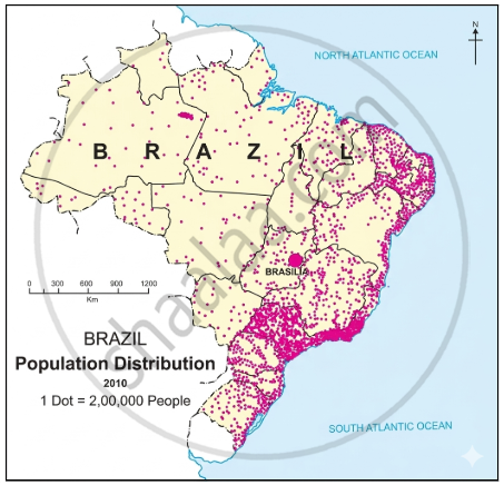
- In which area is population greatly concentrated?
- In which area is the distribution of population sparse?
- Prepare a note on factors responsible for the uneven distribution of population based on study of Brazil you have made so far.
- Identify the type of map showing distribution.
- The population is concentrated in Sao Paulo, Rio de Janeiro, and the southeastern coastal regions.
- The Amazon Basin in the northern part and the central and western parts of Brazil have a sparse distribution of population.
- The distribution of population in Brazil is uneven:
- There is sparse population in the Amazon Basin due to hot and humid climate, heavy rainfall, dense forests, inaccessibility.
- The population is low in the swampy areas of Pantanal.
- Low population is found in the central and western part of Brazil due to lack of minerals, low rainfall, hot and dry climatic conditions.
- The distribution of population is moderate in Brazilian Highlands.
- High population is found in the coastal regions and the southern part of Brazil. This is due to flat fertile land and abundant availability of minerals due to which agriculture, industries and trade have developed.
- The type of map showing the distribution of population is a dot map.
Maharashtra State Board: Class 10
Key Points: Population of Brazil
- Brazil’s population was 19 crores in 2010, ranking 5th globally.
- It has 5.6% of land and 2.78% of the world’s population; density is 23 persons/sq.km.
- Most people live near the eastern coast due to farming and industries.
- Amazon Basin is sparsely populated due to rainfall, forests, and inaccessibility.
- Central and western Brazil have low density; the highlands have a moderate population.
Related QuestionsVIEW ALL [12]
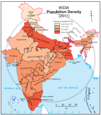
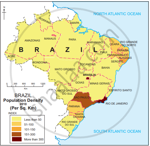
Study the indices of density maps of both the countries. What difference do you find? What conclusions can you draw?
|
India Population Density |
|
Population density in Brazil |