Topics
Field Visit
Location and Extent
- Introduction to India and Brazil
- Indian - Location, Size and Extent
- Brazil - Location, Size and Extent
- Historical Background of India
- Historical Background of Brazil
- Difference Between Post-Independence Characteristics of India and Brazil
Physiography and Drainage
- Map Study: Physical Divisions of India
- Map Study: Physical Divisions of Brazil
- Physical Division of India> The Himalayas
- Physical Division of India > North Indian Plains
- Physical Division of India > The Peninsula
- Physical Division of India > The Coastal Plains
- Physical Division of India > The Island Group
- Physical Division of Brazil> The Highlands
- Physical Division of Brazil> The Great Escarpment
- Physical Division of Brazil> The Coasts
- Physical Division of Brazil> The Plains
- Physical Division of Brazil> Islands
- Comparative Study of the Ganga and Amazon River Basins
- Drainage of Brazil
- Drainage of India
Climate
- Map Study: Temperature and Rainfall Distribution (Brazil)
- Map Study: Temperature and Rainfall Overview (India)
- Temperature & Rainfall Graphs of Brazil
- Climate of Brazil
- Temperature & Rainfall Graphs of India
- Climate of India
Natural Vegetation and Wildlife
- Brazil: Physiography, Natural Vegetation and Wildlife
- Brazil Vegetation
- India Vegetation
- Brazil Wildlife
- India-Wildlife
Population
- Population of India
- Population in Brazil
- Population Composition of Brazil and India> Sex Ratio
- Population Composition of Brazil and India> Age and Sex Pyramid
- Population Composition of Brazil and India> Population Growth Rate
- Population Composition of Brazil and India> Life Expectancy
- Population Composition of Brazil and India> Literacy Rate
Human Settlements
Economy and Occupations
Tourism, Transport and Communication
- Map Study: Tourism Trends in Brazil and India
- Tourism in Brazil
- Tourism in India
- Brazil Transport
- India Transport
- Communication in Brazil
- Communication in India
Geography - Physical Divisions of India
Identification of Physical divisions
- Identification of Physical Divisions
Geography - North Indian Mountains
Himalayas
Associated mountains
- Concept of Associated Mountains
Geography - North Indian Plain Region
Deserts
- Desert
Western Plains
- Concept of Western Plains
Central Plains
- Concept on Central Plains
Delta region
- Concept of Delta Region
Eastern Plains
- Concept of Eastern Plains
Geography - Peninsular Plateau Region
Chhotta Nagpur Plateau
- Concept for Chhotta Nagpur Plateau
Malwa Plateau
- Concept on Malwa Plateau
Maharashtra Plateau
- Concept for Maharashtra Plateau
Karnataka Plateau
- Concept for Karnataka Plateau
Telangana Plateau
- Concept for Telangana Plateau
Geography - Western Ghats and Eastern Ghats
Eastern Ghats
- Concept on Eastern Ghats
Sahyadries
- Concept on Sahyadries
Geography - Coastal Region
- Geography - Coastal Region
Eastern coastal plain
- Coastal Region - Eastern Coastal Plain
- Concept for Western Coastal Plain
Western coastal plain
- Concept for Western Coastal Plain
Geography - Indian Islands
- Geography - Indian Islands
Eastern Islands
- Indian Islands - Eastern Islands
Western Islands
- Indian Islands - Western Islands
Geography - Practical 1
Cartography
- Concept on Cartography
Geography - Practical 2
Two dimensional diagrams
- Two Dimensional Shapes
One dimensional diagrams
- Concept on One Dimensional Diagrams
Economics - Introduction of an Economy
Introduction of an Economy
- Types of Economy
- Main Features of Economy
Economics - Basic problems of an economy solution
Solutions
Problems
- Introduction of Basic Problems of an Economy
- Problems- for Whom to Produce
- Problem - How Much to Produce
- Problem - by Whom to Produce
Economics - Inflation
Introduction
Effects of inflation
- Effects of Inflation
Measures of Inflation
- Measures of Inflation
Causes of inflation
- Causes of Inflation
Economics - Public distribution system and consumer protection
- Measures of Inflation
Public Distribution system - meaning and explanation
- Public Distribution System - Meaning and Explanation
Introduction
- Introduction of Public Distribution System and Consumer Protection
Objectives of Public Distribution system
- Objectives of Public Distribution System
Remedial Measures
- Remedial Measures Public Distribution System and Consumer Protection
Consumer Protection
- Consumer Protection - Rights and Duties of Cunsumer, Food Adulteration
Drawbacks of Public Distribution system
- Drawbacks of Public Distribution System
Progress of Public Distribution system
- Progress of Public Distribution System
Notes
Climate of Brazil:
|
Annual Average Precipitation and Temperature of Brazil |

- Brazil experiences a wide range of climatic variations due to its vast latitudinal extent.
- For example, near the equator, the climate is hot, whereas, near the Tropic of Capricorn, the climate is temperate.
A) Temperature:
- When it comes to temperatures in Brazil, the northern part of the country is hot, while the southern part is cooler. This pattern shows seasonal variations.
- Temperature varies a little near the equator on the Brazilian coast. Temperature differences in Brazil's coastal regions near the equator are negligible.
- The majority of this country is in the tropical zone. The equator passes through the country's northern region. This area has a higher temperature.
- The average temperature in the Amazon valley ranges between 25°−28°C. The Highlands has a cooler climate. The coast has a mild and humid climate due to its proximity to the sea.
B) Pressure Condition:
- In the Brazil's coastal regions near the equator, the winds blow vertically. Similarly, the convergence zone of the trade wind is weak here. As a result, cyclones do not form. That is why tropical cyclones rarely visit the coasts of Brazil.
C) Rainfall and Snowfall:
- Rainfall in Brazil is caused by the South-East Trade Winds and the North-East Trade Winds.
- The Brazilian highlands extend all the way up to the northern coast. The escarpments act as a barrier to the winds blowing from the sea, resulting in orographic rainfall in the coastal region.Beyond the highlands, the impact of these winds reduces. As a result, there is little rain. This area is in the rainshadow. This area is known as the 'Drought Quadrilateral'.
- The Amazon valley receives approximately 2000 mm of rainfall, whereas the northeastern coast receives 1000 to 1200 mm.
- Brazil is a tropical country. It normally does not receive snowfall. But in exceptional conditions, southern polar air masses reach the southern part of Brazil. This causes snowfall here. Snowfall has been recorded in 1879, 1957, and 1985.
Example
Study the graphs given in Fig and answer the following questions.
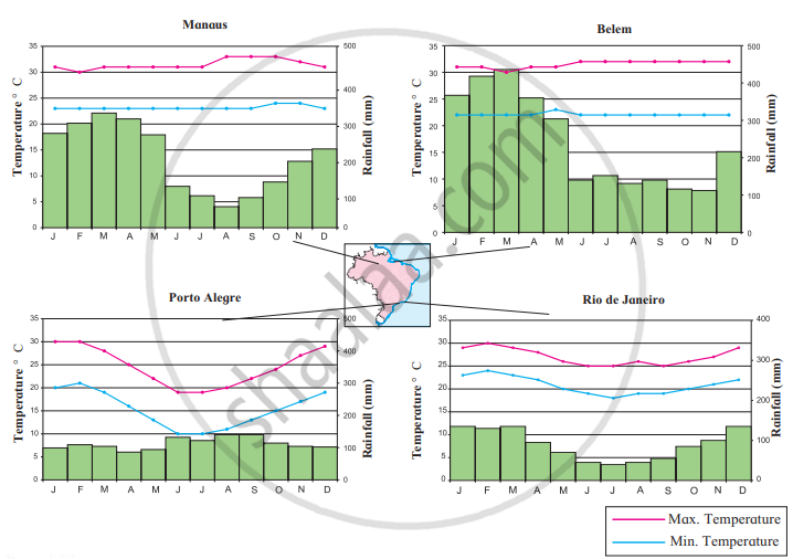
- In which month is the highest temperature found in all four cities?
- In which month does it rain the most in the given cities?
- When does Brazil have its rainy season?
- Which city has the maximum range of temperature? How much is it?
- What type of climate will be found in Rio De Janerio?
- The highest temperature months per city:
- Manaus: August - October
- Belem: June - December
- Porto Alegre: January - February
- Rio de Janeiro: February
- The highest rainfall per city:
- Manaus: March
- Belem: March
- Porto Alegre: August - September
- Rio de Janeiro: January, February and December
- Brazil has its rainy season from December to April.
- Porto Alegre has the highest range of temperature, ranging from 30 to 140 degrees Celsius.
- Rio de Janeiro has a tropical savannah climate.
Example
Study the given figures and answer the following questions:

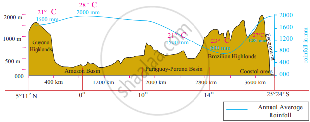
- Considering the isotherms of Brazil, what is the average range of temperature in Brazil?
- In which area does it rain more?
- From which directions are winds flowing towards Brazil?
- What could be the reason behind that?
- What could be the obstruction in the way of these winds?
- Which type of rainfall will occur because of these winds?
- Correlate these winds and rainfall.
- In which part of Brazil are the average temperatures low?
- Identify the rain-shadow area in Brazil. Describe its climatic characteristics.
- In which region do you find a higher temperature?
- Considering the latitudinal extent of Brazil, where will you find a temperate climate in Brazil?
- Describe the winds blowing between 0° to 5° N and S zones.
- Which method has been used to show distribution in this map?
- Considering the isotherms of Brazil, the average range of temperature of Brazil is 10°C (28°C-18°C).
- It rains more in the northern and central part of Brazil. E.g., Amazon Valley.
- The winds are blowing from North East and South East directions.
- These are permanent trade winds which blow from the high-pressure belt to the equatorial low-pressure belt. Brazil, being in the tropical zone, creates a low-pressure area, and winds start blowing from the ocean to the land.
- The Escarpment acts as an obstruction in the way of the South East Trade Winds coming from the sea.
- Orographic rainfall will occur because of these winds.
- The escarpments act as an obstruction to the winds blowing from the sea and cause an orographic type of rainfall in the coastal region. Beyond the Highlands, the effect of these winds gets reduced. As a result, the rainfall is minimal.
- The average temperatures are low in the southern part of Brazil.
- The north-eastern part of the Brazilian highlands is a rain shadow region. Beyond the highlands, the effect of the South East Trade Winds gets reduced and the rainfall is minimal. Also, the temperature here is quite high. This rain shadow region is referred to as the ‘Drought Quadrilateral’.
- The northern part of Brazil has higher temperatures.
- The southern part of Brazil, lying below 23° 30' S latitude (Tropic of Capricorn), experiences a temperate climate.
- The winds blowing between 0° and 5° N and S zones move vertically, leading to convectional rain. The North East and South East Trade winds are very weak in this region.
- The Isopleth method has been used to show the distribution in this map.
Example
Considering the location, the extent of Brazil and India, look for the differences in the elements of climate like temperature and rainfall as per direction. Write a short note on it.
The climatic conditions of India and Brazil are greatly influenced by their coastline.
- India receives its rainfall from Southwest monsoon winds whereas Brazil gets its rainfall from Southeast and Northeast trade winds.
- India experiences a tropical and subtropical climate. This is because the Tropic of Cancer passes through the centre of India.
- Northern Brazil has a hot and humid climate while Southern Brazil experiences a temperate climate. The Equator passes through the north of Brazil and the Tropic of Capricorn passes through southern Brazil.
Maharashtra State Board: Class 10
Key Points: Climate of Brazil
- Brazil's vast latitudinal extent causes climatic variation—hot near the Equator, cooler near the Tropic of Capricorn.
- South-East and North-East Trade Winds bring rainfall; orographic rainfall occurs along the coastal escarpments.
- The Drought Quadrilateral lies in the rain-shadow region beyond the highlands, receiving less rainfall.
- Temperature is higher in the north (Amazon region: 25–28°C), and cooler in the highlands and south.
- Tropical cyclones are rare due to weak trade wind convergence and vertical air movement near the equator.
Related QuestionsVIEW ALL [23]
Considering the various factors affecting Brazil’s climate, complete the adjoining table.
| Regions | Climatic characteristics |
| Amazon Valley | |
| Highlands | |
| Pantanal | |
| Northern Coastal region | |
| Southern Coastal region | |
| Southernmost region of Brazil |
