Advertisements
Chapters
1: Locational Setting of India
2: Geological Evolution and Structure
3: Relief
4: Drainage
▶ 5: Climate
6: Natural Vegetation
UNIT 2 : POPULATION AND HUMAN SETTLEMENTS
7: Population
8: Migration Trends
9: Demographic Attributes
10: Rural Settlements
11: Urban Settlements
UNIT 3 : RESOURCES OF INDIA AND THEIR UTILISATION
12: Environmental Management and Land use Pattern
13: Water Resources and Types of Irrigation
14: Agriculture
15: Fisheries
16: Mineral and Power Resources
UNIT 4 : INFRASTRUCTURAL RESOURCES
17: Transport and Communication
18: Industries
19: Tourism Industry
UNIT 5 : REGIONAL ECONOMIC DEVELOPMENT
20: Regional Economic Development: Case Studies
PART 2 - Practical Work and Project Report
1: Scales
2: Representation of Relief
3: Study and Interpretation of Topographical Maps
4: Geographical Information System (GIS)
5: Remote Sensing
6: Surveying
7: Project Work
![D. R. Khullar solutions for Geography [English] Class 12 ISC chapter 5 - Climate - Shaalaa.com](/images/geography-english-class-12-isc_6:9fc85d81f6f64f1b9b714d2c00427833.jpg "D. R. Khullar solutions for Geography [English] Class 12 ISC chapter 5 - Climate")
Advertisements
Solutions for Chapter 5: Climate
Below listed, you can find solutions for Chapter 5 of CISCE D. R. Khullar for Geography [English] Class 12 ISC.
D. R. Khullar solutions for Geography [English] Class 12 ISC 5 Climate EXERCISES [Pages 90 - 96]
SHORT-ANSWER TYPE Q!JESTIONS
What are the three important factors which influence the mechanism of Indian weather?
How does the westerly jet help in bringing the western disturbances to the Indian sub-continent during winter?
What is the Inter-Tropical Convergence Zone?
How does the Inter-Tropical Convergence Zone (ITCZ) attract the southwest monsoon?
What are ‘Western Disturbances’?
In what parts do Western Disturbances cause precipitation during winter in India?
What is the use of western disturbance rainfall?
What is a loo?
What is meant by ‘bursting of monsoon’?
Give two important characteristics of the summer monsoon rainfall in India.
Name the coldest place in India.
Name the hottest place in India.
Name the rainiest parts of India. Why is it so?
Name the driest parts of India. Why is it so?
What is ‘Coefficient of Variation’?
What is the effect of Coefficient of Variation?
Why is the co-efficient of variation of annual rainfall low on the west coast of India and high in Kachchh and Gujarat?
Give the Reason:
Mawsynram receives the highest average annual rainfall.
Give reasons why:
South-west monsoons are generally interspersed with spells of dry weather.
Give reasons why:
The rainfall in a year at Jaisalmer rarely exceeds 12 centimetres.
Give reasons for the following:
When the Malabar Coast is receiving heavy rainfall in July, the Tamil Nadu coast is comparatively dry.
Give reasons why:
The coastal areas of India do not experience significant variation in temperature between summer and winter months.
Give the Reason:
Mawsynram receives the highest average annual rainfall.
Give a reason why:
The annual rainfall in Rajasthan is less than 25 cms.
Give a reason why:
Chennai has a low variation between summer and winter temperatures.
Give a reason why:
The Monsoons are said to ‘burst’ by the end of May and the beginning of June.
Study the given maps A and B in Fig. and answer the following questions:
- Pressure and wind conditions of which months are represented by maps ‘A’ and ‘B’ respectively.
- What difference do you find in pressure and winds in these two maps?
- State the cause of these differences.

Study the climatic graphs of six places in India given in Fig. and answer the following questions.
- Which one of the given graphs depicts the climatic data of Chennai?
- Give three reasons with reference to temperature, amount of rainfall and rainfall regime.

Study the temperature and rainfall graph given in Fig. and answer the following questions.
- Which place is represented by this graph?
- Why annual range of temperature is large?
- Why rainfall is meagre?

Study the temperature and rainfall graph given in Fig. and answer the following questions:
- Which place is represented by this graph.
- What is the cause of sudden fall of temperature in July even though it is a summer month?
- What is the cause of rainfall from December to March?

Study the temperature and rainfall map given in Fig. and answer the following questions:
- Name the place for which this graph shows the climatic data.
- The annual range of temperature is low and the temperature falls in June/July.
- The temperature remains stable from July to September and rises in October.
- The rainfall suddenly starts in June and continues up to September.

Study the temperature and rainfall graph given in Fig. and answer the following questions:
- The graph shows data of which place?
- Why temperature is below freezing point in winters?
- Why this place receives meagre rainfall?

Describe briefly the main causes of droughts in India.
How much area and population is affected by droughts in India?
Write a short note on Drought Prone Areas Programme in India.
“Droughts are most frequent in areas of marginal rainfall and high variability of rainfall.” Illustrate the statement with suitable examples.
Discuss the flood problem in the Ganga basin.
Discuss the flood problem in the Brahmaputra valley.
LONG-ANSWER TYPE QUESTIONS
Notwithstanding the broad climatic unity, the climate of India has many regional variations. Elaborate on this statement, giving suitable examples.
Give two important characteristics of the summer monsoon rainfall in India.
Significance of summer monsoon rainfall in the agricultural economy of the country.
Discuss in brief the mechanism of Indian weather with special reference to jet streams.
Describe the distribution of temperature in India during summer and winter season.
Give an account of the distribution of annual rainfall in India.
Explain How is distribution of annual rainfall in related to the relief of the country? with examples.
“Monsoons exercise an all-embracing and unifying influence on the weather conditions of India.” Elaborate this statement.
“Complete reversal of direction of winds with the change of season is the chief characteristic of the Indian Monsoon”. Discuss the statement.
“Rainfall in India is orographic in nature”. Give five examples with reference to the distribution of rainfall and the effect of relief of on its distribution.
Describe briefly the main causes of droughts in India.
Discuss the effects of droughts in India.
Mention the areas which suffer from droughts frequently.
Write an account of the flood-affected areas in India.
Explain why floods are not as frequent in South India as they are in North India.
Write a brief account of Flood Control Programmes in India.
Write a brief account of Flood Control Policy in India.
Write a geographical essay on Flood Forecasting in India.
“Of all the natural calamities, droughts and floods have affected the Indian economy the most.” Illustrate this statement.
D. R. Khullar solutions for Geography [English] Class 12 ISC 5 Climate Map Work [Page 96]
Mark and label the following on an outline map of India:
A place recording the lowest temperature in India.
[Hint: Dras or Kargil in J&K]
On the outline map of India, locate and label the following:
Shade a region of dense population south of the Tropic of Cancer.
Mark and label the following on an outline map of India:
A place receiving the highest amount of rainfall.
[Hint: Mawsynram in Meghalaya]
Mark and label the following on an outline map of India:
An important area receiving rainfall from the Western Disturbances.
[Hints: North-West India]
Mark and label the following on an outline map of India:
Position of jet stream in summer and winter.
Mark and label the following on an outline map of India:
Two areas receiving annual rainfall below 20 cm.
[Hint: Western extremity of Rajasthan and the region in the north-east of Ladakh range]
Show the following on an outline map of India:
- Drought prone areas.
- Flood affected areas.
D. R. Khullar solutions for Geography [English] Class 12 ISC 5 Climate Examination Corner [Pages 96 - 102]
SHORT-ANSWER TYPE QUESTIONS
What is the Inter-Tropical Convergence Zone?
Name the winds formed by the northward movement of the ITCZ.
Distinguish between ‘Burst of Monsoon’ and ‘Break of Monsoon’.
Explain any two climatic changes that take place in and around the Indian sub-continent that are responsible for the arrival of the south-west-monsoons.
Explain why does rainfall decrease eastwards in Peninsular India.
Explain why does rainfall decrease westwards in the Northern Plains.
Explain with two examples the role played by mountain ranges in the distribution of rainfall in India during the south-west monsoon period.
Study the climatic data provided in the table below for two places located in India.
| Location | Months | J | F | M | A | M | J | J | A | S | O | N | D |
| A | Mean Monthly temp. in °C | 12 | 17 | 26 | 32 | 35 | 39 | 34 | 28 | 25 | 24 | 21 | 20 |
| Mean Monthly rainfall (mm) | 10 | 23 | 18 | 15 | 23 | 231 | 381 | 363 | 195 | 56 | 13 | 5 | |
| B | Mean Monthly temp. in °C | 24 | 24 | 26 | 28 | 30 | 30 | 27 | 27 | 27 | 28 | 27 | 26 |
| Mean Monthly rainfall (mm) | 3 | 3 | 3 | 3 | 18 | 485 | 617 | 340 | 264 | 64 | 13 | 3 |
- Name the type of climate experienced by each place.
- Describe the main features of the climatic type named above as experienced in India.
- Which one of the places is inland and which one is coastal in location? How did you find out with the help of the data?
- Why does the Tamil Coast receive rainfall during winters.
Study the climatic data of two cities in India given below and answer the following questions.
| Cities | T/R | J | F | M | A | M | J | J | A | S | O | N | D |
| A | T | 14 | 17 | 23 | 29 | 34 | 35 | 31 | 30 | 29 | 21 | 20 | 15 |
| R | 25 | 21 | 16 | 10 | 10 | 68 | 186 | 170 | 125 | 14 | 2 | 9 | |
| B | T | 25 | 26 | 28 | 31 | 33 | 33 | 31 | 31 | 30 | 28 | 26 | 25 |
| R | 4 | 13 | 13 | 18 | 38 | 45 | 87 | 113 | 119 | 306 | 350 | 135 |
(T = Mean monthly Temperature °C; R = Average monthly Rainfall in millimetres)
- Amount for the difference in the range of temperature for the two cities.
- In which season does each city receive the maximum rainfall? Give reasons for your answer.
- Suggest an area where you think each city is located.
Study the climatic data of two cities in India given below and answer the following questions.
| Cities | T/R | J | F | M | A | M | J | J | A | S | O | N | D |
| A | T | 24 | 24 | 26 | 28 | 30 | 29 | 27 | 27 | 27 | 28 | 27 | 25 |
| R | 4 | 2 | 2 | 2 | 18 | 465 | 613 | 329 | 286 | 65 | 18 | 2 | |
| B | T | 25 | 26 | 28 | 31 | 33 | 33 | 31 | 31 | 30 | 28 | 26 | 25 |
| R | 4 | 13 | 13 | 18 | 38 | 45 | 87 | 113 | 119 | 306 | 350 | 135 |
(T = Mean monthly Temperature in °C; R = Average monthly Rainfall in millimetres)
- Account for the difference in the rainfall regimes of the two cities.
- Why is the temperature lower during the months of July-September for city A and December-January for city B?
Explain why the northwestern part of India receives rainfall during winters.
Name two types of cyclonic systems that affect the Indian sub-continent, and two areas that receive rainfall from these systems.
Name two types of cyclonic systems that affect the Indian sub-continent, and two areas that receive rainfall from these systems.
Name the seasons when they are active.
Name two states/areas in India that receive rainfall from tropical cyclones.
Name two states/areas in India that receive rain from temperate depressions.
What are ‘Western Disturbances’?
How do western disturbances influence the climate of India?
Why do some parts of India receive rainfall in hot, dry season? Name two states where such rainfall occurs.
Mention the areas which suffer from droughts frequently.
Floods and droughts occur regularly in India. Discuss any two measures each undertaken to solve these climatic hazards.
Briefly discuss the role of El Nino in the Indian climate.
What is meant by Break in Monsoons?
Why does Break in Monsoons occur?
Study the Temperature-Rainfall graph of station X below and answer the questions that follow:

- Is the location of station X Inland or coastal? Give a reason for your answer.
- Which branch of the South West Monsoon brings, rain from the month of June to September?
In the diagram given below, A represents the path of an upper atmospheric air movement in the cold weather season.
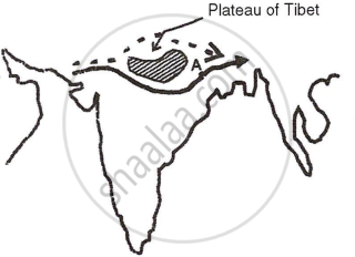
- Name A.
- Explain how A influences the weather of India during winter season.
State any two ways in which the Himalayas affect the Indian climate.
LONG-ANSWER TYPE QUESTIONS
Briefly describe the conditions of temperature, wind direction and rainfall over south India during the cool dry season.
Mention two reasons for the ‘break’ in monsoons.
Name two types of cyclonic systems that affect the Indian sub-continent, and two areas that receive rainfall from these systems.
Name the seasons when they are active.
Study the climatic data provided in the table below for a city A in India and answer the questions that follow:
| City | TIR | J | F | M | A | M | J | J | A | S | O | N | D |
| A | T | 25 | 26 | 28 | 31 | 33 | 33 | 31 | 31 | 30 | 28 | 26 | 25 |
| R | 4 | 13 | 13 | 18 | 38 | 45 | 87 | 113 | 119 | 306 | 350 | 135 |
T = Mean monthly temperature in degree Celsius (°C).
R = Average monthly rainfall in millimetres (mm).
- Account for the maximum rainfall in the months of October-November.
- Account for the low rainfall in city A during the months of June to September.
Explain how the following factor affect India’s climate:
Southern Oscillation
Explain how the following factor affect India’s climate:
Northern Mountain Ranges
Study the climatic data provided in the table below for a city A in India and answer the questions that follow:
| City | T/R | J | F | M | A | M | J | J | A | S | O | N | D |
| A | T | 20 | 23 | 26 | 32 | 35 | 39 | 34 | 28 | 25 | 28 | 24 | 21 |
| R | 14 | 23 | 27 | 42 | 121 | 231 | 300 | 306 | 289 | 160 | 34 | 5 |
T = Mean monthly temperature in degree Celsius (°C).
R = Average monthly rainfall in millimeters (mm).
- Mention two main features of the climate experienced by station A.
- Calculate the annual rainfall for station A.
In the Brahmaputra river basin, floods are almost an annual feature. Give two reasons to explain why.
Study the climatic graph of station A given below and answer the questions that follow:

- Give a reason as to why extreme low temperature is indicated for station A.
- Name the month when the highest amount of rainfall is received.
Give two reasons as to why Western Rajasthan is a desert.
State the climatic conditions of the tropical evergreen forests in India.
Explain the Jaisalmer receives very less rainfall annually.
Study the climatic data provided in the table below for a city A in India and answer the questions that follow:
| City | T/R | J | F | M | A | M | J | J | A | S | O | N | D |
| A | T | -8 | -3 | 2 | 7 | 15 | 18 | 17 | 12 | 10 | 5 | 0 | -7 |
| R | 10 | 8 | 8 | 5 | 5 | 5 | 13 | 13 | 8 | 5 | 0 | 5 |
T = Mean monthly temperature in degree Celsius (°C).
R = Average monthly rainfall in millimeters (mm).
- What is the cause of low rainfall in station A?
- Calculate the range of temperature of this station.
Study the temperature and rainfall graph of station X given below and answer the questions that follow:

- Is the location of station X inland or coastal?
- What is the cause of a sudden fall of temperature in July, even though it is a summer month?
- Mention one main feature of the climate experienced by the station X.
Explain, giving any two reasons, why the deltas of the river Mahanadi suffer from occasional floods.
MAP WORK
Mark and label the following on an outline map of India:
Shade one area where it rains during the hot, dry season and write the local name of the rain.
Mark and label the following on an outline map of India:
Write LP over the area having very low pressure during Hot, Dry Season.
Mark and label the following on an outline map of India:
Write ‘LP’ over an area of low pressure during the winter season.
Mark and label the following on an outline map of India:
Print HP over an area of high pressure in winter.
Mark and label the following on an outline map of India:
Print ‘HAR’ over an area experiencing a high annual range of temperature.
Mark and label the following on an outline map of India:
The ranges which receive the heaviest rainfall.
[Hint: Western Ghats and Meghalaya plateau]
Mark and label the following on an outline map of India:
With arrows, show the direction of the winds over the Ganga plain in the winter season.
Mark and label the following on an outline map of India:
Mark the Aravali Hills and show by arrow the direction of South-west Monsoons in relation to this range.
Mark and label the following on an outline map of India:
Shade an area which receives rain from the tropical cyclones in the hot, wet season.
Mark and label the following on an outline map of India:
Shade and label a drought-prone area in Western India.
Mark and label the following on an outline map of India:
Shade an area prone to extreme drought.
Mark and label the following on an outline map of India:
Shade and name one area prone to floods.
Mark and label the following on an outline map of India:
Shade and name the state which is the first to experience the south-west monsoon.
Solutions for 5: Climate
D. R. Khullar solutions for Geography [English] Class 12 ISC chapter 5 - Climate
Shaalaa.com has the CISCE Mathematics Geography [English] Class 12 ISC CISCE solutions in a manner that help students grasp basic concepts better and faster. The detailed, step-by-step solutions will help you understand the concepts better and clarify any confusion. D. R. Khullar solutions for Mathematics Geography [English] Class 12 ISC CISCE 5 (Climate) include all questions with answers and detailed explanations. This will clear students' doubts about questions and improve their application skills while preparing for board exams.
Further, we at Shaalaa.com provide such solutions so students can prepare for written exams. D. R. Khullar textbook solutions can be a core help for self-study and provide excellent self-help guidance for students.
Concepts covered in Geography [English] Class 12 ISC chapter 5 Climate are Overview of Climate, Factors Affecting India's Weather and Climate, The Concept of Monsoon, Mechanism of Monsoon, Indian Monsoonal Regime, The Rhythm of Seasons, Annual Rainfall, Incidence of Drought and Floods, Temperature and Rainfall Graphs.
Using D. R. Khullar Geography [English] Class 12 ISC solutions Climate exercise by students is an easy way to prepare for the exams, as they involve solutions arranged chapter-wise and also page-wise. The questions involved in D. R. Khullar Solutions are essential questions that can be asked in the final exam. Maximum CISCE Geography [English] Class 12 ISC students prefer D. R. Khullar Textbook Solutions to score more in exams.
Get the free view of Chapter 5, Climate Geography [English] Class 12 ISC additional questions for Mathematics Geography [English] Class 12 ISC CISCE, and you can use Shaalaa.com to keep it handy for your exam preparation.
