Advertisements
Chapters
1: Locational Setting of India
2: Geological Evolution and Structure
▶ 3: Relief
4: Drainage
5: Climate
6: Natural Vegetation
UNIT 2 : POPULATION AND HUMAN SETTLEMENTS
7: Population
8: Migration Trends
9: Demographic Attributes
10: Rural Settlements
11: Urban Settlements
UNIT 3 : RESOURCES OF INDIA AND THEIR UTILISATION
12: Environmental Management and Land use Pattern
13: Water Resources and Types of Irrigation
14: Agriculture
15: Fisheries
16: Mineral and Power Resources
UNIT 4 : INFRASTRUCTURAL RESOURCES
17: Transport and Communication
18: Industries
19: Tourism Industry
UNIT 5 : REGIONAL ECONOMIC DEVELOPMENT
20: Regional Economic Development: Case Studies
PART 2 - Practical Work and Project Report
1: Scales
2: Representation of Relief
3: Study and Interpretation of Topographical Maps
4: Geographical Information System (GIS)
5: Remote Sensing
6: Surveying
7: Project Work
![D. R. Khullar solutions for Geography [English] Class 12 ISC chapter 3 - Relief - Shaalaa.com](/images/geography-english-class-12-isc_6:9fc85d81f6f64f1b9b714d2c00427833.jpg "D. R. Khullar solutions for Geography [English] Class 12 ISC chapter 3 - Relief")
Advertisements
Solutions for Chapter 3: Relief
Below listed, you can find solutions for Chapter 3 of CISCE D. R. Khullar for Geography [English] Class 12 ISC.
D. R. Khullar solutions for Geography [English] Class 12 ISC 3 Relief EXERCISES [Pages 37 - 39]
SHORT-ANSWER TYPE QUESTIONS
What is the bhabar?
Give two important characteristics of a bhabar belt.
Write a brief note on ‘tarai’.
What is doab?
Give five examples from the Indian sub-continent.
Write a short note on the Aravalis.
Give three differences between the Western and the Eastern Himalayas.
Distinguish between Bhangar and Khadar.
Distinguish between the East Coastal Plain and West Coastal Plain.
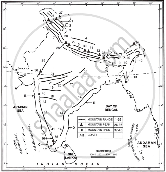
Write the names of the relief features marked in the map in Fig. below:
- 5, 24, 33, 36, 38 and E
- 13, 15, 27, 35, 38 and C
- 7, 25, 27, 29, 39 and C
- 6, 23, 32, 35, 37 and D
- 2, 17, 32, 36, 48 and A
- 1, 8, 16, 23, 37 and D.
The fig. below shows the section of the Himalayan Mountain Complex between the Tibetan Plateau and the Sindhu-Ganga Plains. Name the relief features marked on the diagram by letters A to H.

During which period of orogeny were the Himalayas formed?
Name three ranges that form part of the Himalayan chain.
LONG-ANSWER TYPE QUESTIONS
Name the relief divisions of India and describe any one of them in details.
Discuss the himalayas of regional divisions.
Discuss the Himalayas of three parallel ranges.
Discuss the Off-shoots of the Himalayas.
Divide the North Indian Plain into different regions and give a brief description of each.
Write a geographical essay on the Peninsular Plateau of India.
Name the oldest relief division of India.
How does peninsular plateau division differ from the northern mountains in composition and period of formation?
D. R. Khullar solutions for Geography [English] Class 12 ISC 3 Relief Map Work [Pages 39 - 41]
MOUNTAIN RANGES AND HILLS
Show the following relief feature on the outline map of India and write its name:
The southernmost range of the Himalayas.
[Hint: The Shiwalik Range]
Show the following relief feature on the outline map of India and write its name:
The Great Himalayas
Show the following relief feature on the outline map of India and write its name:
A mountain range located in the north of the Great Himalayas and having the highest peak of India.
[Hint: Karakoram Range]
Show the following relief feature on the outline map of India and write its name:
Mountain range in the north of the Tapi river and runing parallel to it.
[Hint: The Satpura Range]
Show the following relief feature on the outline map of India and write its name:
Mountain range in the north of the Tapi river and runing parallel to it.
[Hint: The Satpura Range]
Show the following relief feature on the outline map of India and write its name:
A mountain range in the north of the Narmada river and runnning parallel to it.
[Hint: The Vindhya Range]
Show the following relief feature on the outline map of India and write its name:
The oldest mountain range of India.
Show the following relief feature on the outline map of India and write its name:
A relict mountain range occupying the western flank of the Peninsular plateau.
Show the following relief feature on the outline map of India and write its name:
The oldest mountain range of India.
Show the following relief feature on the outline map of India and write its name:
A relict mountain range occupying the western flank of the Peninsular plateau.
Show the following relief feature on the outline map of India and write its name:
Hill near which Western Ghats and Eastern Ghats meet each other.
[Hint: Nilgiri]
Locate and label the following mountain ranges on the outline map of India.
- Himachal Himalaya
- Karakoram
- Ladakh
- Zaskar
- Pir Panjal
- Eastern Ghats
- Patkai Bum
- Naga hills
- Mizo hills
- Garo-Khasi and Jaintai hills
- Cardamom
- Mahadeo hills
- Maikal hills
- Rajmahal hills
MOUNTAIN PEAKS AND PASSES
Show the following relief feature on the outline map of India and write its name:
The highest mountain peak of the Indian subcontinent.
[Hint: Mount Everest, 8850 metres]
Show the following relief feature on the outline map of India and write its name:
The highest mountain peak of India.
[Hint: K2 or Godwin Austin in Karakoram, 8611 metres]
Show the following relief feature on the outline map of India and write its name:
The highest peak of the Himalayas in India.
[Hint: Kanchenjunga]
Show the following relief feature on the outline map of India and write its name:
Highest mountain peak of the Peninsular India.
Show the following relief feature on the outline map of India and write its name:
Highest mountain peak of the Aravali Range.
[Hint: Guru Shikhar, 1722 metres]
Show the following relief feature on the outline map of India and write its name:
Nanda Devi, Nanga Parbat, Namcha Barwa.
Show the following relief feature on the outline map of India and write its name:
A Himalayan pass located in Himachal Pradesh and touching the Indo-China border.
[Hint: Shipki La.]
Show the following relief feature on the outline map of India and write its name:
A mountain range located in the north of the Great Himalayas and having the highest peak of India.
[Hint: Karakoram Range]
Show the following relief feature on the outline map of India and write its name:
One mountain pass in Arunachal Pradesh.
[Hint: Bomdi La.]
Show the following relief feature on the outline map of India and write its name:
A gap in the Western Ghats which is used by rail link between Mumbai and Chennai.
[Hint: Bhor Ghat]
Show the following relief feature on the outline map of India and write its name:
The southernmost gap in the Western Ghats.
[Hint: Pal Ghat]
Show the following relief feature on the outline map of India and write its name:
Any one pass located in Sikkim.
[Hint: Nathu La or Jelep La]
On the outline map of India locate and label the following:
The northern most point of the Indian Union.
[Hint: Indira Col in Jammu and Kashmir]
PLATEAUS
Show the following relief feature on the outline map of India and write its name:
A plateau located in the north of the Vindhyan Range.
[Hint: Malwa Plateau]
Show the following relief feature on the outline map of India and write its name:
A plateau in the north eastern part of the Indian peninsula which is very rich in mineral resources and through which the Damodar river flows.
[Hint: Chhotanagpur Plateau)
Show the following relief feature on the outline map of India and write its name:
A plateau contiguous to the Himalayan ranges but belonging to the Peninsular plateau.
[Hint: Meghalaya Plateau)
Show the following relief feature on the outline map of India and write its name:
A plateau formed by volcanic eruptions and rich in black cotton soil.
[Hint: Deccan Plateau]
Show the following relief feature on the outline map of India and write its name:
A plateau drained by the river Mahanadi and its tributaries.
[Hint: Chhattisgarh]
PLAINS, GULFS, STRAITS AND ISLANDS
Show the following relief feature on the outline map of India and write its name:
The Indus-Ganga-Brahmaputra plain.
Show the following relief feature on the outline map of India and write its name:
Coastal plain between Mumbai and Goa.
[Hint: Konkan plain]
Show the following relief feature on the outline map of India and write its name:
Coastal plain between Krishna and Cauvery rivers.
[Hint: Coromandel)
Show the following relief feature on the outline map of India and write its name:
Coastal plain of Kerala.
[Hint: Malabar]
Show the following relief feature on the outline map of India and write its name:
The gulf on the coast of which Kandla port is located.
[Hint: Gulf of Kuchchh]
Show the following relief feature on the outline map of India and write its name:
A strait separating India from Sri Lanka.
Show the following relief feature on the outline map of India and write its name:
A strait separating India from Sri Lanka.
Show the following relief feature on the outline map of India and write its name:
A group of Coral islands in India.
[Hint: Lakshadweep]
D. R. Khullar solutions for Geography [English] Class 12 ISC 3 Relief Examination Corner [Pages 41 - 45]
SHORT-ANSWER TYPE QUESTIONS
What is a ‘dun’?
Give an example of duns in India.
Mention any two differences between the Bhabar and the Tarai regions.
Distinguish between the Western Ghats and Eastern Ghats.
Mention two differences between the Peninsular Plateau and the Himalayas.
The figure given below represents a section through the Himalayas, from the Kunlun Mountains to the Ganga Plains.

Identify any four of the relief features marked.
Distinguish Between:
Konkan Coast and Malabar Coast.
What is doab?
Give an example of a doab.
What is a lagoon?
Give an example of a lagoon.
Sketch a cross section diagram between the northern Lowlands and the Tibet Plateau. Lable any three important features.
Describe the main advantages of the Himalayas to the Indian people.
Mention two differences between the Peninsular Plateau and the Himalayas.
The diagram given below represents the Punjab Plain. Study the diagram and answer the questions that follow:

- Name any two of the rivers numbered 1, 2, 3 and 4.
- Name any two of the five doabs marked A, B, C, D, and E.
The figure below represents a section from the Aravalis to the Peninsular region.
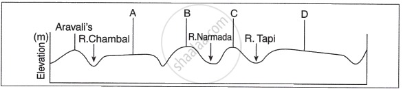
Identify any two of the relief features marked, A, B, C, and D.
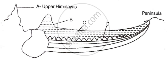
Study the cross section given below which represents the basin of the lndo-Gangetic plain.
- Name the features B, C and D in the cross section.
- Which layer of sediments among the above features is new and fertile.
Differentiate between barind and bhur with reference to the Indus-Ganga-Brahmaputra plain.
Mention two differences between the Peninsular Plateau and the Himalayas.
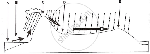
Identify any four of the features marked A-E in the diagram given below:
Mention any two differences between the Western Ghats and the Eastern Ghats.
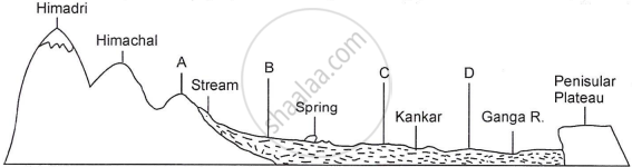
The figure below represents a topographic section from the Himalayas to the Peninsular region. Identify any two of the features marked A, B, C and D.
Mention any two differences between the Bhabar and the Tarai regions.
LONG-ANSWER TYPE QUESTIONS
Describe the relief features of the mountains in north India.
With reference to the Deccan Plateau in India, answer the following question:
What type of rocks is it made of?
With reference to the Deccan Plateau in India, answer the following question:
Give any two characteristic features of this relief division.
Mention any two differences between the Western Ghats and the Eastern Ghats.
With reference to the Western Ghats, answer the following question:
What is another name for them?
With reference to the Western Ghats, answer the following question:
Give two characteristic features of this relief division.
Mention two differences between the Andaman & Nicobar Islands and the Lakshadweep Islands.
Give any three differences between Eastern Coastal lowland and Western Coastal lowland.
Name the two rivers that make the easternmost and the westernmost limits of Kumaon Himalayas.
State the location and extent of Bhabar.
Mention any two differences between the Bhabar and the Tarai regions.
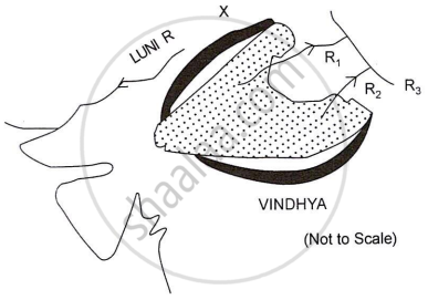
The diagram below represents the north-western part of the Peninsular Plateau:
- Identify the dotted region. Name the predominant rock that constitutes the region.
- Label the mountain range shown as X and the rivers R1, R2 and R3.
Name any two physical divisions of India.
State two characteristic features of physical divisions of India.
Give three differences between the Western and the Eastern Himalayas.
MAP WORK
Show the following relief feature on the outline map of India and write its name:
Mark the Shiwalik range and the Shipki La pass.
Show the following relief feature on the outline map of India and write its name:
Mountain range in the north of the Tapi river and runing parallel to it.
[Hint: The Satpura Range]
Show the following relief feature on the outline map of India and write its name:
The oldest mountain range of India.
Show the following relief feature on the outline map of India and write its name:
Mark and name the highest peak in the Western Ghats.
[Hint: Anai Mudi, 2695 metres]
Show the following relief feature on the outline map of India and write its name:
Mark and label the 2 passes along the North-west borders of India.
Solutions for 3: Relief
D. R. Khullar solutions for Geography [English] Class 12 ISC chapter 3 - Relief
Shaalaa.com has the CISCE Mathematics Geography [English] Class 12 ISC CISCE solutions in a manner that help students grasp basic concepts better and faster. The detailed, step-by-step solutions will help you understand the concepts better and clarify any confusion. D. R. Khullar solutions for Mathematics Geography [English] Class 12 ISC CISCE 3 (Relief) include all questions with answers and detailed explanations. This will clear students' doubts about questions and improve their application skills while preparing for board exams.
Further, we at Shaalaa.com provide such solutions so students can prepare for written exams. D. R. Khullar textbook solutions can be a core help for self-study and provide excellent self-help guidance for students.
Concepts covered in Geography [English] Class 12 ISC chapter 3 Relief are Overview of Relief, Physical Division of India > The Peninsula, Western Himalayas VS Eastern Himalayas, Western Ghats VS Eastern Ghats, Physical Division of India > The Coastal Plains, The Himalayan Mountain Complex, Regional Divisions of the Himalayas, Significance of the Himalayas, The Indus-Ganga-Brahmaputra Plain, Comparison of Plains in Northern India, Regional Divisions of the Plain, Significance of the Plain, Physical Division of India > The Peninsula, Physical Division of India > The Island Group.
Using D. R. Khullar Geography [English] Class 12 ISC solutions Relief exercise by students is an easy way to prepare for the exams, as they involve solutions arranged chapter-wise and also page-wise. The questions involved in D. R. Khullar Solutions are essential questions that can be asked in the final exam. Maximum CISCE Geography [English] Class 12 ISC students prefer D. R. Khullar Textbook Solutions to score more in exams.
Get the free view of Chapter 3, Relief Geography [English] Class 12 ISC additional questions for Mathematics Geography [English] Class 12 ISC CISCE, and you can use Shaalaa.com to keep it handy for your exam preparation.
