Advertisements
Advertisements
Questions
Explain How is distribution of annual rainfall in related to the relief of the country? with examples.
How is distribution of annual rainfall in related to the relief of the country?
Advertisements
Solution
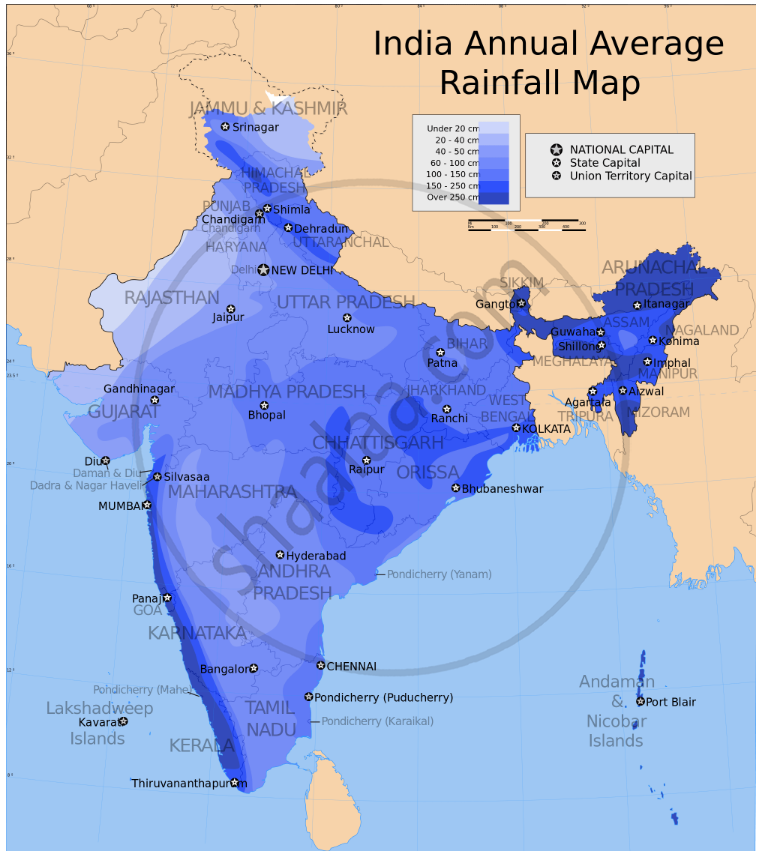
The Western Ghats: places to the windward side of the Ghats, e.g., Mumbai, Goa, Mangalore, Kerala coasts, get heavy rain. Places on the leeward side like Pune, the Deccan plateau, Chennai, get less rain.
Garo-Khasi Hills: Cherrapunji, which is favourably situated in these hills, gets entrapped in the Bay of Bengal branch of the S.W. Monsoon and gets very heavy rain; Shillong, which lies on the leeward side of these Hills gets less rain.
Aravalli Hills: These hills run parallel to the Arabian Sea branch of the S.W. Monsoon and are not conducive to rain. Besides, the Bay of Bengal winds of the S.W. Monsoon coming from the east is blocked and hence Rajasthan, lying on the leeward side of these Hills, gets little rain. This is why Thar is a desert.
The Himalaya Mountains block the Bay of Bengal branch of the S.W. Monsoon from crossing the mountains. The places on the southern slopes of the Mountains get heavy rain.
RELATED QUESTIONS
There is plenty of rain in India during the rainy season, yet we need irrigation. Give two reasons to support this statement.
Give a reason for each of the following:
Kolkata receives heavier rain than Lucknow.
Mention the geographical reason for the following:
Mangalore is not cold even in the month of December.
Give reasons for the following:
When the Malabar Coast is receiving heavy rainfall in July, the Tamil Nadu coast is comparatively dry.
Study the data of distribution of temperature and rain for Station X and answer the questions that follow :
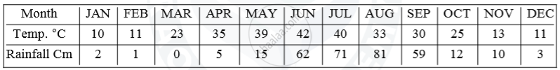
(i) Is Station X in the coastal area or in the interior of the country?
(ii) Calculate the total annual rainfall for Station X.
(iii) Name the wind that brings most of the rainfall to Station X.
Re-arrange the ten stations in two different sequences:
(i) According to their distance from the equator.
(ii) According to their altitude above mean sea-level.
Name two types of cyclonic systems that affect India and two areas that receive rainfall from these systems.
Name the areas receiving very heavy rainfall on account of favourable situation of a mountain
Seventy-five percentage of Indian rainfall is from this wind.
What is the source of winter rainfall in Punjab?
