Advertisements
Advertisements
प्रश्न
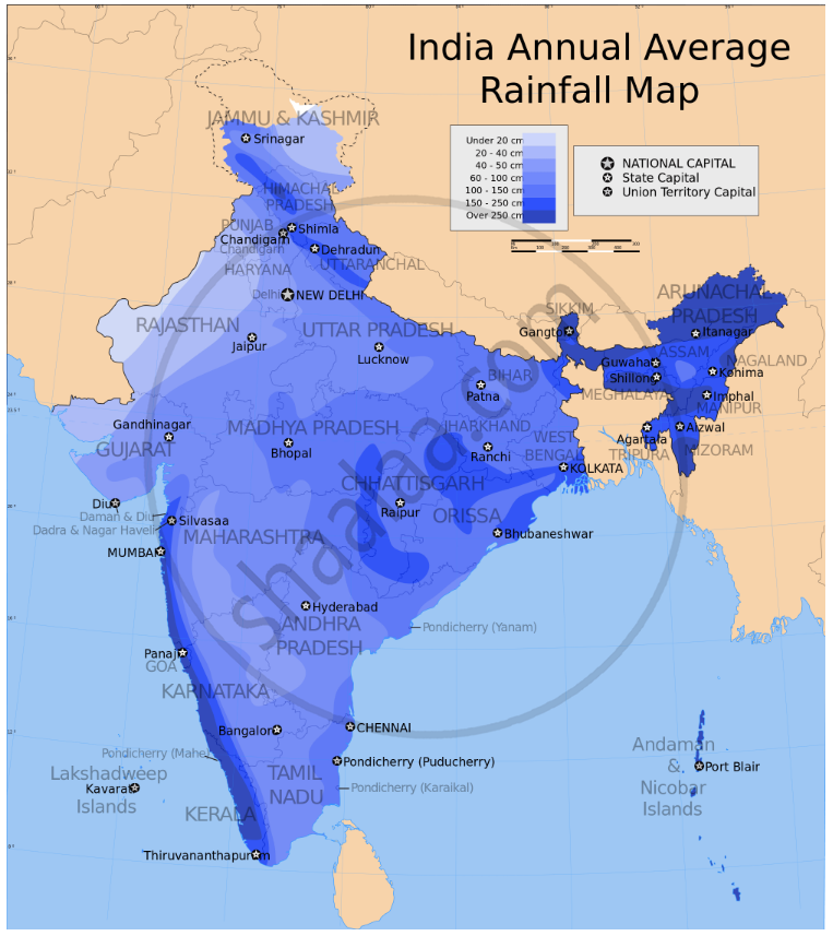
Explain How is distribution of annual rainfall in related to the relief of the country? with examples.
How is distribution of annual rainfall in related to the relief of the country?
Advertisements
उत्तर
The Western Ghats: places to the windward side of the Ghats, e.g., Mumbai, Goa, Mangalore, Kerala coasts, get heavy rain. Places on the leeward side like Pune, the Deccan plateau, Chennai, get less rain.
Garo-Khasi Hills: Cherrapunji, which is favourably situated in these hills, gets entrapped in the Bay of Bengal branch of the S.W. Monsoon and gets very heavy rain; Shillong, which lies on the leeward side of these Hills gets less rain.
Aravalli Hills: These hills run parallel to the Arabian Sea branch of the S.W. Monsoon and are not conducive to rain. Besides, the Bay of Bengal winds of the S.W. Monsoon coming from the east is blocked and hence Rajasthan, lying on the leeward side of these Hills, gets little rain. This is why Thar is a desert.
The Himalaya Mountains block the Bay of Bengal branch of the S.W. Monsoon from crossing the mountains. The places on the southern slopes of the Mountains get heavy rain.
APPEARS IN
संबंधित प्रश्न
Give reasons for the following:
When the Malabar Coast is receiving heavy rainfall in July, the Tamil Nadu coast is comparatively dry.
- Name two rainiest stations.
- Name two driest stations.
- Two stations with the most equable climate.
- Two stations with the most extreme climate.
- Two stations are most influenced by the Arabian branch of southwest monsoons.
- Two stations are most influenced by the Bay of Bengal branch of south-west monsoons.
- Two stations influenced by both branches of the south-west monsoons
- Two stations influenced by retreating and north-east monsoons.
- Two stations are receiving winter showers from the western disturbances.
- The two hottest stations in the months of
- February
- April
- May
- June
Which type of climate is experienced in the Northern Plains of India? State one main characteristic of this type of climate.
India is known as the land of the endless growing Season. Explain.
Why does Kanyakumari experience an equable climate?
Mention why does Mumbai receive more rainfall than Pune.
Rajasthan receives very little rainfall.
Study the table given below and answer the questions that follow:
| Station | Month | J | F | M | A | M | J | J | A | S | O | N | D |
| A | Temperature in Degree C. | 14.4 | 16.7 | 23.3 | 30.0 | 33.3 | 33.3 | 30.0 | 29.4 | 28.9 | 25.6 | 19.4 | 15.6 |
| Rainfall in cm | 2.5 | 1.5 | 1.3 | 10 | 1.8 | 7.4 | 19.3 | 17.8 | 11.9 | 1.3 | 0.2 | 1.0 | |
| B | Temperature in Degree C. | 24.4 | 24.4 | 26.7 | 28.3 | 300 | 28.9 | 27.2 | 27.2 | 27.2 | 27.8 | 27.2 | 25.0 |
| Rainfall in cm | 0.2 | 0.2 | 0.3 | 10 | 1.8 | 50.6 | 61.0 | 24.8 | 24.8 | 24.8 | 1.0 | 0.7 |
(i) Calculate the annual rainfall in station A.
(ii) What is the annual range of temperature in station B?
(iii) Which of the two stations has an equable climate?
Name the winds which provide relief rainfall to the Tamil Nadu coast?
Write a note on the uneven distribution of rainfall in India.
