Advertisements
Chapters
1: Interpretation of Topographical Maps
2: Contours
3: Scales and Direction
4: Map Reading and Interpretation
5: Map of India
PART II - GEOGRAPHY OF INDIA
6: Location, Extent and Physical Features
7: Climate
8: Soil Resources
9: Natural Vegetation
10: Water Resources
11: Mineral Resources
12: Conventional Sources of Energy
13: Non-Conventional Sources of Energy
14: Agriculture - I
15: Agriculture - II: Food Crops
16: Agriculture - III: Cash Crops (1)
17: Agriculture - IV: Cash Crops (2)
18: Manufacturing Industries (Agro-Based)
19: Mineral Based Industry
▶ 20: Transport
Chapter 21: Waste Management - I: Impact of Waste Accumulation
Chapter 22: Waste Management - II: Safe Disposal of Waste
![Morning Star solutions for Total Geography [English] Class 10 ICSE chapter 20 - Transport - Shaalaa.com](/images/total-geography-english-class-10-icse_6:9033996325ef4d37a61a084b4444e2b2.jpg "Morning Star solutions for Total Geography [English] Class 10 ICSE chapter 20 - Transport")
Advertisements
Solutions for Chapter 20: Transport
Below listed, you can find solutions for Chapter 20 of CISCE Morning Star for Total Geography [English] Class 10 ICSE.
Morning Star solutions for Total Geography [English] Class 10 ICSE 20 Transport EXERCISES [Pages 250 - 253]
Choose the correct option:
Which of the following is an important difference between a highway and an expressway?
Presence of multiple roads on an expressway.
Controlled access through absence of multiple roads on an expressway.
Presence of large number of intersections on an expressway.
All of the above.
You work at Moolchand Weavers at Varanasi. You have a large consignment of silk fabric that you need to export to Japan via the Haldia port. Which would be your preferred mode of transportation?
Roadways
Railways
Waterways
Airways
Assertion (A): Transport system is like the arteries and veins in the human body.
Reason (R): Transportation helps in the better utilisation of the resources.
Both A and R are true and R is the correct explanation of A.
Both A and R are true but R does not explain A.
A is true but R is false.
A is false but R is true.
The North South corridor connects ______.
Porbandar to Silchar
Mumbai to Odisha
Srinagar to Kanyakumari
Lucknow to Ghazipur
The two terminal points of East-West corridor are ______.
Mumbai and Nagpur
Nagpur and Siligudi
Mumbai and Kolkata
Porbandar and Silchar
Mumbai and Dispur
Ahmedabad and Imphal
Surat and Gangtok
The North-South and East West Corridors meet at ______.
Delhi
Jhansi
Prayagraj
Jaipur
Assertion (A): The traffic on National Highways has been growing due to industrialisation in the country.
Reason (R): NHAI is responsible for the development, maintenance and management of National Highways.
Both A and R are true and R is the correct explanation of A.
Both A and R are true but R does not explain A.
A is true but R is false.
A is false but R is true.
Which mode of transport allows farmers to move their perishable products quickly to the markets?
Railways
Airways
Roadways
Waterways
Assertion (A): The traffic on Indian roads, especially in cities, is too high.
Reason (R): Traffic on roads increases travel time and causes congestion, pollution and road accidents.
Both A and R are true and R is the correct explanation of A.
Both A and R are true but R does not explain A.
A is true but R is false.
A is false but R is true.
The railway track system is based on which of the following?
Width of the track
Length of the track
Route of the track
Load of the track
Which of the tracks is called the India gauge?
Narrow Gauge
Metre Gauge
Broad Gauge
All of the above
Assertion (A): Railway system has been divided into 18 zones.
Reason (R): Indian Railway’s huge size will put pressure on a centralised management system.
Both A and R are true and R is the correct explanation of A.
Both A and R are true but R does not explain A.
A is true but R is false.
A is false but R is true.
The distance between rails in a metre gauge is ______.
l.67 m
1 m
0.762 m
2 m
Which of the following is an advantage of airways?
Ease of crossing difficult terrain
Dependency on weather conditions
Carriage of low tonnage
Fuel used is petroleum
Of the total navigable length of 20,236 km, 17,980 km of the river and 2,256 km of canals can be used by mechanised flat bottom vessels. Which transport is referred to here?
Inland waterways
Oceanic waterways
Motorways
All of them
What is common in Haldia and Nhava Sheva ports?
Both are natural harbours.
Both were constructed with the aim to reduce pressure on major ports.
Both cater to cruise liners.
All of the above.
The rivers of Peninsular India are not ideal for use as inland waterways due to the presence of ______.
estuaries
waterfalls
stones and silt on the river beds
tributaries
Assertion (A): Inland Waterways Authority of India (IWAI) is the statutory authority in charge of the waterways in India.
Reason (R): Freight transportation by waterways is highly utilised in India.
Both A and R are true and R is the correct explanation of A.
Both A and R are true but R does not explain A.
A is true but R is false.
A is false but R is true.
Inland waterways are ______ and ______.
Expensive; inaccessible
Cheap; environment friendly
Cheap; carry low tonnage
Cheap; easily cross barriers
Which of the following ports is not a natural harbour?
Mumbai
Kochi
Ennore
Visakhapatnam
Answer the following questions:
Name the types of roads used in India. Which agency is responsible for maintenance of each category separately?
Name the two major projects developed by NHAI.
Transport is the backbone of a country’s economy. Give reasons to support your answer.
Why is road transport in India considered more useful than rail transport? State two reasons in support of your answer.
What is an expressway?
Name one expressway.
Give two points of difference between highways and expressways.
Write any four advantages of railways.
Mention one disadvantage of rail transport.
Mention any three problems being faced by the Indian Railways.
What are National Highways?
What is the Golden Quadrilateral Project?
State one economic benefit of the Golden Quadrilateral Project.
Give three points to explain the role of roads in the economic development of the country.
What is the significance of an efficient transport system?
Name the types of gauges of railways used in India.
Give a geographical reason for the following:
Railways bind the economic and cultural life of the country.
Give a geographical reason for the following:
Railways are not common in North-East India.
Give a geographical reason for the following:
North India is better suited for railways and roadways.
How is the Indian rail network one of the largest and busiest networks in the world?
Name the regulatory body looking after air transport in India. State any two of its functions.
Discuss the contribution of Air India in the air transport of India.
List two advantages of air transport in India.
List one disadvantage of air transport in India.
Give two advantages of helicopter services over aeroplane services.
Give one disadvantage of helicopter services over aeroplane services.
Explain why India has an extensive network of waterways.
Explain the role of oceanic waterways in the transport sector of India’s economy.
Give a geographical reason for the following:
The Ganga is navigable from its mouth right upto Allahabad.
Give a geographical reason for the following:
The Peninsular rivers are not ideal for inland water transport.
Give a geographical reason for the following:
Mumbai is a harbour and a port.
| All rivers and canals of northern India serve as inland waterway for transport of people and goods. The growth of this means of transport is however reduced or limited with time due to development of other means of transport. The Ganga and Brahmaputra in north India and all peninsular rivers in the deltaic region serve as inland waterways. |
- On what factors does the growth of this means of transport depend on?
- Mention the disadvantages of this means of transport?
What are the two prerequisites of waterways to be navigable?
Give two points of difference between Inland Waterways and Oceanic Waterways.
Give a geographical reason for the following:
Inland waterways are more economical than other modes of transport.
Give reasons for the following:
A good transport network promotes industrial development.
Give a geographical reason for the following:
Airways are quite useful during natural calamity.
Give two points of difference between a port and a harbour.
On which river and between which two places does the National Waterway No. 2 lie?
The Government of India is constructing airports in towns, tourist destinations, pilgrimage points, etc. As a student of geography give reasons for this.
With the help of an example explain how development of waterways give impetus to industry.
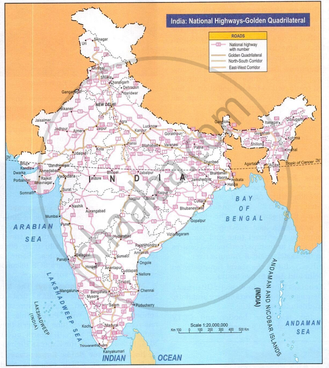
Refer to the map given below and answer the following questions:
- Name four cities that are connected by the north-south corridor.
- Give any two reasons in support of the NHAI’s highway projects.
How does the Yamuna Expressway help in giving impetus to the sugar industry?
Thinking Skills
In India, latest technologies and improved management techniques are being used to establish a highly developed network of roads. This has led to a rapid increase in the number of vehicles on the road, which in turn lead to a sharp increase in pollution levels, especially in cities. Do you think we should halt the process of making new roads, bridges and tunnels to check the increase in vehicular pollution? Give reasons to support your answer.
Instead of developing road transport, India should focus more on the development of Metro rail. Do you agree with this statement? Give reasons to support your view.
Solutions for 20: Transport
Morning Star solutions for Total Geography [English] Class 10 ICSE chapter 20 - Transport
Shaalaa.com has the CISCE Mathematics Total Geography [English] Class 10 ICSE CISCE solutions in a manner that help students grasp basic concepts better and faster. The detailed, step-by-step solutions will help you understand the concepts better and clarify any confusion. Morning Star solutions for Mathematics Total Geography [English] Class 10 ICSE CISCE 20 (Transport) include all questions with answers and detailed explanations. This will clear students' doubts about questions and improve their application skills while preparing for board exams.
Further, we at Shaalaa.com provide such solutions so students can prepare for written exams. Morning Star textbook solutions can be a core help for self-study and provide excellent self-help guidance for students.
Concepts covered in Total Geography [English] Class 10 ICSE chapter 20 Transport are Introduction and Importance of Transport System in India, Types of Transport > Roadways, Advantages and Disadvantages of Roadways, Types of Transport > Railways, Advantages and Disadvantages of Railways, Types of Transport > Airways, Advantages and Disadvantages of Airways, Types of Transport > Waterways, Oceanic Waterways or Coastal Shipping, Expressways VS National Highways, Difference Between a Port and a Harbour, Overview of Transport in India, Introduction and Importance of Transport System in India, Types of Transport > Roadways, Advantages and Disadvantages of Roadways, Types of Transport > Railways, Advantages and Disadvantages of Railways, Types of Transport > Airways, Advantages and Disadvantages of Airways, Types of Transport > Waterways, Oceanic Waterways or Coastal Shipping, Expressways VS National Highways, Difference Between a Port and a Harbour, Overview of Transport in India.
Using Morning Star Total Geography [English] Class 10 ICSE solutions Transport exercise by students is an easy way to prepare for the exams, as they involve solutions arranged chapter-wise and also page-wise. The questions involved in Morning Star Solutions are essential questions that can be asked in the final exam. Maximum CISCE Total Geography [English] Class 10 ICSE students prefer Morning Star Textbook Solutions to score more in exams.
Get the free view of Chapter 20, Transport Total Geography [English] Class 10 ICSE additional questions for Mathematics Total Geography [English] Class 10 ICSE CISCE, and you can use Shaalaa.com to keep it handy for your exam preparation.
