Advertisements
Chapters
1: Locational Setting of India
2: Geological Evolution and Structure
3: Relief
▶ 4: Drainage
5: Climate
6: Natural Vegetation
UNIT 2 : POPULATION AND HUMAN SETTLEMENTS
7: Population
8: Migration Trends
9: Demographic Attributes
10: Rural Settlements
11: Urban Settlements
UNIT 3 : RESOURCES OF INDIA AND THEIR UTILISATION
12: Environmental Management and Land use Pattern
13: Water Resources and Types of Irrigation
14: Agriculture
15: Fisheries
16: Mineral and Power Resources
UNIT 4 : INFRASTRUCTURAL RESOURCES
17: Transport and Communication
18: Industries
19: Tourism Industry
UNIT 5 : REGIONAL ECONOMIC DEVELOPMENT
20: Regional Economic Development: Case Studies
PART 2 - Practical Work and Project Report
1: Scales
2: Representation of Relief
3: Study and Interpretation of Topographical Maps
4: Geographical Information System (GIS)
5: Remote Sensing
6: Surveying
7: Project Work
![D. R. Khullar solutions for Geography [English] Class 12 ISC chapter 4 - Drainage - Shaalaa.com](/images/geography-english-class-12-isc_6:9fc85d81f6f64f1b9b714d2c00427833.jpg "D. R. Khullar solutions for Geography [English] Class 12 ISC chapter 4 - Drainage")
Advertisements
Solutions for Chapter 4: Drainage
Below listed, you can find solutions for Chapter 4 of CISCE D. R. Khullar for Geography [English] Class 12 ISC.
D. R. Khullar solutions for Geography [English] Class 12 ISC 4 Drainage EXERCISES [Pages 52 - 54]
SHORT-ANSWER TYPE QUESTIONS
Write a short note on the Indus river.
Write a short note on the Ganga river.
Write a short note on the Brahmaputra river.
Write a short note on the Narmada river.
Write a short note the Cauvery River.
Why do the rivers on the western coast have no deltas, even though they transport a lot of sediment with them?
What is a gorge?
Give two examples of gorge in north India.
What is a delta?
Give four examples of delta in India.
Write the names of rivers in the figure denoted by the following numbers:
3, 7, 12, 20, 26, 27, 2, 10, 18, 19, 22, and 31. Also write their numbers alongside.

Define the term antecedent drainage.
Name three antecedent rivers of India.
Explain three salient features of Himalayan rivers flowing in India.
Describe the catchment area, terrain flow pattern of the Ganga river system.
Give the salient features of the rivers of the Peninsular India.
Explain why there is a large number of deltas on the eastern coast of India while its western coast is without even single major delta.
LONG-ANSWER TYPE QUESTIONS
Explain briefly the theory of the ‘Indobrahm’ river as believed by some geologists. Also mention the two principal grounds on which the theory has been discarded.
Bring out clearly the differences in the drainage features and hydrological characteristics between the Himalayan rivers and the Peninsular rivers. Support your answer with suitable examples.
Bring out clearly the differences in the drainage features and hydrological characteristics between the Himalayan rivers and the Peninsular rivers. Support your answer with suitable examples.
D. R. Khullar solutions for Geography [English] Class 12 ISC 4 Drainage MAP WORK [Pages 54 - 55]
MAP WORK
On the outline map of India locate and label the following:
A river flowing through three different countries, including India and having different names.
On the outline map of India locate and label the following:
A river flowing through three different countries, including India and having different names.
On the outline map of India locate and label the following:
A river which originates in the Himalayas and flows through four Indian states before forming the largest delta of the world.
On the outline map of India locate and label the following:
A river which originates in the Himalayas and flows through four Indian states before forming the largest delta of the world.
On the outline map of India locate and label the following:
A river which was probably a tributary of the Indus in the Pliestocene age but is now a tributary of the Ganga.
[Hint: The Yamuna]
On the outline map of India locate and label the following:
A major river, originating from Mansarovar region, flowing towards the west and forming a delta.
[Hint: The Indus]
On the outline map of India locate and label the following:
The longest river of the Peninsular India.
On the outline map of India locate and label the following:
The longest river of the Peninsular India.
On the outline map of India locate and label the following:
A river on which Hirakud Dam is located.
[Hint: The Mahanadi]
On the outline map of India locate and label the following:
A river which often shifts its course, causes floods and has been notorious as the ‘sorrow of Bihar’.
[Hint: Kosi]
On the outline map of India locate and label the following:
A river flowing through a rift valley.
On the outline map of India locate and label the following:
An important river of the Great Indian Desert.
[Hint: Luni]
On the outline map of India locate and label the following:
A river on which the highest gravity dam in the world has been constructed.
[Hint: The Satluj where Bhakra Dam has been constructed]
On the outline map of India locate and label the following:
A major river originating from a spring near Mahabaleshwar.
[Hint: The Krishna]
On the outline map of India locate and label the following:
A river of south India which receives rain water both in summer and winter.
[Hint: The Cauvery]
On the outline map of India locate and label the following:
A tributary of the Yamuna which is notorious for its ravines.
[Hint: The Chambal]
D. R. Khullar solutions for Geography [English] Class 12 ISC 4 Drainage Examination corner [Pages 55 - 56]
SHORT-ANSWER TYPE QUESTIONS
Name and trace the course of the river on which the Bhakra Nangal Project is located.
Why is Godavari river often referred to as ‘Dakshin Ganga’ or ‘Vridha Ganga’?
Which river is known as the ‘Dakshin Ganga’? Why?
Name any two tributaries of the Godavari river.
Why are rivers flowing into the Bay of Bengal able to build wide and extensive deltas?
State two differences between Himalayan and Peninsular river systems.
Differentiate between the east-flowing and the west-flowing rivers of the Deccan plateau of India.
What are ‘badlands’?
Name one river draining the badlands of India.
Explain the term braided river.
Give an example of a braided river.
Name the two streams which unite at Devaprayag to form into river Ganga.
The rivers of North India are Antecedent in nature. Explain with an example.
With reference to the Godavari River, name the following:
The State where it originates.
With reference to the Godavari River, name the following:
The State where it forms its delta.
LONG-ANSWER TYPE QUESTIONS
State two differences between Himalayan and Peninsular river systems.
Name any two Himalayan drainage systems of India.
The diagram given below shows the regimes (annual fluctuation in discharge) of two hypothetical rivers X and Y.
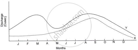
- Identify which of the two rivers represants the regime of a peninsular river. Give a reason for your answer.
- Name the peninsular river which is an exception to the general pattern. Why is it an exception?
Explain the following:
The Himalayan rivers are typical examples of antecedent drainage.
MAP WORK
On the outline map of India locate and label the following:
A river on which the highest gravity dam in the world has been constructed.
[Hint: The Satluj where Bhakra Dam has been constructed]
On the outline map of India locate and label the following:
A river flowing through three different countries, including India and having different names.
On the outline map of India locate and label the following:
A river of south India which receives rain water both in summer and winter.
[Hint: The Cauvery]
On the outline map of India locate and label the following:
A river flowing through a rift valley.
On the outline map of India locate and label the following:
The longest river of the Peninsular India.
On the outline map of India locate and label the following:
The river on which the Damodar Valley Corporation is located.
[Hint: The Damodar]
Solutions for 4: Drainage
D. R. Khullar solutions for Geography [English] Class 12 ISC chapter 4 - Drainage
Shaalaa.com has the CISCE Mathematics Geography [English] Class 12 ISC CISCE solutions in a manner that help students grasp basic concepts better and faster. The detailed, step-by-step solutions will help you understand the concepts better and clarify any confusion. D. R. Khullar solutions for Mathematics Geography [English] Class 12 ISC CISCE 4 (Drainage) include all questions with answers and detailed explanations. This will clear students' doubts about questions and improve their application skills while preparing for board exams.
Further, we at Shaalaa.com provide such solutions so students can prepare for written exams. D. R. Khullar textbook solutions can be a core help for self-study and provide excellent self-help guidance for students.
Concepts covered in Geography [English] Class 12 ISC chapter 4 Drainage are Overview of Drainage, Evolution of the Indian River System, The Himalayan River System, The Peninsular Rivers, Differences between the Himalayan and the Peninsular River Systems.
Using D. R. Khullar Geography [English] Class 12 ISC solutions Drainage exercise by students is an easy way to prepare for the exams, as they involve solutions arranged chapter-wise and also page-wise. The questions involved in D. R. Khullar Solutions are essential questions that can be asked in the final exam. Maximum CISCE Geography [English] Class 12 ISC students prefer D. R. Khullar Textbook Solutions to score more in exams.
Get the free view of Chapter 4, Drainage Geography [English] Class 12 ISC additional questions for Mathematics Geography [English] Class 12 ISC CISCE, and you can use Shaalaa.com to keep it handy for your exam preparation.
