Advertisements
Online Mock Tests
Chapters
![Balbharati solutions for Geography [English] Standard 12 Maharashtra State Board chapter 3 - Human Settlements and Land Use - Shaalaa.com](/images/geography-english-standard-12-maharashtra-state-board_6:66e7992f303e487081d13952aa9844c6.jpg "Balbharati solutions for Geography [English] Standard 12 Maharashtra State Board chapter 3 - Human Settlements and Land Use")
Advertisements
Solutions for Chapter 3: Human Settlements and Land Use
Below listed, you can find solutions for Chapter 3 of Maharashtra State Board Balbharati for Geography [English] Standard 12 Maharashtra State Board.
Balbharati solutions for Geography [English] Standard 12 Maharashtra State Board 3 Human Settlements and Land Use Intext Questions [Pages 21 - 28]
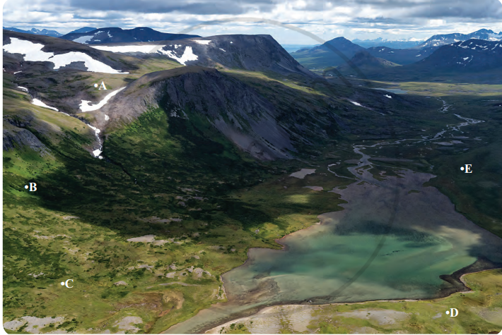
Observe Fig. 3.1 and answer the following questions:
- Where are human settlements likely to develop : A, B, C, D or E? Why?
- In the above figure in which place human settlement is not likely to develop and why?
- Looking at figure above, what factors do you think could contribute to the development of human settlements?
- Can economic factors be important along with physical factors for the development of human settlements?
- Do physical factors affect the economic activities of human settlements?
- Make a list of factors which affect development of settlements in an area.
Try this.
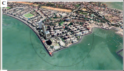
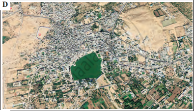
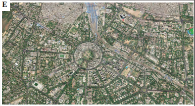
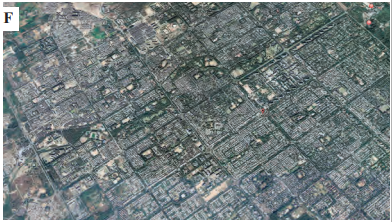
Observe different images in Fig. A to F. They show various patterns of settlements. Try to understand the difference between them. Carefully read their characteristics in second column. According to the applicable characteristics, write the alphabet of the image settlement in the place provided below the characteristics.
| Satellite images of the settlements | Characteristics of settlements |
|---|---|
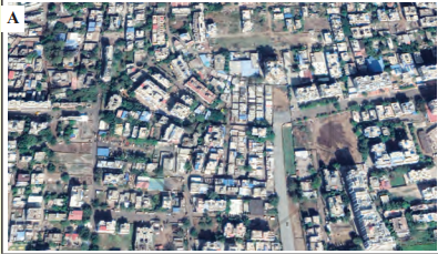 |
Linear pattern : a) Settlements occur along a road, railway, canal or river. b) They are in a straight line or take the shape of the road or the river. ☐ |
| Rectangular pattern : a) Settlements are in a straight line. b) Such lines are parallel to each other. c) These days planned cities may take such a shape. ☐ |
|
 |
Patternless: a) With the development of the settlement, the size of the population also increases. b) Increasing population leads to haphazard development of settlements. c) Houses are built as per convenience and space available. ☐ |
 |
Radial pattern: a) Settlements grow around a central object or center. b) This central point plays an important role in development of the settlements around it. ☐ |
 |
Circular pattern: a) Settlements take shape around a lake. b) Houses are closely spaced because of availability of water. ☐ |
 |
Triangular pattern: a) Found at the confluence of two rivers or roads or along sea coast. b) The settlements can grow in all three sides due to physical or social reasons. ☐ |
Let’s recall.
Distinguish between Urban settlement and rural settlement.
Visit http://censusindia.gov.in/2011- prov-results/paper2/data_files/India2/1.%20 Data%20Highlight.pdf to know how cities are divided into various types in India on the basis of their populations. Also look for examples from Maharashtra. Refer to the website and complete the table as given below:
| Classification | Population | Classification | Population |
| Class I | Class II | ||
| Class III | Class IV | ||
| Class V | Class VI | ||
| Town | City | ||
| Metropolitan cities | Mega Cities | ||
| Urban Agglomeration | Outgrowth |
Complete the table with examples from Maharashtra and India.
| Functions | Name of the cities from Maharashtra | Name of the cities from outside Maharashtra |
|---|---|---|
| Administrative | ||
| Industrial | ||
| Transport | ||
| Commercial | ||
| Mining | ||
| Cantonment | ||
| Educational | ||
| Religious | ||
| Tourism |
Think about it.
Can a town have only one function?
Why do cities become multi-functional?
Try this.
Do the following activity in class with your teacher.
1) Obtain a map of your city or village. You can also use Google Earth and select an image of your area. Alternatively, you can also make a map of your college and surrounding area.
2) The map should include your school and nearby streets.
3) On a Xerox machine, enlarge the area on the map that surrounds your school/college.
4) Take a short walk around the area that is represented on the map with your teacher. Mark the areas according to the key with a specific colour given below.
| Land use in my city/village | Suggested colour scheme |
| Parks/open spaces | Green |
| Houses/apartments | Dark Red |
| Shops/stores/commercial establishments/malls | Light blue |
| Public buildings/offices/schools/colleges/bus station/railway station | Light Red |
| Agricultural | Yellow |
| Water bodies/rivers/ | Dark blue |
| Transportation (roads/railways, highways, etc.) | Black |
5) You may add more descriptions if required by using more colours.
6) This will help you to get an idea of what type of buildings and land use exists around the neighbourhood.
7) After coming back to the class, discuss which land use occupies more land than the others.
Find out !
Compare the cover page of Std. XII textbook with Std. XI Geography textbook. Discuss in class and write a short paragraph about the changes in land use/land cover in your own words.
Can you tell?
You know what is urban and what is rural. What will you call the area that lies between them? Discuss this in the class.
Try this.
Can you identify the problems faced by your city/town/village in terms of any one of the following?
| Sr. No. | Types of problems | Problems/issues |
| 1 | Economic | |
| 2 | Social | |
| 3 | Cultural | |
| 4 | Environmental | |
| 5 | Infrastructural | |
| 6 | Governance and Administrative | |
| 7 | Others |
Can you think of the solutions to these problems?
Make friends with maps!
See maps of Ichalkaranji city given below and observe how changes have occurred in the city over the years. Answer the questions that follow:
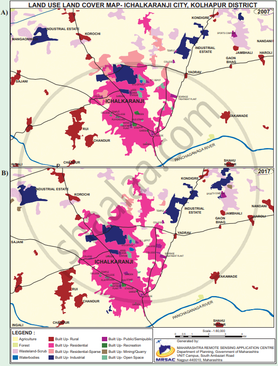
- Enlist the colours used for showing land uses in the index.
- What do the blue and the black lines show?
- What is the name of the river in the map?
- Name any two villages shown on the map.
- Which city is shown on the map?
- Which periods do the maps belong to?
- Which land covers have reduced? What are their colours?
- Which land covers seen to have increased? What are their colours?
- Which land covers have been replaced by the increased land covers?
- Write a conclusive note comparing both the maps.
Balbharati solutions for Geography [English] Standard 12 Maharashtra State Board 3 Human Settlements and Land Use Exercise [Pages 29 - 31]
Identify the correct correlation:
Assertion: Settlements can be of various types.
Reasoning: Various physical factors affect the growth of settlements.
Only A is correct.
Only R is correct
Both A and R are correct and R is the correct explanation of A.
Both A and R are correct but R is not the correct explanation of A.
Assertion (A): When cities grow, their functions also grow.
Reasoning (R): Cities can have only one function.
Only A is correct.
Only R is correct.
Both A and R are correct and R is the correct explanation of A.
Both A and R are correct but R is not the correct explanation of A.
Give a geographical reason:
Not all rural settlements change into urban settlements.
Give a geographical reason:
In rural settlements, land use is related to agriculture.
Give a geographical reason:
Rural-urban fringes have the characteristics of both urban and rural settlements.
Give a geographical reason:
Growth of urban areas is linked to land use.
Write a short note on:
The interrelationship between rural and urban settlements.
Write a short note on:
Problems of urban settlements.
Write a short note on:
Suburbs
Write a short note on:
Mixed land use.
Explain the characteristics of rural settlements.
What factors are responsible for the development of various patterns in the settlement? Give examples.
Differentiate between:
Land use and Land cover
Differentiate between:
Barren and Non-agricultural land
Differentiate between:
Radial Pattern and Circular Pattern
Differentiate between :
Nucleated and Dispersed Settlement
Draw a diagram and label it:
Linear settlement
Draw a neat and well-labeled diagram for:
Radial settlement
Draw a neat and well-labeled diagram for:
Compact settlement
Draw a neat and well-labelled diagram for:
Dispersed settlement
Write a note in your own words about how land use in Lonar city has evolved over time.

Read the given passage and answer the following questions:
Different types of human settlements include hamlets, villages, small towns, large towns, isolated places, cities, and conurbations. In some systems, types of human settlements are broken up into urban, suburban, and rural; for example, the U.S. Census Bureau divides settlements into urban or rural categories based on precise definitions. Small settlements, such as hamlets and villages, have low populations and restricted access to services. Larger types of settlements, such as cities, have higher populations, higher densities, and greater access to services. For example, a village may have only one or two general stores, while a large metropolis may have many specialized stores and chain stores. These differences are known as low-order service settlements and high-order service settlements. Larger settlements also have a sphere of influence affecting surrounding settlements. Settlements may also be divided by the site chosen, such as sites selected based on resources, trading points, defensive sites, shelter, and relationship to water resources. The functions of human settlements also differ, as settlements may be established as ports, market towns, and resorts. Types of rural settlements may also be classified by function, such as proximity to farming, fishing, and mining. Settlements that focus on one economic activity are called single functional settlements. Human settlements may be permanent or temporary. For example, a refugee camp is a temporary settlement, while a city is a permanent settlement.
1) Which human settlements are mentioned in the passage above?
2) On what basis are urban and rural areas classified?
3) What are the functions carried out in rural settlements?
4) Explain the difference between low-order service and high-order service settlements.
Solutions for 3: Human Settlements and Land Use
Balbharati solutions for Geography [English] Standard 12 Maharashtra State Board chapter 3 - Human Settlements and Land Use
Shaalaa.com has the Maharashtra State Board Mathematics Geography [English] Standard 12 Maharashtra State Board Maharashtra State Board solutions in a manner that help students grasp basic concepts better and faster. The detailed, step-by-step solutions will help you understand the concepts better and clarify any confusion. Balbharati solutions for Mathematics Geography [English] Standard 12 Maharashtra State Board Maharashtra State Board 3 (Human Settlements and Land Use) include all questions with answers and detailed explanations. This will clear students' doubts about questions and improve their application skills while preparing for board exams.
Further, we at Shaalaa.com provide such solutions so students can prepare for written exams. Balbharati textbook solutions can be a core help for self-study and provide excellent self-help guidance for students.
Concepts covered in Geography [English] Standard 12 Maharashtra State Board chapter 3 Human Settlements and Land Use are Overview of Human Settlements and Land Use, Types of Settlement, Types of Urban Settlements, Land Use, Land Use Classification, Land Use in Rural Area, Human Settlements, Land Use in Urban Areas, Rural-urban Fringe, Suburbs.
Using Balbharati Geography [English] Standard 12 Maharashtra State Board solutions Human Settlements and Land Use exercise by students is an easy way to prepare for the exams, as they involve solutions arranged chapter-wise and also page-wise. The questions involved in Balbharati Solutions are essential questions that can be asked in the final exam. Maximum Maharashtra State Board Geography [English] Standard 12 Maharashtra State Board students prefer Balbharati Textbook Solutions to score more in exams.
Get the free view of Chapter 3, Human Settlements and Land Use Geography [English] Standard 12 Maharashtra State Board additional questions for Mathematics Geography [English] Standard 12 Maharashtra State Board Maharashtra State Board, and you can use Shaalaa.com to keep it handy for your exam preparation.
