(English Medium)
Academic Year: 2025-2026
Date & Time: 18th March 2026, 11:00 am
Duration: 2h
Advertisements
- Answers to this paper must be written on the answer sheet provided. separately.
- You will not be allowed to write during the first 15 minutes.
- This time is to be spent in reading the question paper.
- The time given at the head of this Paper is the time allowed for writing the answers.
- Part I is compulsory. All questions from Part I are to be attempted.
- A total of five questions are to be attempted from Part II.
- The intended marks for questions or parts of questions are given in brackets [ ].
To be supplied with this paper: Survey of India Map Sheet No. G43S7 and 20 cm of twine.
Note:
- In all map work, make wise use of arrows to avoid overcrowding of the map.
- The extract of Survey of India Map, Sheet No. G43S7 must not be taken out of the examination hall. It must be handed over to the Supervising Examiner on completion of the paper.
- The map given at the end of this question paper must be detached, and after marking, must be fastened to your answer booklet.
- All sub-sections of the questions attempted must be answered in the correct serial order.
- All working including rough work should be done on the same answer sheet which is used to answer the rest of the paper.
Study the extract of the Survey of India Map Sheet No. G43S7 and answer the following questions:
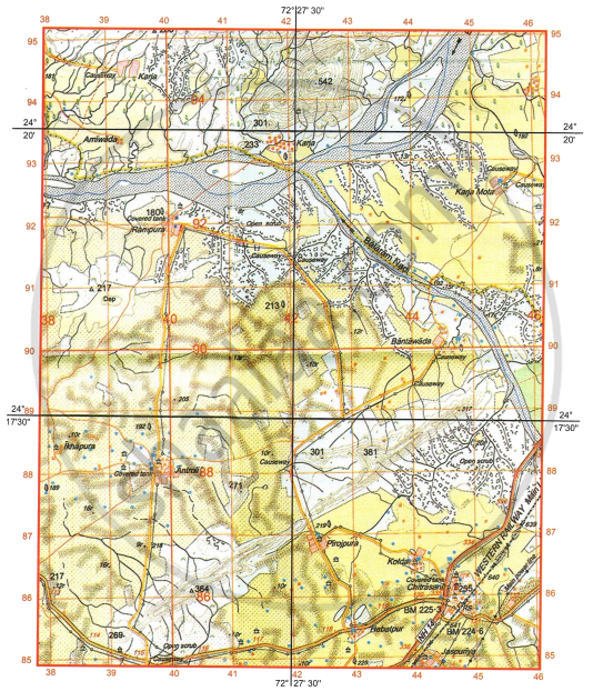
-
- What is the social significance of the temple that is found at the six-figure grid reference 362001?
- What is the reason for very few settlements in the southeastern quarter of the map extract?
-
- What is .3r in grid square 3501?
- Identify one relief feature found in the grid square 3796.
-
- The area shown on the map extract has seasonal streams, but in 3903, a large perennial water source can be seen. What may be the reason for the presence of this large perennial source of water?
- Which other source of water seen on the map extract is perennial?
-
- While travelling for work from Dhaneri (3100) to Marwada (3197) along the metalled road, Sahil crossed over a number of ‘causeways’. Why are causeways present in the area shown on the map extract?
- Identify the drainage pattern seen in the grid square 3697.
-
- What is the difference in altitude between the highest point on the map extract and the contour height in grid square 3203?
- What is the black horizontal line made between 98 and 99 northings called?
Chapter:
On the outline map of India provided:
- Mark and name an old fold mountain range of India.
-
Mark with an arrow and name the river also known as the ‘Sorrow of Bihar’.
-
Shade and label the Gulf of Kutch.
-
Mark and label the Karakoram Pass.
-
Mark and label an offshore oil field of India.
-
Shade and label the Laterite soil area in the northeastern part of India.
-
Mark and name the shared capital city of Punjab and Haryana.
-
Mark and label the Western Ghats.
-
Shade and label the river Krishna.
-
Shade and label an area of dense population.
Chapter:
Mawsynram, the rainiest place in the world, gets the rain from ______.
South-west monsoon wind - Arabian Sea branch
South-west monsoon wind - Bay of Bengal branch
Westen Disturbance
North-east monsoon wind
Chapter:
Choose the characteristic that is true about Laterite soil.
It is a clayey soil.
It is moisture retentive.
It is rich in calcium.
It undergoes desilication.
Chapter:
Identify the option which is most similar to:
Tropical Evergreen vegetation : Tall trees and hardwood
Tropical Deciduous vegetation : Pure stands
Tropical Desert vegetation : Small leaves and spines
Coniferous forests : Mountain
Littoral vegetation : Boat making
Chapter:
Assertion (A): Irrigation is practised in large parts of India.
Reason (R): India has a variety of soil types.
(A) is true and (R) is false.
(A) is false and (R) is true.
Both (A) and (R) are true and (R) is the correct explanation of (A).
Both (A) and (R) are true but (R) is not the correct explanation of (A).
Chapter:
Identify the type of coal that has the highest calorific value.
Peat
Lignite
Bituminous
Anthracite
Chapter:
The residue of ______ forms an important part of the cattle feed and manure.
groundnut
coffee
jute
pulses
Chapter:
Identify the crop that is grown in the Rabi cropping season.
Sugarcane
Rice
Mustard
Cotton
Chapter:
Which industry is ideally located close to the raw material producing area?
Silk industry
Jute industry
Cotton textile industry
Sugar industry
Chapter:
Which of the following is NOT suitable for composting?
Fruit peels
Egg shells
Neem soap
Used tea leaves
Chapter:
The picture given below depicts the use of waterway as a means of transport.
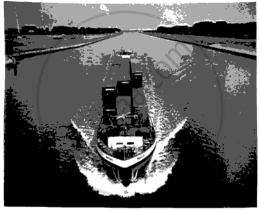
Identify the pair of cities which are most likely to be the terminal cities for the waterway shown in the above picture:
Prayagraj and Haldia
Mumbai and Goa
Chennai and Vishakhapatnam
Kochi and Mangaluru
Chapter:
Name a state in India which is the first to receive the summer monsoon and is also the last to see its retreat.
Chapter:
Mention the weather conditions experienced during the retreating monsoon season.
Chapter:
Study the map showing the area that receives rains during winter and answer the questions that follow:
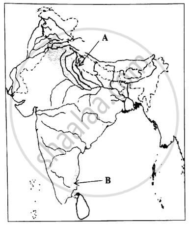
- Name the wind which brings rainfall to:
- The shaded area labelled A.
- The shaded area labelled B.
- How is the rain brought by the winds named by you in (a) above, beneficial for the area shaded A and the area shaded B?
Chapter:
Shyam attended winter trekking camps in both Nainital and in Ooty. He observed that the mountains in Nainital were ice-covered, whereas in Ooty they were ice-free.
- As a student of Geography, explain the reason for the difference in the climate of Nainital and Ooty?
- If Shyam goes to Kochi in the same season, what difference of climate will he experience?
Chapter:
Study the climate data of station X and answer the following questions:
| Month | Jan | Feb | Mar | Apr | May | June | July | Aug | Sep | Oct | Nov | Dec |
| Temperature (°C) |
13.5 | 16.8 | 22.4 | 33.6 | 38.6 | 30.2 | 29.3 | 28.4 | 27.8 | 25.7 | 19.9 | 15.5 |
| Rainfall (cm) |
1.3 | - | - | 5.9 | 12.4 | 43.9 | 51.4 | 39.8 | 20.9 | 15.1 | 2.6 | 2.1 |
- Why is there a decrease in temperature in the month of June after the high temperature of May?
- Calculate the total rainfall of the station during the rainy season and give your answer in cm.
- Is station X located near the sea or away from the sea? Give a reason for your answer.
Chapter:
Observe the picture of ex-situ soil given below and answer the questions that follow:
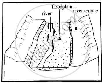
- Identify the types of soil marked as A and B.
- Which of the two, A or B, is more fertile and why?
Chapter:
- Name the soil component derived from the decay of dead plants and animals.
- Why is the component mentioned by you in (a) important for agriculture?
Chapter:
Give a geographical reason to explain the following:
In arid regions, trees are planted in rows perpendicular to wind direction.
Chapter:
Give a geographical reason for the following:
Black soil does not get leached.
Chapter:
Give a geographical reason to explain the following:
It is difficult to grow rice in red soil without the help of irrigation.
Chapter:
Name two areas in north India where soil conservation is required.
Chapter:
Name two methods of soil conservation practised in India.
Chapter:
Advertisements
Why are forests important for the Indian economy?
Chapter:
Identify the forest conservation methods described below:
A sustainable system of managing a piece of land through combined |production of agricultural crops, forest crops and animal rearing.
Chapter:
Identify the forest conservation methods described below:
Planting of trees along the side of roads, railway lines and on hill slopes.
Chapter:
Given below is an image of the forest found in marshy areas. Refer to the image and answer the questions that follow:
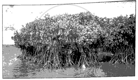
- Name the type of vegetation seen in the above image.
- Mention one adaptive feature of the trees of this vegetation.
- Name a region where this type of vegetation is commonly found in India.
Chapter:
Give one geographical reason to explain the following:
Desert vegetation has long roots.
Chapter:
Give one geographical reason to explain the following:
At higher altitudes, trees are often conical in shape.
Chapter:
Give one geographical reason to explain the following:
Tropical Monsoon Forests are also called ‘Tropical Deciduous Forests’.
Chapter:
| Raghu wants to irrigate his large field in a manner that will ensure uniform water distribution across the field, along with water conservation. |
- Name the irrigation method that will be suitable as per his need.
- How will the method of irrigation mentioned by you in (a) above help to conserve water?
Chapter:
Distinguish between Inundation Canals and Perennial Canals.
Chapter: [6] Water Resources
|
Considering the rapid depletion of groundwater and its implications for food and water security in India, sustainable management of groundwater resources is needed. Source: [Journal of Hydrology, Volume 596, May 2021] |
- How is ‘groundwater’ different from ‘surface water’?
- Why is the groundwater level rapidly declining in India?
- Name one conservation measure that will help in recharging of the groundwater.
Chapter:
Give a reason for the following:
Wells are a common means of irrigation in Northern India.
Chapter:
Give a reason for the following:
Many state governments have restricted the use of tubewells.
Chapter:
Give a reason for each of the following:
Tank irrigation is a popular method of irrigation used in Karnataka.
Chapter:
Give two advantages of using Natural gas over coal.
Chapter:
Umesh and Sagar are employed in iron ore mines in two different districts of Odisha. What are their possible places of work?
Chapter:
State two important uses of following metal.
Uses of copper
Chapter:
The Bhakra Nangal project is a joint venture of which state governments?
Chapter:
Name the river on which the Bhakra Nangal project is based.
Chapter:
Mention two benefits of the Bhakra Nangal project.
Chapter:
Give one word for the following:
The renewable energy produced by the natural rise and fall of ocean waters.
Chapter:
Name the mineral that toughens steel and makes it rust- proof.
Chapter:
Differentiate between subsistence farming and commercial farming.
Chapter:
Advertisements
- Name a state that leads in the production of jute.
- Mention a geographical factor that is responsible for the state mentioned in (a) above being the leading producer of jute.
Chapter:
Why are Silver Oak trees and Cardamom trees planted in coffee plantations along with the coffee plants?
Chapter:
Give two climatic factors that favour the cultivation of coffee.
Chapter:
Name the cropping season in which Bajra is grown.
Chapter:
Why is wheat not cultivated extensively in West Bengal and the extreme southern states of India?
Chapter:
Why is the cultivation of soyabean gaining popularity in recent times?
Chapter:
‘Not all areas of India are suitable for establishing a large-scale industry.’
Give two reasons for the above statement.
Chapter:
‘The contribution of the electronics industry is crucial for the progress and development of the Indian economy.’ State two arguments in favour of this statement.
Chapter:
Give one geographical reason to explain the following:
Work in sugar mills is a seasonal activity.
Chapter:
Give one geographical reason to explain the following:
The cotton textile industry is widely distributed in India.
Chapter:
Give one geographical reason to explain the following:
Vishakhapatnam steel plant has a unique locational advantage that enables it to procure raw materials easily and market the finished products with ease.
Chapter:
- Name the oldest iron and steel industry of India.
- Where is it located?
- Name a centre from where it gets its coal supply.
Chapter:
Inland water transport is more popular in Northern India as compared to Peninsular India. Give two reasons.
Chapter:
What is the purpose of developing the Golden Quadrilateral in India?
Chapter:
Mr. Kumar stays in Delhi with his family. Members of his family had to travel on Monday for different purposes. State the mode of transport that is most likely to be chosen by each:
- Mr. Kumar’s father wanted to travel comfortably to Patna to stay with his brother for a week.
- Mr. Kumar’s son had to attend a meeting in Ahmedabad that very evening.
- Mr. Kumar’s daughter had to meet her friend who lives in the same city, taking with her some fresh vegetables grown in their kitchen garden.
Chapter:
Give one geographical reason to explain the following:
The presence of a number of ports has strengthened the transport sector of India.
Chapter:
Give one geographical reason to explain the following:
The number of airports in the country is on the rise.
Chapter:
Give one geographical reason to explain the following:
Railways are considered ideal for transportation of bulky goods over long distances.
Chapter:
What impact does waste accumulation have on our environment?
Chapter:
Study the picture given below and answer the questions that follow:
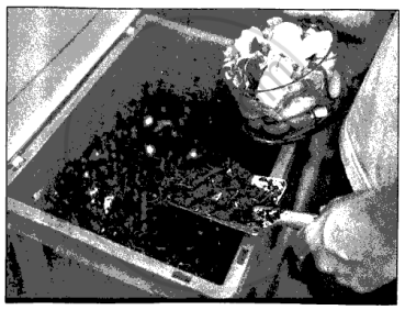
- Name the waste management practice shown in the given picture.
- State two benefits of this waste management practice.
Chapter:
Udit wants his younger sister to bring about a few lifestyle changes to help her contribute towards a cleaner and healthier environment. Suggest three advice that Udit may provide her in this regard.
Chapter:
Give a reason for the following:
Waste should be segregated before disposal.
Chapter:
Give a reason for the following:
Dumping could be harmful for the environment.
Chapter:
Give a reason for the following:
Radioactive waste is the most harmful waste.
Chapter:
Other Solutions
Submit Question Paper
Help us maintain new question papers on Shaalaa.com, so we can continue to help studentsonly jpg, png and pdf files
CISCE previous year question papers ICSE Class 10 Geography with solutions 2025 - 2026
Previous year Question paper for CISCE ICSE Class 10 -2026 is solved by experts. Solved question papers gives you the chance to check yourself after your mock test.
By referring the question paper Solutions for Geography, you can scale your preparation level and work on your weak areas. It will also help the candidates in developing the time-management skills. Practice makes perfect, and there is no better way to practice than to attempt previous year question paper solutions of CISCE ICSE Class 10 .
How CISCE ICSE Class 10 Question Paper solutions Help Students ?
• Question paper solutions for Geography will helps students to prepare for exam.
• Question paper with answer will boost students confidence in exam time and also give you an idea About the important questions and topics to be prepared for the board exam.
• For finding solution of question papers no need to refer so multiple sources like textbook or guides.
