Advertisements
Chapters
1: Interpretation of Topographical Maps
2: Contours
3: Scales and Direction
▶ 4: Map Reading and Interpretation
5: Map of India
PART II - GEOGRAPHY OF INDIA
6: Location, Extent and Physical Features
7: Climate
8: Soil Resources
9: Natural Vegetation
10: Water Resources
11: Mineral Resources
12: Conventional Sources of Energy
13: Non-Conventional Sources of Energy
14: Agriculture - I
15: Agriculture - II: Food Crops
16: Agriculture - III: Cash Crops (1)
17: Agriculture - IV: Cash Crops (2)
18: Manufacturing Industries (Agro-Based)
19: Mineral Based Industry
20: Transport
Chapter 21: Waste Management - I: Impact of Waste Accumulation
Chapter 22: Waste Management - II: Safe Disposal of Waste
![Morning Star solutions for टोटल जियोग्राफी [अंग्रेजी] कक्षा १० आईसीएसई chapter 4 - Map Reading and Interpretation - Shaalaa.com](/images/total-geography-english-class-10-icse_6:9033996325ef4d37a61a084b4444e2b2.jpg "Morning Star solutions for टोटल जियोग्राफी [अंग्रेजी] कक्षा १० आईसीएसई chapter 4 - Map Reading and Interpretation")
Advertisements
Solutions for Chapter 4: Map Reading and Interpretation
Below listed, you can find solutions for Chapter 4 of CISCE Morning Star for टोटल जियोग्राफी [अंग्रेजी] कक्षा १० आईसीएसई.
Morning Star solutions for टोटल जियोग्राफी [अंग्रेजी] कक्षा १० आईसीएसई 4 Map Reading and Interpretation EXERCISES [Pages 36 - 46]
Short Answer Questions
State what is indicated by the following symbol about the land use:
Tanks and canals
State what is indicated by the following symbol about the land use:
Open scrub
State what is indicated by the following symbol about the land use:
Stony waste
State what is indicated by the following symbol about the land use:
Causeway
Where are the thickly settled areas located in a village?
What does a dendritic drainage pattern indicate about the land?
How can the climate of a place be inferred from the topo-sheet?
What are the factors that affect settlements in an area?
Match the following physical features with the numbers on the extract of the toposheet:
- Dry river bed
- Saddle
- Steep Slope
- Pass
- Gap
- Gully
- Knoll
- Hill

Topo-sheets (Solved)
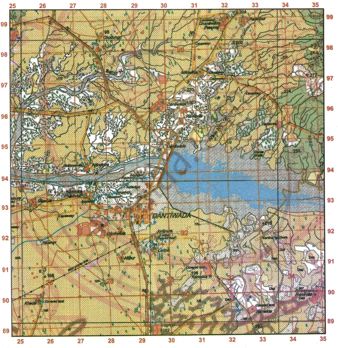
Study the extract of the Survey of India Map Sheet No. G43S7 and answer the following questions [Eastings 25-35, Northings 89-99]:

-
- Give the four-figure grid reference of the settlement of Nilpur.
- Give the six-figure grid reference of Chhatri north of Vadavas.
-
- State the compass direction of the settlement of Ratanpur from the settlement of Marwada.
- State two advantages that Dantiwada, south of river Banas has over other settlements in the region in the given map extract.
-
- What are the brown dotted clusters in the southern part of the given map extract? Also state what the letters Dep in the same area indicate.
- Explain why some of the streams in the south-eastern part of the given map extract do not join the main river? Name the settlement where these streams can be seen.
-
- What is the general pattern of human habitation (settlement) in the given map extract?
- Measure the length of the aqueduct in metres from the point whose six-figure grid reference is 261920 to the point whose six-figure grid reference is 274929.
-
- Name the two types of dams shown in the given map extract.
- How does the drainage pattern in grid square 2698 differ from the pattern of streams in grid square 2697?
Study the extract of the Survey of India map Sheet No. G43S7 and answer the following questions: [Eastings 25-35, Northings 89-99]:
-
- Give the four-figure grid reference of the settlement at Lodpa.
- Give the six-figure grid reference of the spot height •172.
-
- Identify the features from the conventional signs, the six-figure grid reference of which is 332963.
- Give the compass direction of Ramsida from Nandotra.
-
- Measure the length in kilometres of the masonry dam on the main river in the given map extract.
- Identify the type of road that runs from the Police Station at Dantiwada up to the settlement at Nandotra (Brahmanvas) (grid square 2794). For which purpose is this road used?
-
- Calculate the area of the region in sq. km, enclosed within the Eastings 25-35 and Northings 91 to 95.
- State the three types of roads seen in the given map extract. What do they reflect on the type of settlements in the region in the given map extract?
-
- State the difference in the pattern of settlement at Dantiwada on the right bank of the main river and the one on the left bank of it.
- What is the main form of irrigation in the area north of Sarod Nala? From what can you infer this source of irrigation?
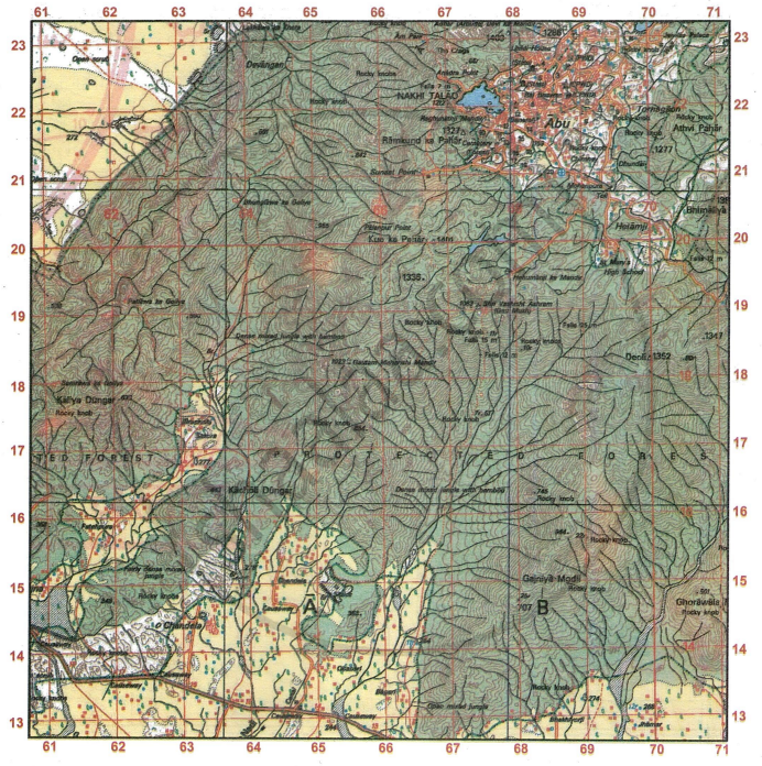
Study the extract of the Survey of India Map Sheet No. G43S10 and answer the following questions [Eastings 61-71, Northings 13-23]:
-
- Give the four-figure grid reference of the perennial well to the north of Jhamar.
- Give the six-figure grid reference of the temple at Shri Vashisht Ashram.
-
- What is the area in kilometres of the forested region enclosed within Eastings 66 and 71 and Northings 15 and 19?
- What is the compass direction of Hanumanji ka Mandir from Gautam Maharishi Mandir?
-
- What does the word ‘Falls 15m’ in grid square 6718 indicate? Explain how these falls are formed.
- What is the distance, in kilometres along the metalled road from distance stone 16 (grid square 6313) to the canal in grid square 6413?
-
- Abu is a big settlement with high water demand. From where does it get its main water supply? Give two reasons to support your answer.
- What is indicated by the large number and the closeness of the contour lines in the given map extract?
-
- What do the broken black lines in grid square 6221 indicate? How are they formed?
- Why are there no settlements except Abu in the given map extract? Give a reason to support your answer.
Study the extract of the Survey of India Map Sheet No. G43S10 and answer the following questions [Eastings 61-71, Northings 13-23]:

-
- Give the four-figure grid reference of the settlement of Deoli.
- Give the six-figure grid reference of the surveyed tree 277.
-
- What is the area in kilometres of the administrative area enclose within the Eastings 68 and 70 and the Northings 21 and 23?
- What is the compass direction of St. Mary’s High School from Gautam Maharishi Mandir?
-
- What is the distance in kilometres along the metalled road from Hanumanji ka Mandir till it merges with another metalled road in grid square 6820.
- How can you conclude that Abu is an administrative area? Give a reason to support your answer.
-
- What is meant by •501 in grid square 6421.
- How can you conclude that the yellow area in the south-east corner of the map is an agricultural land?
-
- How is the drainage pattern in grid square 6220 differ from the I drainage pattern in grid square 6817?
- What is the difference between the slope in grid square 6320 and the one in 6622? Give a reason to support your answer.
Topo-sheets (For Practice)
Study the extract of the Survey of India Map Sheet No. G43S10 and answer the following questions [Eastings 47-57, Northings 13-23]:
- Give the four-figure grid reference of
- the centre of the dry tank located to the north of Makawal.
- the highest point on the given map extract.
- the settlement of Karaunti.
- Name and give the six-figure grid reference of:
- the medical facility at Makawal.
- 5r at the confluence of Sipu Nadi and Sukli Nadi.
- the temple at Marol.
- the perennial lined well at the settlement of Goreli.
- State the compass direction of
- Was from Dolpura.
- Sibhrakhera from Rampurakhera.
- Rampurakhera from Sibhrakhera.
- Find the distance in km along the cart-track going south-west from Mitan (the point where three cart-tracks meet in grid square 5021) where it meets be the metalled road in grid square 5218.
- On which bank of Sukli Nadi lies:
- Butri
- Padrugarh
- Name the two settlements which have an Ayurvedic dispensary.
- State the reason for a number of causeways in the given map extract.
- Suppose you walk along the metalled road at a speed of 1 kilometer per hour from grid square 5517 to the distance stone numbered 29, how much time will you take to reach your destination? Write your answer in hours and minutes.
- Find the length, in kilometres of the canal between the sluice 7r and rocky knob in grid square 4717.
- Measure the direct distance in kilometers, from the chhatri in the grid square 4915 to the temple in the grid square 4717.
- What is the area in square km of the region enclosed within Eastings 52 to 55 and Northings 14 and 17.
- Give a reason for each of the following:
- Broken ground along the banks of Sipu river.
- Fairly dense scrub vegetation in the south-east part of the given map extract.
- State the occupations followed by the people at Dattani. Give reasons to support your answer.
- Explain the following terms:
- Stony Waste
- Causeway
- What difference do you notice in the drainage patterns between the streams in grid square 5315 and the streams in grid square 5119?
- Describe the drainage pattern in grid square 5117.
- What does 7r indicate in the grid square 5015 and 3r shown in the grid square 5514?
- What is an ‘Open jungle’? What does it show about the rainfall in the region on the given map extract?
- Explain one relief feature indicated by contour lines in grid square 5417.
- What are the probable occupations followed by the people living in the area shown in the given map extract?
- From where does the settlement of Dhavli get its water. Give a reason to support your answer.
- Name the prominent settlement in this extract. Give reasons to support your answer.
Study the extract of the Survey of India Map Sheet No. G43S10 Map 4 and answer the following questions [Eastings 47-57, Northings 24-34]:
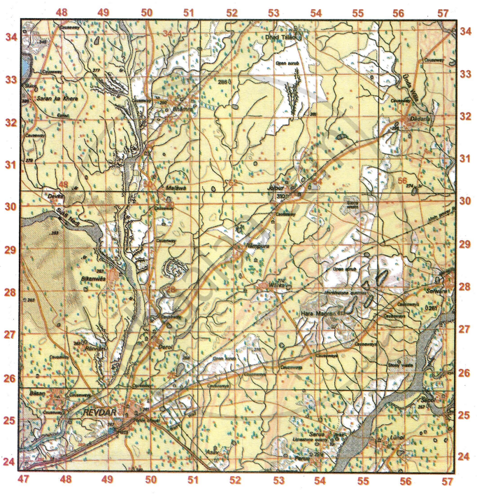
- Give the four-figure grid reference of
- the settlement of Dadarla
- Δ413
- Dispensary
- Bhamra
- Give the six-figure grid reference of
- the temple at Malawa.
- the temple at Sapol.
- the Brick Kiln at Serua.
- the surveyed tree North-East of Bhamra
- Give the compass direction of
- Revdar from Jolpur
- Rampura from Malawa
- Warka from Bhamra
- Derol from Rannari
- What are the following:
- •348 in grid square 4733.
- 6r in grid square 4828.
- 3r in grid 5630
- 286 in grid 5132
- Measure the distance in km of the unmetalled road from grid square 5031 to grid square 5233.
- What is the general pattern of drainage in the given map extract? Where is this kind of pattern usually found?
- What is the nature of streams and tanks spread over the region in the given map extract? What does the broken ground along the banks of the streams indicate?
- What is the principal means of irrigation used in the region in the given map extract? Draw the conventional symbol used for it on the maр.
- Explain the meaning of the following:
- Marblestone quarries.
- Brick

- Write a short note on the settlement Jolpur.
- Calculate the distance in km of the metalled road from Warka that intersects another metalled road in grid square 5326.
- Besides agriculture, state other probable occupations followed by people in Revdar.
- Calculate the area of the region enclosed within Eastings 47 to 50 and Northings 27 to 30.
- Name one man-made feature in grid square 5333 and one natural feature in grid square 4932.
- Name two features which make Revdar an important settlement in the given map extract.
- State any four probable occupations followed by the people of the region in the given map extract.
- What type of road exists between Malawa and Rampura? Is there an alternate route? Which route would you take?
- What is the R.F. of this map? What does it mean?
- List two occupations of the people at Serua.
- You are staying at PWD guest house at Revdar. How much distance would you travel by road to visit the temple of your family deity at the grid 4727?
Study the extract of the Survey of India Map Sheet No. G43S10 Map 5 and answer the following questions [Eastings 60-70, Northings 26-36]:
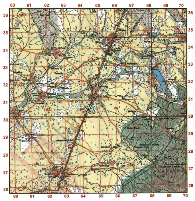
- Give the four-figure grid reference of
- Anadra Police Chauki
- Annual Fair grounds at Malgaon
- The temple at Pithapura
- The settlement at Hathal
- Give the six-figure grid reference of
- the dry tank with embankment (6r) near the fire line.
- the highest point in the extract
- the veterinary hospital at Anadra
-
- State the compass direction of Udwariya from Gulabganj.
- Mention one striking difference between these two settlements.
- Which type of road connects Anjini Devi ka Mandir till the boundary of forest? Give the four-figure grid reference where this type of road is also found. How far this temple from Moti Talao?
- Find the direct distance in km between the metalled road from NH-168 grid square 6432 and the Post Office in grid square 6233.
- What is the general direction of the flow of Sipu Nadi in the given map extract? What is the white patch (in grid square 6632) in its river bed?
- ‘Anadra is better developed settlement than Gulabganj’. Give two reasons to support your answer.
- On which bank of Sipu Nadi is the Gulabganj situated? From where does Gulabganj get its supply of water?
- State the difference in contour lines in grid squares 6726 and 6826. What does this difference show?
- In what way does the pattern of drainage in grid square 6728 differ from that in grid square 6034?
- Which settlement is better developed than other settlements in the given map extract? Give reasons to support your answer.
- What is meant by the term Fire Line? Account for the necessity of fire lines in the jungle area of the given map extract.
- Give the meaning of the following:
- 3r in grid square 6227
- •437 in grid square 6729.
- What main purpose is served by most of the wells in grid square 6232?
- What is a Diggi? Give the four figure references of any two in the extract.
- Madhav stays near Anadra. His cow is sick so he goes to the veterinary hospital at Anadra. He is told that the medical team have gone to the hospital south of Wahan. How much distance does he need to travel to get medical aid for his cow?
- Arjun is visiting his grandmother at Sirori after 20 years. List any two signs to show that the settlement has progressed.
- Write a note on the drainage pattern in the extract.
- Meena wants to attend the Annual Fairs. When and where should she visit to do so? How much distance would she have to travel between the two settlements?
- What conditions at a settlement would be conducive for the setting up of Ayurvedic medical facilities?
Study the extract of the Survey of India Map Sheet No. G43S7 Map 6 and answer the following questions [Eastings 21-31, Northings 90-02]:
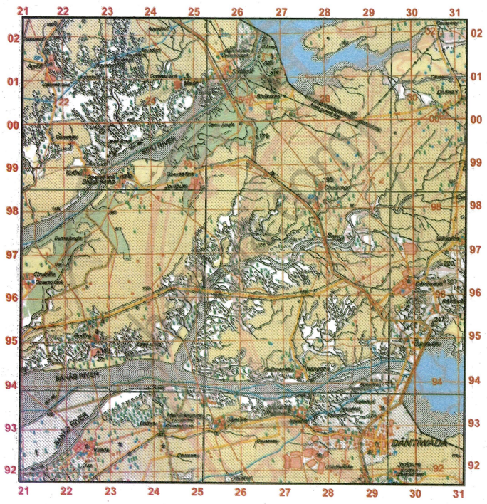
- Give the four-figure grid reference of the settlement with
- Δ179
- Sheet Rock
- the settlement of Chatrala.
- the settlement of Bhakodar
- Give the six-figure grid reference of the following:
- Surveyed tree at Godh.
- Overhead tank at Bhakodar.
- Covered tank at Meda.
- Lined well of 25 m depth south of Chodungri.
- Triangulated height 179
- What is the compass direction of
- Bhakodar from Jorapura.
- Dhaneri from Sikariya.
- Sodapur from Bhadli Kotha.
- Godh from Bhakodar
- Which type of road joins Vasda with Latiya and which type of road joins Agdol with Bhadli Kotha?
- Sarod Nala is a tributary of which river? On which bank it joins the main river?
- There are two types of dams on Banas river at Dantiwada. State the difference between these two dams.
- Give a reason for the presence of each of the following in the given map extract:
- Broken land along the banks of rivers
- Causeways
- Aqueduct
- How does the powerline at Sodapur differ from that at Marwada?
- Name two man-made features in grid square 2601.
- What do the following mean?
- 25r in grid square 2798.
- Δ166 in grid square 2294.
- State the two types of dams shown in the given map extract.
- Calculate the area in sq.km. between the Eastings 24 to 29 and Northings 95 to 99.
- What is the difference in settlement pattern between Jorapura on the left bank of Sipu river and the settlement of Atal?
- Explain the meaning of the following:
- Sheet Rock
- Δ307
- Sluice
- Aqueducts
- Why is the region on the left bank of Sipu river not cultivable?
- What is the general pattern of settlements in the region shown in the given map extract? Give a reason to support your answer.
- Explain the type of drainage pattern found in grid square 2698.
- Are the settlements in the region in the given map rural or urban? Give a reason to support your answer.
-
- What does the black dots in the bed of Sarod Nala indicate?
- What is the general direction of flow of the Sarod Nala? What type of river is Sarod Nala?
- State the modes of irrigation used at important settlements in the region in the given map extract.
Study the extract of the Survey of India Map Sheet No. G43S7 Map 7 and answer the following questions [Eastings 28-38, Northings 02-12]:
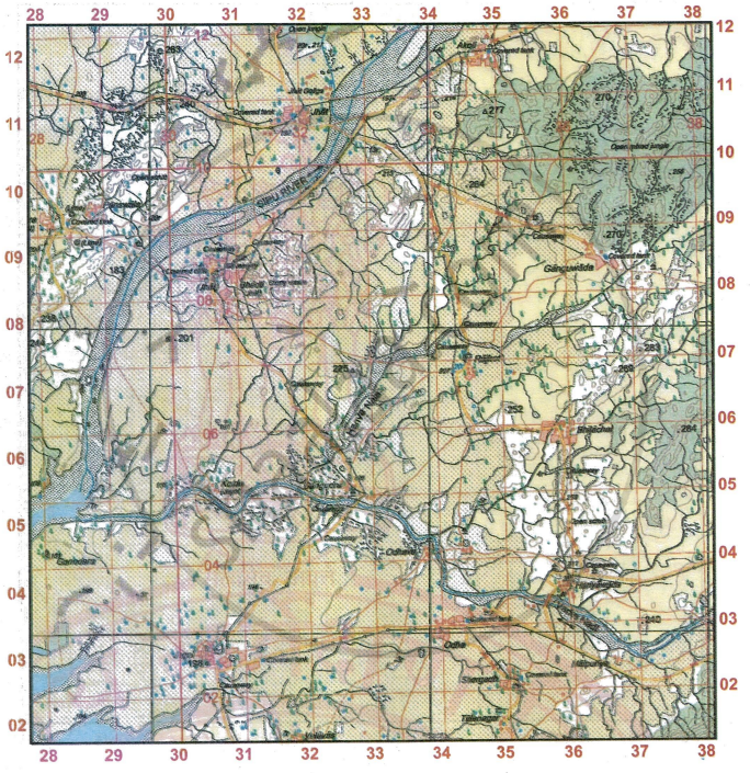
- Give the four-figure grid reference of
- the confluence of Sipu river and Varka Nadi.
- the settlement at Odhava
- the stony waste Bhadli
- the settlement at Akoli
- Give the six-figure grid reference of:
- Δ225
- A lined well near Ganguwada
- the highest point in the extract
- the temple at Bhadli
- What is the compass direction of the settlement of Panswala from the settlement of Kotda.
-
- What is the general direction of flow of Varka Nadi?
- What does the blue line in the Varka Nadi indicate?
- What does 5r in the grid square 2903 mean?
- How many types of road are shown in the given map extract?
- In which part of the given map extract people have taken up agriculture as the main occupation? Give a reason to support your answer.
- Calculate the distance in km along the metalled road between Ganguwada and the place where the road intersects with another metalled road in grid square 3309.
- Name two types of vegetation in the given map extract. Where are they found?
- What are the white patches in the given map extract? Also state what are the black broken lines along the river banks.
- What is the general pattern of settlements in the region in the given map extract?
- Give two reasons to show that the area depicted in the given map extract experiences seasonal rainfall.
- What do figures 1:50,000 printed in the legend of a map extract mean?
- Write a note on Hanva Nala with reference to the Varka Nadi and the farmer’s confluence with the latter.
- List two occupations other than agriculture of the people at Bhadli.
- Deven has to travel from Jhat to Rajkot. When would he reach Rajkot if he travels at 5 km/hr? Comment on the types of roads he would have to travel through.
- Rajender wants to visit as many temples as he can visit in this extract by car [Hint: On metalled roads only]. Give the four figure references of the temples he can visit as well as his route plan.
- What do you understand by open mixed jungle? What does the broken ground in it signify?
- What are the probable occupations of the people living in Panswala. Give reasons to support your answer.
- What is the difference between •270 and Δ277?
Study the extract of the Survey of India Map Sheet No. G43S7 Map 8 and answer the following questions [Eastings 36-46, Northings 85-95]:
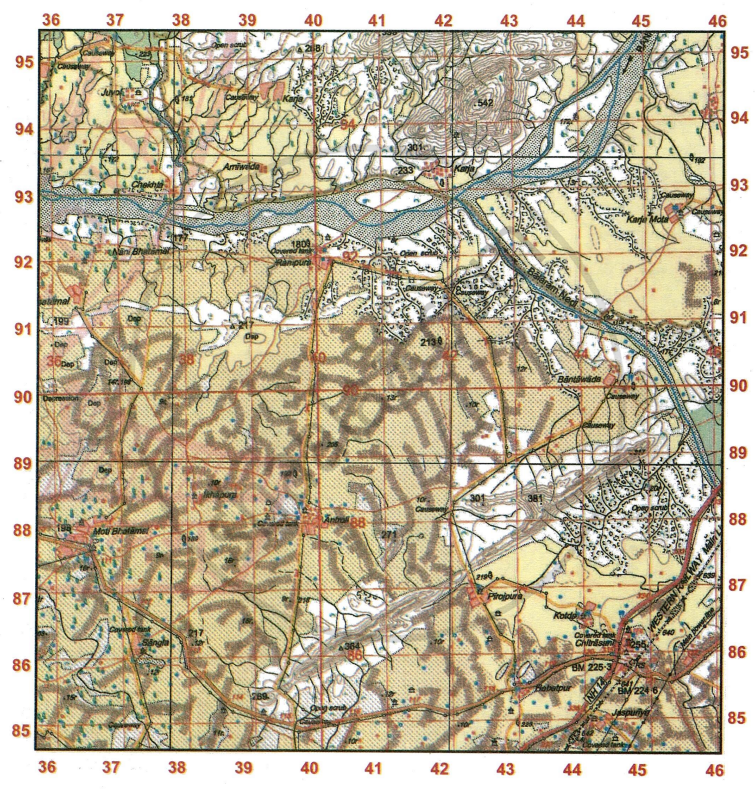
- Give the four-figure grid reference of a settlement with
- Spot height •233.
- Post Office.
- Spot height 301.
- Δ364
- Give the six-figure grid reference of
- An overhead tank at Karja Mota.
- A temple north of Rampura.
- the spot height that marks the highest point in the extract.
- the surveyed tree south of Ikhapura.
- State the compass direction of
- Arniwada from Juvol
- Antroli from Kotda
- Chekhla from Rampura
- Sangla from Bantawada
- What do the Spot heights •301 (grid square 4193) and •269 (grid square 3985) represent?
- In the given map extract, in which course of its journey is the Banas river? Give a reason to support your answer.
- Name two man-made features in grid square
- 4185
- 4592
- State two features of the Western Railway as shown in the map extract.
- Give a reason for each of the following:
- There are few settlements on the banks of the main river in the given map extract.
- A number of streams after flowing for short distances, disappear.
- State the features that make Chitrasani an important settlement in the region.
- What is the direction of flow of Balaram Nadi? What does the black dots in the river bed indicate?
- What do the contour lines between grid square 3985 and 4186 represent?
- What do the following mean?
- Open scrub in grid square 4192.
- The tree marked 192 in grid square 3988.
- 8r in grid square 4192.
- Δ364 in grid square 4086.
- How are the gentle and steep slopes shown on the map?
- State two main sources of water at the settlement of Antroli.
- Despite the presence of metalled roads and electricity, why are there no big settlements in the region?
- Calculate the area in sq. kms within the Eastings 40 to 44 and Northings 85 to 89.
- What do you understand by open scrub? What does the white colour on the extract signify?
- What do the reddish closely placed dots covering the most of the extract signify? Comment on the land usage where the lines are present.
- Sanjay needs to go from the covered tank at Sangla to that at Antroli. What types of road would he take? How much distance would he travel?
- What is the total area of the actual ground represented in the map extract? Show the calculation you have made.
Solutions for 4: Map Reading and Interpretation
Morning Star solutions for टोटल जियोग्राफी [अंग्रेजी] कक्षा १० आईसीएसई chapter 4 - Map Reading and Interpretation
Shaalaa.com has the CISCE Mathematics टोटल जियोग्राफी [अंग्रेजी] कक्षा १० आईसीएसई CISCE solutions in a manner that help students grasp basic concepts better and faster. The detailed, step-by-step solutions will help you understand the concepts better and clarify any confusion. Morning Star solutions for Mathematics टोटल जियोग्राफी [अंग्रेजी] कक्षा १० आईसीएसई CISCE 4 (Map Reading and Interpretation) include all questions with answers and detailed explanations. This will clear students' doubts about questions and improve their application skills while preparing for board exams.
Further, we at Shaalaa.com provide such solutions so students can prepare for written exams. Morning Star textbook solutions can be a core help for self-study and provide excellent self-help guidance for students.
Concepts covered in टोटल जियोग्राफी [अंग्रेजी] कक्षा १० आईसीएसई chapter 4 Map Reading and Interpretation are Map Reading, Primary Information or Marginal Information, Relationship Between Physical Features and Human Activities, Analysis of Topo-sheet No. G43S7, Analysis of Topo-sheet No. G43S10, Representation of Relief Features, Elements of a Map, Types of Maps, Various Levels of Topographical Maps Based on Different Scales, Map Scale, Grid Reference, Methods of Representation of Relief on the Map > Hill Shading, Methods of Representation of Relief on the Map > Contours, Relationship Between Physical Features and Human Activities, Analysis of Topo-sheet No. G43S7, Analysis of Topo-sheet No. G43S10, Occupation, Settlement Pattern, Natural Vegetation, Human-Made and Natural Features, Topographic or Ordnance Survey Maps, National Grid Reference, Conventional Signs and Symbols used in Topographical Maps, River Features and Drainage Pattern in a Topographical Map, Representation of Relief Features, Methods of Representation of Relief on the Map > Hachures, Identification of Landforms Marked by Contours, Measurement of Distances on a Map, Means of Irrigation and Other Water Features in a Topographical Map, Direction, Representation of Heights in · Topographical Map, Map Reading, Primary Information or Marginal Information, Contour Diagrams, The Stages of the River, Structure of Topographical Map, Introduction to Topographical Maps and Their Significance, Elements of a Map, Types of Maps, Various Levels of Topographical Maps Based on Different Scales, Map Scale, Grid Reference, Methods of Representation of Relief on the Map > Hill Shading, Methods of Representation of Relief on the Map > Contours, Relationship Between Physical Features and Human Activities, Analysis of Topo-sheet No. G43S7, Analysis of Topo-sheet No. G43S10, Occupation, Settlement Pattern, Natural Vegetation, Human-Made and Natural Features, Topographic or Ordnance Survey Maps, National Grid Reference, Conventional Signs and Symbols used in Topographical Maps, River Features and Drainage Pattern in a Topographical Map, Representation of Relief Features, Methods of Representation of Relief on the Map > Hachures, Identification of Landforms Marked by Contours, Measurement of Distances on a Map, Means of Irrigation and Other Water Features in a Topographical Map, Direction, Representation of Heights in · Topographical Map, Map Reading, Primary Information or Marginal Information, Contour Diagrams, The Stages of the River, Structure of Topographical Map, Introduction to Topographical Maps and Their Significance.
Using Morning Star टोटल जियोग्राफी [अंग्रेजी] कक्षा १० आईसीएसई solutions Map Reading and Interpretation exercise by students is an easy way to prepare for the exams, as they involve solutions arranged chapter-wise and also page-wise. The questions involved in Morning Star Solutions are essential questions that can be asked in the final exam. Maximum CISCE टोटल जियोग्राफी [अंग्रेजी] कक्षा १० आईसीएसई students prefer Morning Star Textbook Solutions to score more in exams.
Get the free view of Chapter 4, Map Reading and Interpretation टोटल जियोग्राफी [अंग्रेजी] कक्षा १० आईसीएसई additional questions for Mathematics टोटल जियोग्राफी [अंग्रेजी] कक्षा १० आईसीएसई CISCE, and you can use Shaalaa.com to keep it handy for your exam preparation.
