Advertisements
Advertisements
प्रश्न
Study the extract of the Survey of India Map Sheet No. G43S7 Map 6 and answer the following questions [Eastings 21-31, Northings 90-02]:
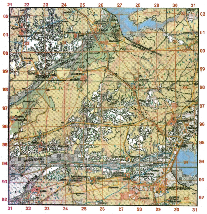
- Give the four-figure grid reference of the settlement with
- Δ179
- Sheet Rock
- the settlement of Chatrala.
- the settlement of Bhakodar
- Give the six-figure grid reference of the following:
- Surveyed tree at Godh.
- Overhead tank at Bhakodar.
- Covered tank at Meda.
- Lined well of 25 m depth south of Chodungri.
- Triangulated height 179
- What is the compass direction of
- Bhakodar from Jorapura.
- Dhaneri from Sikariya.
- Sodapur from Bhadli Kotha.
- Godh from Bhakodar
- Which type of road joins Vasda with Latiya and which type of road joins Agdol with Bhadli Kotha?
- Sarod Nala is a tributary of which river? On which bank it joins the main river?
- There are two types of dams on Banas river at Dantiwada. State the difference between these two dams.
- Give a reason for the presence of each of the following in the given map extract:
- Broken land along the banks of rivers
- Causeways
- Aqueduct
- How does the powerline at Sodapur differ from that at Marwada?
- Name two man-made features in grid square 2601.
- What do the following mean?
- 25r in grid square 2798.
- Δ166 in grid square 2294.
- State the two types of dams shown in the given map extract.
- Calculate the area in sq.km. between the Eastings 24 to 29 and Northings 95 to 99.
- What is the difference in settlement pattern between Jorapura on the left bank of Sipu river and the settlement of Atal?
- Explain the meaning of the following:
- Sheet Rock
- Δ307
- Sluice
- Aqueducts
- Why is the region on the left bank of Sipu river not cultivable?
- What is the general pattern of settlements in the region shown in the given map extract? Give a reason to support your answer.
- Explain the type of drainage pattern found in grid square 2698.
- Are the settlements in the region in the given map rural or urban? Give a reason to support your answer.
-
- What does the black dots in the bed of Sarod Nala indicate?
- What is the general direction of flow of the Sarod Nala? What type of river is Sarod Nala?
- State the modes of irrigation used at important settlements in the region in the given map extract.
स्पष्ट कीजिए
कारण बताइए
विस्तार में उत्तर
Advertisements
उत्तर
-
- 2699
- 2500
- 2196
- 2600
- 2994
-
- 227952
- 253003
- 245000
- 277982
- 264996
-
- North-East
- Dhari
- North-East
- South-West
- Vasda with Latiya - Unmettaled road and Agdol with Bhadli Kotha - Metalled road
- Sarod Nala is a tributary of Banas River. It joins the main river on right bank.
-
- Black colour dam: It is the Earth dam which is constructed of the material such as gravels, broken weathered rocks, sand, silt or soil.
- Red colour dam: It is the Masonry dam with embankment. These dams are made up of stone and bricks. These dams are sometimes joined with mortar.
-
- It is due to alterate wet and dry periods.
- It indicates seasonal rainfall. In rainy seasons, the minor streams get flooded. In order to cross the minor streams, causeways are built.
- It is an artificial pipeline to carry water from one place to another.
- The powerline of Sodapur is Surveyed pylon power lines whereas at it is unsurveyed power line.
- The man made feature in grid square 2601 : Lime kiln and embankment of earthen dam.
-
- Relative depth of perennial lined well is 25 m.
- It is triangulated height.
- Earthen Dam and Masonry Dam
- No. of Easting = 5
No. of Northing = 4
Area = 5 × 4 = 20 sq. km - The settlement pattern at Jorapura number of sheet is Nucleated whereas the settlement of Atal is scattered.
-
- Sheet rock: The term ‘sheet rock’ is commonly used to refer to gypsum board or drywall, which is a panel made of calcium sulfate dihydrate (gypsum) with or without additives and normally pressed between a facer and a backer. It is widely used in the construction industry as a material for making interior walls and ceilings.
- Δ307: Without additional context, it's challenging to determine the specific meaning of “D307.” It could refer to a product code, a specification, or some other identifier within a particular context. If you provide more information or context, I may be able to help you better.
- Sluice: A sluice is a water channel or conduit used to control the flow of water, typically for the purpose of conveying, diverting, or controlling the movement of water. Sluices are commonly used in mining to separate valuable minerals from the surrounding gravel or sediment by allowing water to flow through a channel, carrying away lighter materials while leaving behind the heavier minerals.
- Aqueducts: Aqueducts are artificial channels, often elevated on arches or supported structures, designed to transport water from one place to another. They have been historically crucial for supplying cities and agricultural areas with water for drinking, irrigation, and other purposes. Aqueducts can be elaborate systems of channels, pipes, and bridges, showcasing advanced engineering and architectural techniques.
- It is because of the presence of the broken ground.
- The general pattern of the settlement is Nucleated as the permanent huts are located very close to one another. They are compact.
- Drainage pattern in grid square 2698 is Rectangular.
- The settlements given in the map extract belongs to rural region as the main occupation of the people in the map extract is farming.
-
- It indicates the sediments deposited on the bed of the river.
- North east to South West.
- Mode of irrigation - perennial lined wells, presence of aqueduct.
Important settlement - Dantiwada.
shaalaa.com
क्या इस प्रश्न या उत्तर में कोई त्रुटि है?
