Advertisements
Advertisements
प्रश्न
Study the extract of the Survey of India Map Sheet No. G43S7 Map 7 and answer the following questions [Eastings 28-38, Northings 02-12]:
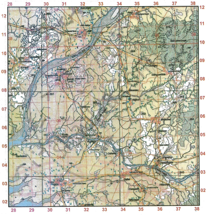
- Give the four-figure grid reference of
- the confluence of Sipu river and Varka Nadi.
- the settlement at Odhava
- the stony waste Bhadli
- the settlement at Akoli
- Give the six-figure grid reference of:
- Δ225
- A lined well near Ganguwada
- the highest point in the extract
- the temple at Bhadli
- What is the compass direction of the settlement of Panswala from the settlement of Kotda.
-
- What is the general direction of flow of Varka Nadi?
- What does the blue line in the Varka Nadi indicate?
- What does 5r in the grid square 2903 mean?
- How many types of road are shown in the given map extract?
- In which part of the given map extract people have taken up agriculture as the main occupation? Give a reason to support your answer.
- Calculate the distance in km along the metalled road between Ganguwada and the place where the road intersects with another metalled road in grid square 3309.
- Name two types of vegetation in the given map extract. Where are they found?
- What are the white patches in the given map extract? Also state what are the black broken lines along the river banks.
- What is the general pattern of settlements in the region in the given map extract?
- Give two reasons to show that the area depicted in the given map extract experiences seasonal rainfall.
- What do figures 1:50,000 printed in the legend of a map extract mean?
- Write a note on Hanva Nala with reference to the Varka Nadi and the farmer’s confluence with the latter.
- List two occupations other than agriculture of the people at Bhadli.
- Deven has to travel from Jhat to Rajkot. When would he reach Rajkot if he travels at 5 km/hr? Comment on the types of roads he would have to travel through.
- Rajender wants to visit as many temples as he can visit in this extract by car [Hint: On metalled roads only]. Give the four figure references of the temples he can visit as well as his route plan.
- What do you understand by open mixed jungle? What does the broken ground in it signify?
- What are the probable occupations of the people living in Panswala. Give reasons to support your answer.
- What is the difference between •270 and Δ277?
कारण बताइए
विस्तार में उत्तर
Advertisements
उत्तर
-
- 305080
- 343081
- 369068
- 365034
-
- 2588
- 2394
- 2988
- 2891
- North-east
-
- Generally westward (flows from east toward the west).
- The solid blue line shows the main (perennial) river channel, i.e., the river’s flowing channel.
- “5r” means a relative height of 5 metres, i.e., the feature (usually an embankment/bund or raised bank) is 5 m higher than the surrounding ground. This is the SOI convention where a number followed by ‘r’ gives a relative height (not elevation above sea level).
- Three. The extract shows metalled roads, cart-tracks and pack-tracks.
-
- In the southern and central parts of the map extract.
- Reason: these areas show extensive yellow wash (cultivated land) with wells and irrigation features, indicating agriculture as the main occupation.
- 1.6 km.
-
- Wooded land (green wash/forest) - shown on the map mainly in the hilly/northeastern sector
- Open scrub (scrubland) - occurs as scattered patches and on poorer/rocky ground in the lower/south‑western parts of the extract.
- The white patches are areas of uncultivated (waste/bare) land. The black broken (dashed) lines along the river banks indicate broken ground (eroded/broken land along the river).
- Predominantly nucleated (clustered) settlements concentrated along the rivers and metalled roads, with some linear development along main roads and larger villages at road/river junctions; scattered/isolated hamlets occur near stony waste and upland areas.
-
- Presence of many water‑storage and irrigation structures (tanks, lined/covered wells, sluices, causeways): these are man‑made features built to collect and store monsoon water for use in the dry months, which indicates dependence on a seasonal rainfall supply.
- Natural/physical evidence of seasonal flow, numerous small nalas/seasonal streams, sand‑banked/braided river reaches and areas of stony waste/open scrub/broken ground: these features show rivers and watercourses that run strongly in wet season but reduce or dry up later, and vegetation adapted to a dry period.
- “1:50,000” is the representative fraction (map scale), it means 1 unit on the map equals 50,000 of the same units on the ground. For example, 1 cm on the map = 50,000 cm on the ground = 500 m; 2 cm on the map = 1 km.
- Hanva Nala is a small seasonal (ephemeral) tributary shown on the map that drains local higher ground and joins the Varka Nadi within the map extract. At its junction with the Varka Nadi there is a farmer’s confluence, a local, small-scale diversion/point where farmers take off water (and/or have made bunds/sluices) to irrigate nearby fields. Thus Hanva Nala contributes runoff to the Varka Nadi during the rainy season and provides short-term irrigation benefits, but remains largely dry or low in flow outside the monsoon.
- Cattle rearing (pastoralism) and stone‑quarrying/stone cutting.
-
- Deven would reach Rajkot in about 4 hours if he travels at a speed of 5 km per hour (distance is approximately 20 km as measured on the map using the scale).
- Type of roads: He would have to travel mainly through metalled roads, along with some stretches of unmetalled roads/cart tracks shown on the map.
- Rajender should start from Jhat (3008) → travel eastwards on the metalled road to Chitra (3205) → continue north-east towards Ganganvada (3608) → then move south-west on the metalled road to Rajkot (3404). This route uses only metalled roads, making it suitable for travel by car.
- Open mixed jungle: a vegetation type of mixed tree species with a relatively open canopy (scattered trees, scrub and undergrowth rather than dense forest). The broken ground shown in it denotes uneven, eroded or rocky/ stony surface (gullied or scarped ground produced by erosion), i.e. rough, uncultivable terrain.
-
- Probable occupations: agriculture (crop farming) and cattle‑rearing (animal husbandry).
- Reasons: the map shows yellow wash (cultivated land) and perennial/lined wells and covered tanks used for irrigation, indicating farming is practiced. Open scrub/grassland near the settlement provides grazing for livestock, supporting cattle‑rearing; presence of settlement with cart‑tracks/metalled roads also supports rural farming activities.
- •270 = spot height (elevation 270 m). Δ277 = triangulation (trig) station (elevation 277 m). Difference in elevation = 7 m.
shaalaa.com
क्या इस प्रश्न या उत्तर में कोई त्रुटि है?
