Advertisements
Advertisements
प्रश्न
Study the extract of the Survey of India Map Sheet No. G43S7 Map 8 and answer the following questions [Eastings 36-46, Northings 85-95]:
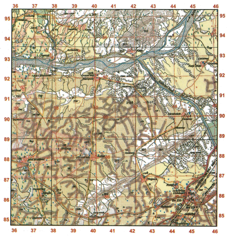
- Give the four-figure grid reference of a settlement with
- Spot height •233.
- Post Office.
- Spot height 301.
- Δ364
- Give the six-figure grid reference of
- An overhead tank at Karja Mota.
- A temple north of Rampura.
- the spot height that marks the highest point in the extract.
- the surveyed tree south of Ikhapura.
- State the compass direction of
- Arniwada from Juvol
- Antroli from Kotda
- Chekhla from Rampura
- Sangla from Bantawada
- What do the Spot heights •301 (grid square 4193) and •269 (grid square 3985) represent?
- In the given map extract, in which course of its journey is the Banas river? Give a reason to support your answer.
- Name two man-made features in grid square
- 4185
- 4592
- State two features of the Western Railway as shown in the map extract.
- Give a reason for each of the following:
- There are few settlements on the banks of the main river in the given map extract.
- A number of streams after flowing for short distances, disappear.
- State the features that make Chitrasani an important settlement in the region.
- What is the direction of flow of Balaram Nadi? What does the black dots in the river bed indicate?
- What do the contour lines between grid square 3985 and 4186 represent?
- What do the following mean?
- Open scrub in grid square 4192.
- The tree marked 192 in grid square 3988.
- 8r in grid square 4192.
- Δ364 in grid square 4086.
- How are the gentle and steep slopes shown on the map?
- State two main sources of water at the settlement of Antroli.
- Despite the presence of metalled roads and electricity, why are there no big settlements in the region?
- Calculate the area in sq. kms within the Eastings 40 to 44 and Northings 85 to 89.
- What do you understand by open scrub? What does the white colour on the extract signify?
- What do the reddish closely placed dots covering the most of the extract signify? Comment on the land usage where the lines are present.
- Sanjay needs to go from the covered tank at Sangla to that at Antroli. What types of road would he take? How much distance would he travel?
- What is the total area of the actual ground represented in the map extract? Show the calculation you have made.
कारण बताइए
विस्तार में उत्तर
Advertisements
उत्तर
-
- 4193
- 4486
- 4288
- 4086
-
- 454927
- 402923
- 424943
- 379877
-
- South-east
- North-west
- North-west
- South-west
- •301 represents the peak of the conical hill whereas •269 represents the low range peak of Col and saddle.
- Banas river is in the middle course as the river flows sluggisly forming meanders. The volume of water increases and the speed decreases.
- Two man-made features in
- 4185 - Temple, chatri, Metalled road.
- 4592 - Temple, cart track.
-
- This railway line has cutting with tunnel.
- It has pars.
-
- It is due to presence of broken ground which indicates that this region get seasonal rainfall and it gets flooded during rainy season.
- Due to the presence of sandy soil.
- It has national highway connectivity, post office, temple, perennial lined wells, covered tank, western railways lines, unsurvey power line.
- It is towards North west, it indicates the sediments or load.
-
- 3985 - col and saddle
- 4186 - Ridge, conical hill, steep slope
-
- Open scrub: It is a region of scanty rainfall where thorny bushes are grown. Cattle rearing is the main occupation.
- surveyed tree
- relative height of the river bank is 8 m.
- It indicates the triangulation height is 364 m.
- When contours are spaced far from one another at equal distance, it indicates gentle slope. When contours are placed very close to one another, it indicates steep slope.
- Perennial lined wells, covered tanks.
- Due to the presence of depresssions, broken ground and dry streams.
- No. of Easting = 4
No. of Northing = 4
Area = 4 × 4 = 16 sq. km. - Open scrub is a region of scanty rainfall where thorny bushes are grown. White colour indicates that is an uncultivated or barren land.
- It indicates the sand dunes. The region has sandy soil.
- 3 km 450m
- 100 sq km.
No. of Easting = (85 – 95) = 10
No. of Northing = (36 – 46) = 10
Area = 10 × 10 sq km = 100 sq. km
shaalaa.com
क्या इस प्रश्न या उत्तर में कोई त्रुटि है?
