Advertisements
Chapters
1: Interpretation of Topographical Maps
2: Contours
3: Scales and Direction
4: Map Reading and Interpretation
5: Map of India
PART II - GEOGRAPHY OF INDIA
6: Location, Extent and Physical Features
▶ 7: Climate
8: Soil Resources
9: Natural Vegetation
10: Water Resources
11: Mineral Resources
12: Conventional Sources of Energy
13: Non-Conventional Sources of Energy
14: Agriculture - I
15: Agriculture - II: Food Crops
16: Agriculture - III: Cash Crops (1)
17: Agriculture - IV: Cash Crops (2)
18: Manufacturing Industries (Agro-Based)
19: Mineral Based Industry
20: Transport
Chapter 21: Waste Management - I: Impact of Waste Accumulation
Chapter 22: Waste Management - II: Safe Disposal of Waste
![Morning Star solutions for टोटल जियोग्राफी [अंग्रेजी] कक्षा १० आईसीएसई chapter 7 - Climate - Shaalaa.com](/images/total-geography-english-class-10-icse_6:9033996325ef4d37a61a084b4444e2b2.jpg "Morning Star solutions for टोटल जियोग्राफी [अंग्रेजी] कक्षा १० आईसीएसई chapter 7 - Climate")
Advertisements
Solutions for Chapter 7: Climate
Below listed, you can find solutions for Chapter 7 of CISCE Morning Star for टोटल जियोग्राफी [अंग्रेजी] कक्षा १० आईसीएसई.
Morning Star solutions for टोटल जियोग्राफी [अंग्रेजी] कक्षा १० आईसीएसई 7 Climate EXERCISES [Pages 89 - 95]
Choose the correct option:
Mahabaleshwar in Maharashtra is one of the wettest place in India due to its location on a ______.
high altitude
windward slopе
Tropical Zone
leeward slope
Assertion (A): India has a tropical monsoon type of climate.
Reason (R): Its climate is influenced by the monsoon winds which are largely confined to the tropics.
Both A and R are true and R is the correct explanation of A.
Both A and R are true but R does not explain A.
A is true but R is false.
A is false but R is true.
The Western Ghats receive more rainfall from the South West monsoon than the Eastern Ghats because ______.
it lies in the way of South West Monsoon winds.
it lies in the rain-shadow area of the Himalayas.
it lies in the rain-shadow area of the Eastern Ghats.
it is triangular in shape.
What causes the winter rain along the Coromandel Coast?
Sea breeze
Retreating monsoon
South-west monsoon
Western disturbances
Assertion (A): The Himalayas form a climatic barrier separating the Indian subcontinent from the rest of Asia.
Reason (R): They are high mountain ranges with some of the world’s highest peaks.
Both A and R are true and R is the correct explanation of A.
Both A and R are true but R does not explain A.
A is true but R is false.
A is false but R is true.
Which of the following is NOT a source of rainfall for Punjab and Haryana?
Western disturbances
Arabian Sea branch of South-west monsoon
Bay of Bengal branch of South-west monsoon
Retreating monsoon
Which of the following factors does not affect the climate of a place?
Varied relief
The Monsoon Winds
Distance from the Sea
Urbanisation
Assertion (A): The Western Ghats get heavy rainfall on the western side.
Reason (R): The Western Ghats are parallel to the monsoon winds.
Both A and R are true and R is the correct explanation of A.
Both A and R are true but R does not explain A.
A is true but R is false.
A is false but R is true.
Western disturbances influence the climatic conditions in northern India during which season?
Summer
Winter
Spring
Monsoon
The summer monsoon winds blow in which direction?
North-East
South-West
North-West
South-East
The Arabian Sea Branch of the monsoon winds splits in three. Which of the following is incorrect?
Western Ghats and Western Coastal Plains.
Saurashtra Peninsula and Kutch.
Coast north of Mumbai and the Narmada and Tapi Valleys.
Coromandel coast and Odisha.
Mahendra was happy that the rains came on time and he could plant his paddy without depending on irrigation. But after a few wet days there was no rain for more than two weeks. What is this period called?
Burst of monsoon
Break of monsoon
Delayed monsoon
El Nino
Which of the following is good for the cultivation of tea and jute?
Mango showers
Loo
Kalbaisakhi
None of the above
Where does the Arabian Sea branch join the Bay of Bengal branch?
In Punjab and Haryana
In Western Ghats
In Chota Nagpur Plateau
In the Sahyadris
What causes the ‘October Heat’?
High temperature and heavy rainfall.
Reduced temperature and heavy rainfall.
High temperature and humidity.
Reduced temperature and humidity.
Assertion (A): Nagpur sees a maximum of 45°C in May which drops to 31°C in July.
Reason (R): The rains bring down the temperature.
Both A and R are true and R is the correct explanation of A.
Both A and R are true but R does not explain A.
A is true but R is false.
A is false but R is true.
Why do the interior parts of the Deccan remain dry during the Retreating monsoon?
Because they lie in the rain-shadow of the Eastern Ghats.
Because they lie parallel to the Eastern Ghats.
Because they lie in the rain-shadow of the Western Ghats.
Because they lie parallel to the Arabian Sea Branch.
The climate of India is strongly influenced by ______.
Trade winds
Loo
Easterly winds
Monsoon winds
Which of the following factors cause the rise in the temperature of mainland of India in the month of March?
The land breeze blows towards the sea.
The pressure belts shift.
Southward migration of the sun from the equator.
Northward migration of the sun from the equator.
Assertion (A): A large part of the Bay of Bengal Branch of the South West Monsoon is deflected towards the Indian Subcontinent.
Reason (R): The presence of the Arakan Hills along the coast of Myanmar.
Both A and R are true and R is the correct explanation of A.
Both A and R are true but R does not explain A.
A is true but R is false.
A is false but R is true.
The following headline was printed in a newspaper “The monsoon is set to deliver its last bout of rainfall before retreating from the region.” In which month would this be published?
June
September
October
March
Which state in India is the first to experience the onset of the monsoon and the last to see its withdrawal?
Tamil Nadu
Kerala
West Bengal
Andaman and Nicobar
Goa
Which of the following areas get rainfall from the retreating monsoon?
West Coast of India
East Coast of India
Western Ghats
Thar desert
Answer the following questions:
Name the type of climate prevailing over India. Mention any two factors responsible for it.
State two important characteristic features of the monsoon rainfall in India.
Give a geographical reason for the following:
Heatwaves in the end of April are experienced in the northern plains.
Give a geographical reason for the following:
Tropical cyclones are common in the Bay of Bengal as compared to the Arabian Sea.
Give a geographical reason for each of the following:
The Indo-Gangetic Plain gets some rainfall in the months of December and January.
What is ‘Monsoon’?
Name the place of India which gets the highest rainfall.
Mention the different sources of rain in Punjab and Tamil Nadu during the winter season.
What is meant by ‘rain-shadow area’?
Give an example and state the mountains which are responsible for the rain-shadow area.
Study the climatic data given below and answer the questions that follow:
| Month | Jan | Feb | Mar | Apr | May | June | July | Aug | Sep | Oct | Nov | Dec |
| Temperature °C | 23.1 | 24.8 | 26.5 | 29.3 | 32 | 32.8 | 33.1 | 32.1 | 30.5 | 29.3 | 28.7 | 26.1 |
| Rainfall cm | 15.3 | 10.1 | 0.3 | 0.1 | 1.3 | 4.5 | 6.1 | 10.2 | 10.5 | 20.1 | 16.8 | 19.0 |
- Calculate the annual rainfall experienced by the station.
- What can you conclude about the climate of this station - is it maritime or continental? How did you come to this conclusion?
- Name the season during which rainfall is the heaviest. Name a probable station satisfying this criteria.
Mention the geographical reason for the following:
Western Rajasthan receives no rain from the Arabian Sea branch of the South West Monsoon winds.
Mention the geographical reason for the following:
Mangalore is not cold even in the month of December.
Give a geographical reason for the following:
Even in summer Shimla is cooler than Delhi.
State two points of difference in climate between the northern and the southern zone of India due to latitude.
State briefly the impact of water bodies on the climate in coastal areas.
Give a geographical reason for the following:
Variations in the type of climate in different regions of India.
Give a geographical reason for the following:
Most parts of India receive rainfall between June and September.
Give a geographical reason for the following:
South-West Monsoon withdraw from northern India in October.
What are ‘jet streams’?
How do jet streams influence the climate of India?
How does El-Nino affect the climate of India?
State two characteristic features of North-East Monsoon.
Mention three important features of rainfall in India.
Give a geographical reason for the following:
Pune receives less rainfall than Mumbai.
Give a geographical reason for the following:
Tropical cyclones bring heavy rainfall but temperate cyclones bring light rainfall.
Give a geographical reason for the following:
Kerala has a tropical climate while Punjab has a continental climate.
Distinguish between ‘Burst of Monsoon’ and ‘Break of Monsoon’.
Define western disturbances.
Define mango showers.
Give a geographical reason for the following:
The monsoon rain is unevenly distributed over India.
Give a geographical reason for the following:
Excessive cold in north India during winter season.
Give a geographical reason for the following:
Most of the India remains dry during the North-East Monsoon season.
Name two regions which get very little rain from the summer monsoon.
Name any three local winds which blow in India and write briefly about each.
What is meant by the season of ‘retreating monsoon’?
Name the months in which retreating monsoon rain is experienced.
Give a geographical reason for the following:
The northern plains of India do not freeze in winter.
Give a geographical reason for the following:
In spite of Aravali Range, Rajasthan receives scanty rainfall.
Give a geographical reason for the following:
Chennai has more wet days than Bengaluru.
Name the seasons during which the North-East Trade Winds dominate.
How do North-East Trade Winds affect the climate of India?
Give two points of difference between the Arabian Sea branch and the Bay of Bengal branch of South-West Monsoon Winds.
Name any two states that receive rain in January-February from North-East Monsoons.
Give a geographical reason for the following:
Western part of Rajasthan is a desert region.
Give a geographical reason for the following:
Kochi has a lower annual range of temperature than Agra.
Give a geographical reason for the following:
The Northern plains and Punjab receive winter cyclonic rain in winter.
What causes the winter rain along coromandel coast?
Name a state which gets sufficient rainfall from the winter monsoon.
Mention any two differences between tropical cyclones and temperate cyclones.
An Inter-School football Match at Visakhapatnam from November 1 to 3 had to be cancelled because of bad weather. Give an explanation for this happening. Your explanation should provide the technical name of this season in India, as well as the pressure conditions over the Bay of Bengal.
Give a reason for the following:
Kanyakumari experiences an equable climate.
Give a geographical reason for the following:
The Coromandel Coast remains dry in July-August.
Though Mangalore and Mysore are on the same latitude, Mangalore experiences more rainfall than Mysore. Give reasons.
Name one region which gets rainfall from the retreating monsoon.
Name two areas which get more than 200 cm of rainfall in India.
From where does the winter showers in Western Uttar Pradesh and Punjab originate?
State the economic importance of Kalbaisakhis in West Bengal and Assam.
Give a geographical reason for the following:
Chennai receives less rain than Thiruvananthapuram although it has more rainy days.
Give a geographical reason for the following:
Shillong gets less than 200 cm of rainfall in a year while Cherrapunji receives more than 1250 cm of rainfall.
Give a geographical reason for the following:
Jaipur has a higher annual range of temperature than Goa.
Briefly explain the role of the Himalayas in determining the climate of India during the hot weather season.
Briefly explain the role of the Himalayas in determining the climate of India during the southwest monsoon season.
| According to a news report the onset of southwest monsoon over Kerala was delayed and happened on June 8, 2023 due to El Nino. |
What is El Nino?
| According to a news report the onset of southwest monsoon over Kerala was delayed and happened on June 8, 2023 due to El Nino. |
What is the expected date for the onset of Southwest Monsoons over Kerala?
Uneven monsoon with below average rainfall in June, above average rainfall in July and a dry August was reported one year. How does this pattern of rainfall differ from the regular pattern of rainfall over the subcontinent.
Give a geographical reason for the following:
The northern hills of Assam do not get as much rainfall as the southern hills.
Give a geographical reason for the following:
Northern India has cold-wave conditions in January.
Give a geographical reason for the following:
The month of October is marked by sultry humid weather.
Study the climatic data for cities A and B given below and answer the questions that follow:
| City A | ||||||||||||
| Month | Jan | Feb | Mar | Apr | May | June | July | Aug | Sep | Oct | Nov | Dec |
| Temperature °C | 15.4 | 19.5 | 24.9 | 29.6 | 31.5 | 31.7 | 30 | 29.8 | 29.2 | 27.1 | 22.3 | 17.2 |
| Rainfall mm | 11 | 14 | 10 | 13 | 45 | 165 | 355 | 280 | 200 | 50 | 7 | 6 |
| City B | ||||||||||||
| Month | Jan | Feb | Mar | Apr | May | June | July | Aug | Sep | Oct | Nov | Dec |
| Temperature °C | 24 | 26 | 29 | 30.8 | 32 | 31.6 | 30 | 29.6 | 29.6 | 28.6 | 26.4 | 24.2 |
| Rainfall mm | 10 | 12 | 11 | 20 | 65 | 120 | 130 | 160 | 200 | 210 | 90 | 8 |
- Calculate the annual rainfall for both cities.
- Where are the two cities located? Give reasons to support your answer.
Taru has lived in Pune for her entire life. Now she has to shift to Ludhiana. As a student of geography what would you tell her to prepare her for life in the new city?
Explain why the south west monsoon winds enter West Bengal from the south west direction.
How would the monsoon mechanism be affected by the absence of the Great Indian Desert?
Most parts of India do not receive rainfall in the winter season. Why?
Name two regions that receive winter rainfall and identify each region’s source.
The IMD collates rainfall between June and September as SW monsoon. Answer the following question.
The southwest monsoon typically accounts for about 70% of India’s annual rainfall, making it vital for the country’s agrarian economy, which contributes approximately 14% to the national GDP. A good monsoon would boost the economy, how?
The IMD collates rainfall between June and September as SW monsoon. Answer the following question.
By 30 September, 2024 regions like Rajasthan, Gujarat, Tamil Nadu, and Goa have recorded extraordinary surpluses, with Rajasthan alone seeing a 57% increase over average rainfall. Would the surplus rainfall be beneficial? How?
The IMD collates rainfall between June and September as SW monsoon. Answer the following question.
There have been regional imbalances in the rainfall received with several states having deficits: Manipur (–30%), Bihar (–26%), Punjab (–23%), and Himachal Pradesh (–21%). While the surplus is beneficial for India's overall water availability and agricultural output, states experiencing deficits may continue to face difficulties. With the help of an example explain what difficulties would these states face.
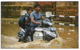
The IMD collates rainfall between June and September as SW monsoon. Answer the following question.
Study the picture on the right. Briefly explain what could be the cause of this calamity and what could be done to bring relief.
| On my visit to the queen of the hills, the city of Nainital in the month of December, there was snowfall and I stayed indoors. I was thrilled but also amazed as to why it occurred when it was cold winters. |
- What is the cause for the precipitation to occur at Nainital?
- Explain the phenomenon which leads to the given situation.
| At Lucknow, during the month of May, the hot dry season is characterized by a local wind, which increases the temperature for the city and keeps all the people mostly indoors during the afternoon. |
- What type of local wind is discussed?
- How is it responsible for the given climatic condition prevailing in the above-mentioned city?
Map Work
On the outline map of India:
- Colour the areas which receive less than 30 cm rainfall in a year.
- Write L over the region which is the last to receive the South-West Monsoon.
- Show by arrows, the direction of the rain bearing winds during winter and summer.
- Mark the wind direction in Ganga basin and Tamil Nadu coast in the month of January.
- Shade an area which receives rain in January and February.
- Shade and name the regions of India which experience cyclonic rain and convectional rain.
- Mark dots on the areas which are affected by Loo.
- Write HAR in an area having high annual range of temperature and LAR in an area having low annual range of temperature.
- Shade in different colours or patterns the three sources of rain in Punjab.
- Mark and name the mountain range and the direction of rain-bearing winds as a result both of which Rajasthan gets scanty rainfall.
Solutions for 7: Climate
Morning Star solutions for टोटल जियोग्राफी [अंग्रेजी] कक्षा १० आईसीएसई chapter 7 - Climate
Shaalaa.com has the CISCE Mathematics टोटल जियोग्राफी [अंग्रेजी] कक्षा १० आईसीएसई CISCE solutions in a manner that help students grasp basic concepts better and faster. The detailed, step-by-step solutions will help you understand the concepts better and clarify any confusion. Morning Star solutions for Mathematics टोटल जियोग्राफी [अंग्रेजी] कक्षा १० आईसीएसई CISCE 7 (Climate) include all questions with answers and detailed explanations. This will clear students' doubts about questions and improve their application skills while preparing for board exams.
Further, we at Shaalaa.com provide such solutions so students can prepare for written exams. Morning Star textbook solutions can be a core help for self-study and provide excellent self-help guidance for students.
Concepts covered in टोटल जियोग्राफी [अंग्रेजी] कक्षा १० आईसीएसई chapter 7 Climate are Distribution of Temperature, Land and Sea Breeze VS Monsoon Winds, Seasons in India > Hot Dry Summer, Seasons in India > The South-West Monsoon Season, Seasons in India > Retreating Monsoon, Seasons in India > The North-East Monsoon Season, Distribution of Rainfall, From Climate to Climate Change, Advance of the Southwest Monsoon, Characteristics of Southwest Monsoon, Differences between the Arabian Sea Branch · and the Bay of Bengal Branch of Southwest Monsoon Winds, Characteristics of Retreating Southwest monsoon season, Differences between the Advancing Southwest monsoon and the Retreating Southwest Monsoon, Differences between the rainfall brought by temperate cyclones and the rainfall brought by tropical cyclones, Cold Dry Winter Season, Characteristics of Cold dry winter season, South-West Monsoon VS Retreating Monsoon VS North-East Monsoon, Climate of India, Factors Affecting India's Climate, Distribution of Temperature, Land and Sea Breeze VS Monsoon Winds, Seasons in India > Hot Dry Summer, Seasons in India > The South-West Monsoon Season, Seasons in India > Retreating Monsoon, Seasons in India > The North-East Monsoon Season, Distribution of Rainfall, From Climate to Climate Change, Advance of the Southwest Monsoon, Characteristics of Southwest Monsoon, Differences between the Arabian Sea Branch · and the Bay of Bengal Branch of Southwest Monsoon Winds, Characteristics of Retreating Southwest monsoon season, Differences between the Advancing Southwest monsoon and the Retreating Southwest Monsoon, Differences between the rainfall brought by temperate cyclones and the rainfall brought by tropical cyclones, Cold Dry Winter Season, Characteristics of Cold dry winter season, South-West Monsoon VS Retreating Monsoon VS North-East Monsoon, Climate of India, Factors Affecting India's Climate.
Using Morning Star टोटल जियोग्राफी [अंग्रेजी] कक्षा १० आईसीएसई solutions Climate exercise by students is an easy way to prepare for the exams, as they involve solutions arranged chapter-wise and also page-wise. The questions involved in Morning Star Solutions are essential questions that can be asked in the final exam. Maximum CISCE टोटल जियोग्राफी [अंग्रेजी] कक्षा १० आईसीएसई students prefer Morning Star Textbook Solutions to score more in exams.
Get the free view of Chapter 7, Climate टोटल जियोग्राफी [अंग्रेजी] कक्षा १० आईसीएसई additional questions for Mathematics टोटल जियोग्राफी [अंग्रेजी] कक्षा १० आईसीएसई CISCE, and you can use Shaalaa.com to keep it handy for your exam preparation.
