Advertisements
Chapters
1: Interpretation of Topographical Maps
2: Contours
▶ 3: Scales and Direction
4: Map Reading and Interpretation
5: Map of India
PART II - GEOGRAPHY OF INDIA
6: Location, Extent and Physical Features
7: Climate
8: Soil Resources
9: Natural Vegetation
10: Water Resources
11: Mineral Resources
12: Conventional Sources of Energy
13: Non-Conventional Sources of Energy
14: Agriculture - I
15: Agriculture - II: Food Crops
16: Agriculture - III: Cash Crops (1)
17: Agriculture - IV: Cash Crops (2)
18: Manufacturing Industries (Agro-Based)
19: Mineral Based Industry
20: Transport
Chapter 21: Waste Management - I: Impact of Waste Accumulation
Chapter 22: Waste Management - II: Safe Disposal of Waste
![Morning Star solutions for टोटल जियोग्राफी [अंग्रेजी] कक्षा १० आईसीएसई chapter 3 - Scales and Direction - Shaalaa.com](/images/total-geography-english-class-10-icse_6:9033996325ef4d37a61a084b4444e2b2.jpg "Morning Star solutions for टोटल जियोग्राफी [अंग्रेजी] कक्षा १० आईसीएसई chapter 3 - Scales and Direction")
Advertisements
Solutions for Chapter 3: Scales and Direction
Below listed, you can find solutions for Chapter 3 of CISCE Morning Star for टोटल जियोग्राफी [अंग्रेजी] कक्षा १० आईसीएसई.
Morning Star solutions for टोटल जियोग्राफी [अंग्रेजी] कक्षा १० आईसीएसई 3 Scales and Direction EXERCISES [Pages 27 - 28]
Short Answer Questions
How is direction shown on a map?
What do you mean understand by Representative Fraction?
What is the advantage of R.F.?
Explain Magnetic declination with the help of a diagram.
Why are ‘True North’ and ‘Grid North’ different?
Answer the following questions:
What is a scale?
With regard to scale, answer the following question:
Name the main methods of representing the scale of a map.
With regard to scale, answer the following question:
Convert the following statement into R.F.
25 cm on the map = 5 km on ground.
With regard to scale, answer the following question:
Convert the following statement into R.F.
2½ inches on the map = 5 miles on ground.
With regard to scale, answer the following question:
Convert the following statement into R.F.
7 cm on the map = 63000 meters on ground.
With regard to scale, answer the following question:
Convert the following statement into R.F.
5 cm = 500 metres.
With regard to scale, answer the following question:
Convert the following statement into R.F.
15 cm = 6 km
Convert the following representative fraction into a statement:
1 : 63360 (to show miles).
Convert the following representative fraction into a statement:
1 : 1000000 (to show kilometres).
Convert the following representative fraction into a statement:
1 : 100 (to show metres).
Convert the following representative fraction into a statement:
1 : 10 (to show metres)
Convert the following representative fraction into a statement:
1 : 200,000 (to show kilometres)
Draw a linear scale and mark the following distance on that scale.
1 cm = 1 km (9 km).
Draw a linear scale and mark the following distance on that scale.
1 cm = 100 km (1100 km).
Draw a linear scale and mark the following distance on that scale.
1 : 500000 (13 km).
Draw a linear scale and mark the following distance on that scale.
1 : 20000 (250 metres).
The distance between New Delhi Station and Safdarjung Enclave bus stop is 20 km. On the map of Delhi it has been shown by a line of 3.5 cm. Draw the linear scale of the map and calculate the R.F.
On the map of India the cartographer forgot to draw the scale of the map. The student who knows the distance between Meerut and Delhi (70 km), was asked to complete the scale. How will the student draw the scale if he measures the distance between Delhi and Meerut on the map to be 5 cm? Give the procedure, draw the scale and find out the R.F.
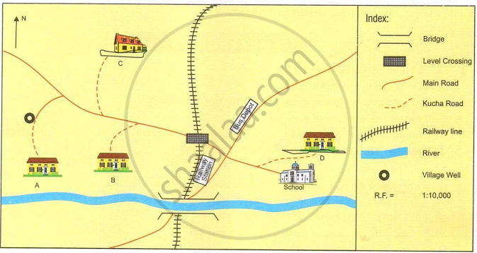
The map given below depicts the houses of four friends A, B, C and D. Find the distances using the main road and the kutcha road to answer the following questions.
- Which child would reach school first if all, A, B, and C, leave their houses at the same time and walk at the same speed?
- Which child lives closest to the school, according to the road distance?
- How far must D walk to reach the village well?
- How far is B’s house from the bus depot?
- How much distance will C have to walk to reach the railway station?
- In what direction is C’s house from the school?
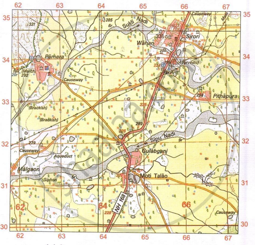
Study the given map extract and answer the following questions:
- Find the area in sq. km. of the area enclosed within the Eastings 64 to 64 and Northings 32 to 35.
- Find the compass direction of the following:
- Gulabganj from Pithapura
- Pamera from Malgaon
- Find the direct distance of the metalled road from the Post Office at Pamera till it intersects with National Highway NH 168 in grid square 6432.
Solutions for 3: Scales and Direction
Morning Star solutions for टोटल जियोग्राफी [अंग्रेजी] कक्षा १० आईसीएसई chapter 3 - Scales and Direction
Shaalaa.com has the CISCE Mathematics टोटल जियोग्राफी [अंग्रेजी] कक्षा १० आईसीएसई CISCE solutions in a manner that help students grasp basic concepts better and faster. The detailed, step-by-step solutions will help you understand the concepts better and clarify any confusion. Morning Star solutions for Mathematics टोटल जियोग्राफी [अंग्रेजी] कक्षा १० आईसीएसई CISCE 3 (Scales and Direction) include all questions with answers and detailed explanations. This will clear students' doubts about questions and improve their application skills while preparing for board exams.
Further, we at Shaalaa.com provide such solutions so students can prepare for written exams. Morning Star textbook solutions can be a core help for self-study and provide excellent self-help guidance for students.
Concepts covered in टोटल जियोग्राफी [अंग्रेजी] कक्षा १० आईसीएसई chapter 3 Scales and Direction are Map Scale, Types of Scale, Measuring Distance on the Map Using Scales, Elements of a Map, Types of Maps, Various Levels of Topographical Maps Based on Different Scales, Map Scale, Grid Reference, Methods of Representation of Relief on the Map > Hill Shading, Methods of Representation of Relief on the Map > Contours, Relationship Between Physical Features and Human Activities, Analysis of Topo-sheet No. G43S7, Analysis of Topo-sheet No. G43S10, Occupation, Settlement Pattern, Natural Vegetation, Human-Made and Natural Features, Topographic or Ordnance Survey Maps, National Grid Reference, Conventional Signs and Symbols used in Topographical Maps, River Features and Drainage Pattern in a Topographical Map, Representation of Relief Features, Methods of Representation of Relief on the Map > Hachures, Identification of Landforms Marked by Contours, Measurement of Distances on a Map, Means of Irrigation and Other Water Features in a Topographical Map, Direction, Representation of Heights in · Topographical Map, Map Reading, Primary Information or Marginal Information, Contour Diagrams, The Stages of the River, Structure of Topographical Map, Introduction to Topographical Maps and Their Significance, Elements of a Map, Types of Maps, Various Levels of Topographical Maps Based on Different Scales, Map Scale, Grid Reference, Methods of Representation of Relief on the Map > Hill Shading, Methods of Representation of Relief on the Map > Contours, Relationship Between Physical Features and Human Activities, Analysis of Topo-sheet No. G43S7, Analysis of Topo-sheet No. G43S10, Occupation, Settlement Pattern, Natural Vegetation, Human-Made and Natural Features, Topographic or Ordnance Survey Maps, National Grid Reference, Conventional Signs and Symbols used in Topographical Maps, River Features and Drainage Pattern in a Topographical Map, Representation of Relief Features, Methods of Representation of Relief on the Map > Hachures, Identification of Landforms Marked by Contours, Measurement of Distances on a Map, Means of Irrigation and Other Water Features in a Topographical Map, Direction, Representation of Heights in · Topographical Map, Map Reading, Primary Information or Marginal Information, Contour Diagrams, The Stages of the River, Structure of Topographical Map, Introduction to Topographical Maps and Their Significance.
Using Morning Star टोटल जियोग्राफी [अंग्रेजी] कक्षा १० आईसीएसई solutions Scales and Direction exercise by students is an easy way to prepare for the exams, as they involve solutions arranged chapter-wise and also page-wise. The questions involved in Morning Star Solutions are essential questions that can be asked in the final exam. Maximum CISCE टोटल जियोग्राफी [अंग्रेजी] कक्षा १० आईसीएसई students prefer Morning Star Textbook Solutions to score more in exams.
Get the free view of Chapter 3, Scales and Direction टोटल जियोग्राफी [अंग्रेजी] कक्षा १० आईसीएसई additional questions for Mathematics टोटल जियोग्राफी [अंग्रेजी] कक्षा १० आईसीएसई CISCE, and you can use Shaalaa.com to keep it handy for your exam preparation.
