Advertisements
Chapters
▶ 1: Interpretation of Topographical Maps
2: Contours
3: Scales and Direction
4: Map Reading and Interpretation
5: Map of India
PART II - GEOGRAPHY OF INDIA
6: Location, Extent and Physical Features
7: Climate
8: Soil Resources
9: Natural Vegetation
10: Water Resources
11: Mineral Resources
12: Conventional Sources of Energy
13: Non-Conventional Sources of Energy
14: Agriculture - I
15: Agriculture - II: Food Crops
16: Agriculture - III: Cash Crops (1)
17: Agriculture - IV: Cash Crops (2)
18: Manufacturing Industries (Agro-Based)
19: Mineral Based Industry
20: Transport
21: Waste Management - I: Impact of Waste Accumulation
22: Waste Management - II: Safe Disposal of Waste
![Morning Star solutions for टोटल जियोग्राफी [अंग्रेजी] कक्षा १० आईसीएसई chapter 1 - Interpretation of Topographical Maps - Shaalaa.com](/images/total-geography-english-class-10-icse_6:50f152b897f542b0866f1c409a32fe3b.jpg "Morning Star solutions for टोटल जियोग्राफी [अंग्रेजी] कक्षा १० आईसीएसई chapter 1 - Interpretation of Topographical Maps")
Advertisements
Solutions for Chapter 1: Interpretation of Topographical Maps
Below listed, you can find solutions for Chapter 1 of CISCE Morning Star for टोटल जियोग्राफी [अंग्रेजी] कक्षा १० आईसीएसई.
Morning Star solutions for टोटल जियोग्राफी [अंग्रेजी] कक्षा १० आईसीएसई 1 Interpretation of Topographical Maps EXERCISES [Page 11]
Short Answer Questions
What is a map?
State the essential features of a map.
What do you mean by the ‘key’ of a map?
Name the categories into which maps have been classified.
Write a short note on Topographical Maps.
What is the National Grid Reference (NGR)?
Structured Questions
Give the four-figure grid reference of the following from the given map extract:
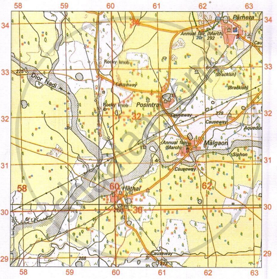
- Two settlements having a Post office.
- Two settlements having a dispensary.
- The Siphon.
- The confluence of the main river and Dior Nadi.
- The area of Brackish water.
- The Annual Fair grounds west of Malgaon.
Give the six-figure grid reference of the following from the given map extract:
- Police Station.
- 4r near the Rocky knob.
- Post office at Malgaon.
- The surveyed tree at Posintra.
- Dispensary north of Posintra.
- Hospital near Pamera.
Project/Activity
Identify the survey sheet of your city. Make a list of the important features both man-made and natural.
Solutions for 1: Interpretation of Topographical Maps
Morning Star solutions for टोटल जियोग्राफी [अंग्रेजी] कक्षा १० आईसीएसई chapter 1 - Interpretation of Topographical Maps
Shaalaa.com has the CISCE Mathematics टोटल जियोग्राफी [अंग्रेजी] कक्षा १० आईसीएसई CISCE solutions in a manner that help students grasp basic concepts better and faster. The detailed, step-by-step solutions will help you understand the concepts better and clarify any confusion. Morning Star solutions for Mathematics टोटल जियोग्राफी [अंग्रेजी] कक्षा १० आईसीएसई CISCE 1 (Interpretation of Topographical Maps) include all questions with answers and detailed explanations. This will clear students' doubts about questions and improve their application skills while preparing for board exams.
Further, we at Shaalaa.com provide such solutions so students can prepare for written exams. Morning Star textbook solutions can be a core help for self-study and provide excellent self-help guidance for students.
Concepts covered in टोटल जियोग्राफी [अंग्रेजी] कक्षा १० आईसीएसई chapter 1 Interpretation of Topographical Maps are Elements of a Map, Types of Maps, Various Levels of Topographical Maps Based on Different Scales, Map Scale, Grid Reference, Methods of Representation of Relief on the Map > Hill Shading, Methods of Representation of Relief on the Map > Contours, Relationship Between Physical Features and Human Activities, Analysis of Topo-sheet No. G43S7, Analysis of Topo-sheet No. G43S10, Occupation, Settlement Pattern, Natural Vegetation, Human-Made and Natural Features, Topographic or Ordnance Survey Maps, National Grid Reference, Conventional Signs and Symbols used in Topographical Maps, River Features and Drainage Pattern in a Topographical Map, Representation of Relief Features, Methods of Representation of Relief on the Map > Hachures, Identification of Landforms Marked by Contours, Measurement of Distances on a Map, Means of Irrigation and Other Water Features in a Topographical Map, Direction, Representation of Heights in · Topographical Map, Map Reading, Primary Information or Marginal Information, Contour Diagrams, The Stages of the River, Structure of Topographical Map, Introduction to Topographical Maps and Their Significance.
Using Morning Star टोटल जियोग्राफी [अंग्रेजी] कक्षा १० आईसीएसई solutions Interpretation of Topographical Maps exercise by students is an easy way to prepare for the exams, as they involve solutions arranged chapter-wise and also page-wise. The questions involved in Morning Star Solutions are essential questions that can be asked in the final exam. Maximum CISCE टोटल जियोग्राफी [अंग्रेजी] कक्षा १० आईसीएसई students prefer Morning Star Textbook Solutions to score more in exams.
Get the free view of Chapter 1, Interpretation of Topographical Maps टोटल जियोग्राफी [अंग्रेजी] कक्षा १० आईसीएसई additional questions for Mathematics टोटल जियोग्राफी [अंग्रेजी] कक्षा १० आईसीएसई CISCE, and you can use Shaalaa.com to keep it handy for your exam preparation.
