Hanumanji ka Mandir is located to the north-east of Gautam Maharishi Mandir.
Advertisements
Advertisements
प्रश्न
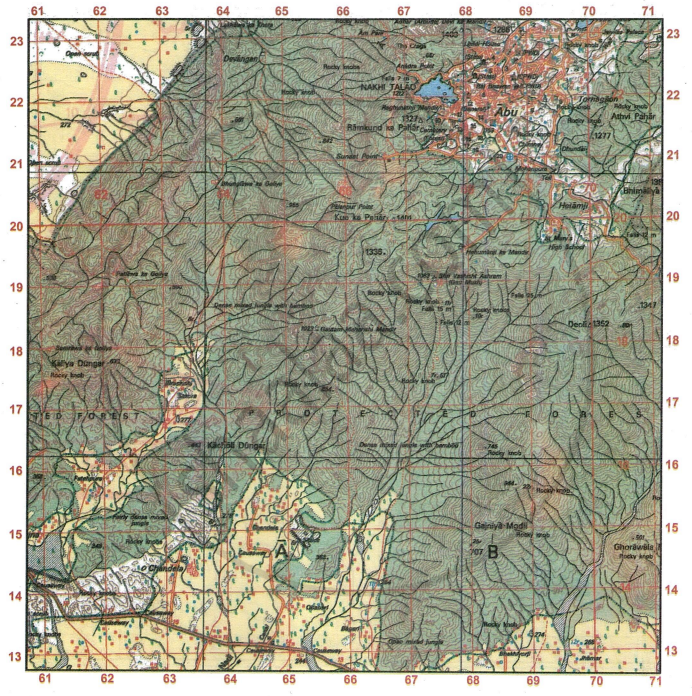
Study the extract of the Survey of India Map Sheet No. G43S10 and answer the following questions [Eastings 61-71, Northings 13-23]:
-
- Give the four-figure grid reference of the perennial well to the north of Jhamar.
- Give the six-figure grid reference of the temple at Shri Vashisht Ashram.
-
- What is the area in kilometres of the forested region enclosed within Eastings 66 and 71 and Northings 15 and 19?
- What is the compass direction of Hanumanji ka Mandir from Gautam Maharishi Mandir?
-
- What does the word ‘Falls 15m’ in grid square 6718 indicate? Explain how these falls are formed.
- What is the distance, in kilometres along the metalled road from distance stone 16 (grid square 6313) to the canal in grid square 6413?
-
- Abu is a big settlement with high water demand. From where does it get its main water supply? Give two reasons to support your answer.
- What is indicated by the large number and the closeness of the contour lines in the given map extract?
-
- What do the broken black lines in grid square 6221 indicate? How are they formed?
- Why are there no settlements except Abu in the given map extract? Give a reason to support your answer.
स्पष्ट कीजिए
कारण बताइए
विस्तार में उत्तर
Advertisements
उत्तर
-
- 6913
- 674190
-
- The number of grid squares enclosed between Eastings 66 and 71 and Northings 15 and 19 is 20. As each grid square represents an area of 1 km × 1 km, or 1 sq. km, the total area covered by these 20 grid squares is 20 sq. km.
-
-
-
‘Falls 15m’ in grid square 6718 shows a waterfall with a height of 15 metres. Such falls are formed in hilly regions where a river makes a sudden and nearly vertical drop along its course.
- The distance measured on the map is 3.2 cm. As the scale is 2 cm = 1 km, the real distance comes out to be 1.6 km.
-
-
- Abu is a hilly region that receives its water from seasonal streams, wells, and artificial lakes. This is because:
(A) There are no perennial rivers; only seasonal streams are found in the area. (B) Perennial lined wells and Nakhi Talao are present, as shown by the blue conventional symbols on the map. - The large number of closely spaced contours shows that the land has a steep slope.
- Abu is a hilly region that receives its water from seasonal streams, wells, and artificial lakes. This is because:
-
- The broken black lines in grid square 6221 represent broken ground. Such features are commonly found in arid or semi-arid areas, especially along the banks of seasonal rivers or streams. This occurs because the soil is soft and sandy, and it cracks and breaks easily due to alternating wet and dry periods.
- Except for Abu, there are no other settlements shown in the given map extract, as most of the region is covered with forests and rocky knobs, and there is a lack of perennial streams, transport facilities, and employment opportunities.
shaalaa.com
क्या इस प्रश्न या उत्तर में कोई त्रुटि है?
