Advertisements
Advertisements
प्रश्न
Study the extract of the Survey of India Map Sheet No. G43S10 and answer the following questions [Eastings 47-57, Northings 13-23]:
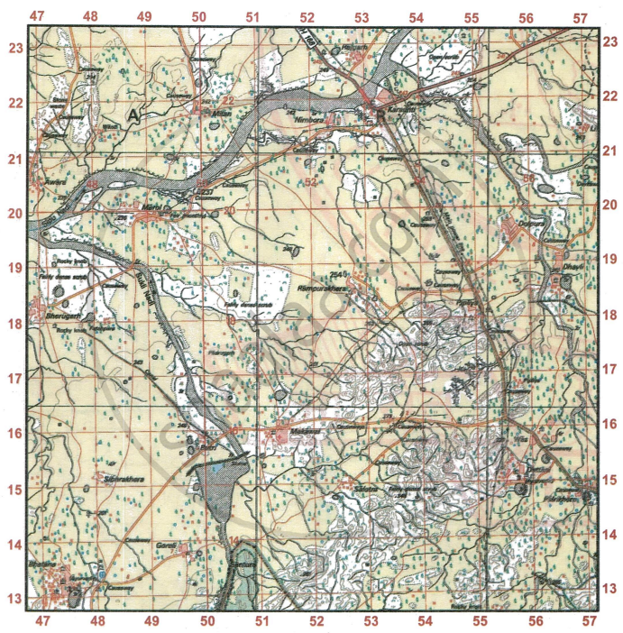
- Give the four-figure grid reference of
- the centre of the dry tank located to the north of Makawal.
- the highest point on the given map extract.
- the settlement of Karaunti.
- Name and give the six-figure grid reference of:
- the medical facility at Makawal.
- 5r at the confluence of Sipu Nadi and Sukli Nadi.
- the temple at Marol.
- the perennial lined well at the settlement of Goreli.
- State the compass direction of
- Was from Dolpura.
- Sibhrakhera from Rampurakhera.
- Rampurakhera from Sibhrakhera.
- Find the distance in km along the cart-track going south-west from Mitan (the point where three cart-tracks meet in grid square 5021) where it meets be the metalled road in grid square 5218.
- On which bank of Sukli Nadi lies:
- Butri
- Padrugarh
- Name the two settlements which have an Ayurvedic dispensary.
- State the reason for a number of causeways in the given map extract.
- Suppose you walk along the metalled road at a speed of 1 kilometer per hour from grid square 5517 to the distance stone numbered 29, how much time will you take to reach your destination? Write your answer in hours and minutes.
- Find the length, in kilometres of the canal between the sluice 7r and rocky knob in grid square 4717.
- Measure the direct distance in kilometers, from the chhatri in the grid square 4915 to the temple in the grid square 4717.
- What is the area in square km of the region enclosed within Eastings 52 to 55 and Northings 14 and 17.
- Give a reason for each of the following:
- Broken ground along the banks of Sipu river.
- Fairly dense scrub vegetation in the south-east part of the given map extract.
- State the occupations followed by the people at Dattani. Give reasons to support your answer.
- Explain the following terms:
- Stony Waste
- Causeway
- What difference do you notice in the drainage patterns between the streams in grid square 5315 and the streams in grid square 5119?
- Describe the drainage pattern in grid square 5117.
- What does 7r indicate in the grid square 5015 and 3r shown in the grid square 5514?
- What is an ‘Open jungle’? What does it show about the rainfall in the region on the given map extract?
- Explain one relief feature indicated by contour lines in grid square 5417.
- What are the probable occupations followed by the people living in the area shown in the given map extract?
- From where does the settlement of Dhavli get its water. Give a reason to support your answer.
- Name the prominent settlement in this extract. Give reasons to support your answer.
स्पष्ट कीजिए
कारण बताइए
विस्तार में उत्तर
Advertisements
उत्तर
-
- 5116
- 5417
- 5321
-
- 514158
- 471196
- 492199
- 491137
-
- South
- South West
- North east
- 3 km 950 m
-
- Butri - Left Bank
- Padrugarh - Right Bank
- Bhatna, Dattani
- The region receives seasonal rainfall. In order to cross the minor streams during rainy seasons, the raised metalled road (causeway) is made.
- 4 hours
- 3 km 600 m
- 3 km 150 m
- No. of Easting = 3
No. of Northing = 3
Area = 3 × 3 = 9 sq km. -
- The river’s banks are soft/sandy and subject to repeated wetting, drying and scouring by seasonal flows, so the soil cracks and breaks producing broken ground.
- The area is rocky/undulating with shallow poor soils and limited perennial water, so land is unsuitable for cultivation and supports scrub vegetation.
- Cattle rearing due to the presence of white colour patch and fairly dense scrub.
-
- Stony Waste: It is an area of semi arid land where sand, stones are found.
- Causeway: It is the raised metalled road to cross the minor streams.
- 5315 - Radial
- 5119 - Disappearing
- 5117 - Dendritic
-
- 7r (5015) - The relative height of ambankment is 7 m.
- 3r (5514) - Relative height of dry tank with embankment is 3 m.
- Open jungle indicates that the area receives moderate rainfall. The trees are not too close to one another.
- Ridge
- Farming
- Perennial lined well. Presence of blue colour dots.
- Bhatana, due to presence of post office, ayurvedic dispensary, temples, perennial lined wells, cart tracks.
shaalaa.com
क्या इस प्रश्न या उत्तर में कोई त्रुटि है?
