Advertisements
Online Mock Tests
Chapters
![Balbharati solutions for Geography [English] Standard 10 Maharashtra State Board chapter 3 - Physiography and Drainage - Shaalaa.com](/images/geography-english-standard-10-maharashtra-state-board_6:64aff6684df04e9e943283f0e8e55f89.jpg "Balbharati solutions for Geography [English] Standard 10 Maharashtra State Board chapter 3 - Physiography and Drainage")
Advertisements
Solutions for Chapter 3: Physiography and Drainage
Below listed, you can find solutions for Chapter 3 of Maharashtra State Board Balbharati for Geography [English] Standard 10 Maharashtra State Board.
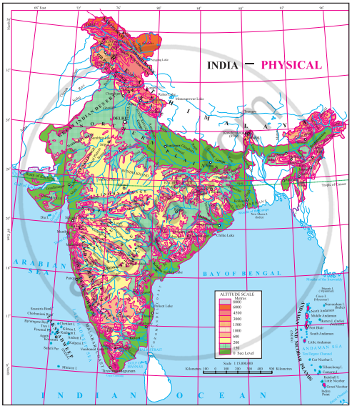
Balbharati solutions for Geography [English] Standard 10 Maharashtra State Board 3 Physiography and Drainage Intext Questions [Pages 14 - 23]
Observe the map and answer the following questions:
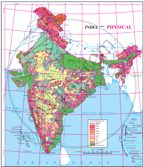
- In which direction does the region with an altitude of more than 6000 m lie in India?
- Look for the south-flowing river in the peninsular region. In which river basin does it lie?
- In which direction is the slope of the region in the north shown in dark green?
- Make a list of plateaus located in between the Aravali ranges and the Chhota Nagpur Plateau.
- Name the peak shown in the Eastern Ghats.
- Which mountains demarcate the deep plains of the Brahmaputra?
- Give the relative location of the Nilgiri Hills.
- In which direction does the height of the Sahyadri hills increase?
- The Vindhyas act as a water divide between which two river basins?
- In which direction do the Aravalis lie?
- Aravali ranges act as a water divide between which rivers?
- Name the hills located on the plateaus to the east of the Aravalis.
- Across which states have the Deccan Plateau spread?
- Which hill ranges lie to the west of the Deccan Plateau?
- Enumerate the characteristics of the Western Ghats.
- Compare the Eastern and the Western Ghats.
- Why are the Western Ghats called a water divide?
Make friends with maps!
Observe the figure and answer the following questions:
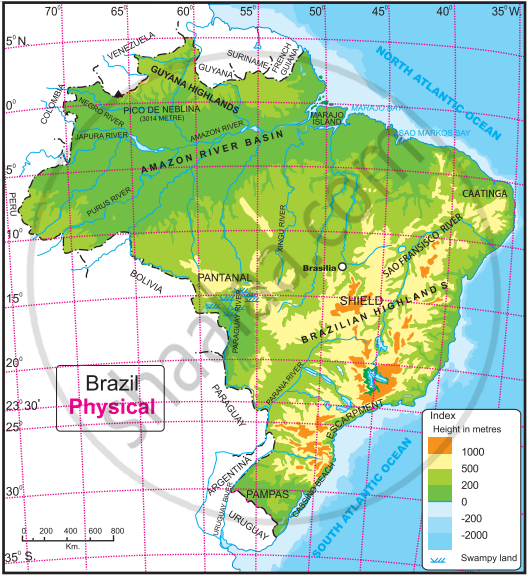
- What is the range of the altitude of Amazon river basin?
- Between which two highlands is the Amazon river basin located?
- Observe the region with the altitude 500 to 1000 metres. Describe the locational extent of this region shown in yellow with reference to direction.
- What do the isolated regions shown in yellow indicate?
- Besides the Amazon river basin, where else do you find regions with an altitude of less than 200 m?
- Describe the plateau region with height of 200 to 500 m through which tributaries of Amazon flow in your own words.
Figures show the physiography of India and Brazil. Use the maps and the indices to answer the following.
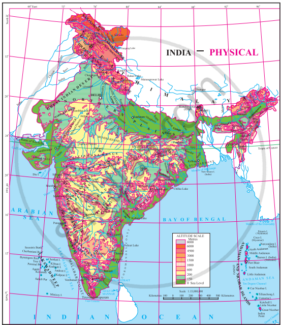
Compare the indices of both the maps.
- In which parts do the areas with highest altitude lie in both the countries, respectively?
- In which country is the range of altitude higher?
- Compare the highest range of altitudes given in both the countries. What difference do you see?
- In which direction is the slope of the Amazon river basin region?
- In which direction is the slope of the Deccan Plateau of India?
- Tell the regions of rain shadow in both the countries.
- Considering the distribution of altitude, direction of slope of land and other characteristics of physiography, write 10 sentences each about the physiography of India and Brazil.
Write a comparative note on the basins of Ganga and Amazon river. You may consider following points for the comparison.
- Size of catchment area (consider the map)
- Their relative location within respective countries.
- Headwater regions of rivers.
- Orientation of the rivers
- Major tributaries and their orientation.
- Any other point(s).
Some more information:
| Ganga River | Amazon River | |
| Total catchment area (in sq.km) | 10,16,124 | 70, 50, 000 |
| Total length of river (in kms) | 2,525 | 6,400 |
| Water discharge (Cu.m. per sec) | 16, 648 | 2,09,000 |
Many geologists say that the rivers of the Himalayas are older than the Himalayas themself. Try to find out the reason behind this.
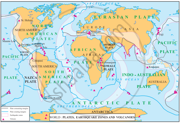
Look at the map. Compare it with the physical map of Brazil. Think about the potential areas where earthquakes may occur.
Balbharati solutions for Geography [English] Standard 10 Maharashtra State Board 3 Physiography and Drainage Exercise [Pages 23 - 24]
Complete the sentences by choosing the right option:
Brazil is covered mainly by ______.
Highlands
Plains
Mountainous region
Dissected hills
Like Brazil, India too has ______.
High mountains
Ancient plateau
West-flowing rivers
Snow-capped mountains
The Amazon Basin is mainly ______.
characterized by droughts
filled by swamps
covered by dense forests
fertile
Amazon is a large river in the world. Near its mouth ______.
deltaic regions are found
no deltas are found
deposition of sediments occurs
fishing is done
The Lakshadweep Islands of Arabian Sea are ______.
made from the part separated from the mainland
coral islands
volcanic islands
continental islands
To the foothills of the Aravalis ______.
lies the Bundelkhand Plateau
lies the Mewad Plateau
lies the Malwa Plateau
lies the Deccan Plateau
Answer the following questions.
Differentiate between the physiography of Brazil and India.
What measures are being taken to control pollution in the rivers of India?
Explain the characteristics of the North Indian Plains.
What could be the reasons behind the formation of swamps in the extensive continental location of Pantanal?
Which are the major water divides of India giving examples.
Write a note on the Amazon River basin.
Write a note on the Himalayas.
Write a note on the coasts of Brazil.
Write a note on the Indian Peninsula.
Write a note on the Great Escarpment.
Write geographical reasons.
There are no west-flowing rivers in Brazil.
Write geographical reasons:
There are dissimilarities between the eastern and western coasts of India.
Write geographical reasons.
There are fewer natural ports on the eastern coast of India.
Write geographical reasons.
As compared to Amazon, pollution in river Ganga will affect human life greatly.
Identify the correct group.
The order of physiographic units in Brazil while going from North-West to South-East.
Parana River basin - Guyana Highlands - Brazilan Highlands
Guyana Highlands - Amazon river basin - Brazilan Highlands
Coastal Plains - Amazon river basin - Brazilan Highlands
Identify the correct group.
These rivers of Brazil are north-flowing.
Juruika - Xingu - Aragua
Negro - Branco - Paru
Japura - Jarua - Purus
Identify the correct group.
The order of plateaus of India from south to north.
Karnataka - Maharashtra - Bundelkhand
Chhota Nagpur - Malwa - Marwad
Telangana - Maharashtra - Marwad
Activity:
Observe figures and fill in the following table with the physiographic divisions found in the States of India and Brazil respectively.
| States of India | Physical Divisions |
States of Brazil | Physiographic Divisions |
Solutions for 3: Physiography and Drainage
Balbharati solutions for Geography [English] Standard 10 Maharashtra State Board chapter 3 - Physiography and Drainage
Shaalaa.com has the Maharashtra State Board Mathematics Geography [English] Standard 10 Maharashtra State Board Maharashtra State Board solutions in a manner that help students grasp basic concepts better and faster. The detailed, step-by-step solutions will help you understand the concepts better and clarify any confusion. Balbharati solutions for Mathematics Geography [English] Standard 10 Maharashtra State Board Maharashtra State Board 3 (Physiography and Drainage) include all questions with answers and detailed explanations. This will clear students' doubts about questions and improve their application skills while preparing for board exams.
Further, we at Shaalaa.com provide such solutions so students can prepare for written exams. Balbharati textbook solutions can be a core help for self-study and provide excellent self-help guidance for students.
Concepts covered in Geography [English] Standard 10 Maharashtra State Board chapter 3 Physiography and Drainage are Physical Division of India > The Coastal Plains, Physical Division of Brazil> Islands, Physical Division of India > The Peninsula, Drainage of Brazil, Drainage of India, Physical Division of Brazil> The Highlands, Physical Division of India> The Himalayas, Physical Division of India > The Island Group, Physical Division of Brazil> The Great Escarpment, Physical Division of Brazil> The Coasts, Map Study: Physical Divisions of India, Map Study: Physical Divisions of Brazil, Physical Division of India > North Indian Plains, Physical Division of Brazil> The Plains, Comparative Study of the Ganga and Amazon River Basins.
Using Balbharati Geography [English] Standard 10 Maharashtra State Board solutions Physiography and Drainage exercise by students is an easy way to prepare for the exams, as they involve solutions arranged chapter-wise and also page-wise. The questions involved in Balbharati Solutions are essential questions that can be asked in the final exam. Maximum Maharashtra State Board Geography [English] Standard 10 Maharashtra State Board students prefer Balbharati Textbook Solutions to score more in exams.
Get the free view of Chapter 3, Physiography and Drainage Geography [English] Standard 10 Maharashtra State Board additional questions for Mathematics Geography [English] Standard 10 Maharashtra State Board Maharashtra State Board, and you can use Shaalaa.com to keep it handy for your exam preparation.
