Advertisements
Advertisements
Question
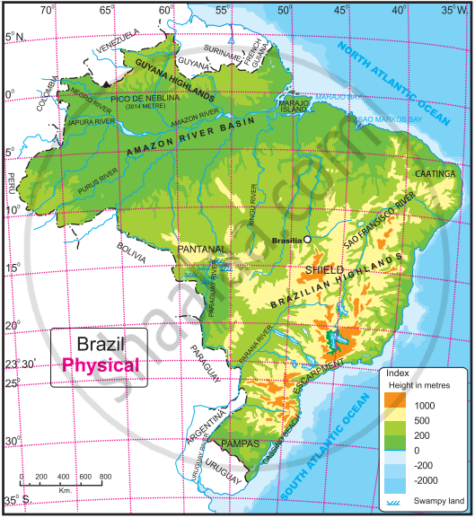
Observe figures and fill in the following table with the physiographic divisions found in the States of India and Brazil respectively.
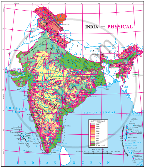
| States of India | Physical Divisions |
States of Brazil | Physiographic Divisions |
Activity
Advertisements
Solution
| States of India | Physical Divisions |
States of Brazil | Physiographic Divisions |
| Jammu and Kashmir/Ladakh (Union territories) | Himalayan mountain ranges | Amazonas | Guyana Highland lies in the north and Pico de Neblina (3014 m) is the highest peak |
| Rajasthan | West - Desert region East - Plain Central and South - Plateau region (Marwar and Mewad) and Aravali mountain |
Para | Mainly Amazon River Basin and Amazon plains. Moraza island near the mouth of Amazon river and Moraza bay on the east of island. |
| Uttar Pradesh | Flat plain region (Ganga River basin) | Mato Grosso | Plain region towards north, west and east region consist of Brazil’s Plateau and towards south is Pantanal region near Paraguay basin. |
| Gujarat | West - Rann of Kutch, Gulf of Kutch near the coastal region, Gulf of Khambhat near south region. Mouth of rivers Mahi and Tapi. |
Sao Paulo | Mainly the plateau region, the Great Escarpment region towards the east. |
| Madhya Pradesh | Mainly Plateau region (Marwar, Bundelkhand, Baghelkhand Plateaus) South Vindhya ·and Satpura ranges, Mahadeo and Maikal Ranges Northwest - Charnbal river North - Betwa nver and Ken river. | Minas Gerais | Mainly Brazilian Highlands region |
| Orissa | Malayagiri and Mahendragiri ranges in north and south of Eastern Ghats. Delta is formed near the mouth of River Mahanadi and Chilka which is a salt water lake is situated near the mouth of River Mahanadi. It forms a part of the eastern coastal re ion. | Rio de Janerio | Eastern coastal region and beaches |
shaalaa.com
Is there an error in this question or solution?
