(English Medium)
Academic Year: 2018-2019
Date: March 2019
Advertisements
(1) Attempt all Questions from Part 1
(2) Attempt only Five Question from part 2
Study the extract of the Survey of India Map sheet No. 45D/10 and answer the following questions:

-
- Give the six-figure grid reference for the temple that is located to the southwest of Pithapura settlement. (1)
- Give the four-figure grid reference for a settlement where people of the region meet socially and for trade at least once in year. (1)
-
- What is the pattern of drainage seen in the grid square 2118? (1)
- What is the pattern of settlement seen in the grid square 1923? (1)
- What do each of the two numbers (281 printed in black colour and 20 printed in red colour) in the grid square 1818 indicate? (2)
-
- Name any two man-made features in grid square 2419. (1)
- Name any two natural features in grid square 2118. (1)
- What is the significance of the following?
- Fire line in grid square 2417. (1)
- Water body found in grid square 2221. (1)
- Calculate the area of the region between 16 and 19 Eastings and 18 and 22 Northings. Give your answer in square kilometers. (2)
- Give a reason for each of the following:
- The water in some of the wells in the north-west quarter of the map is not fit for drinking. (1)
- The region near Anadra and Gulabgani has many causeways. (1)
-
- What is the main means of irrigation used by people living in the area shown on the map? (1)
- What is the main occupation of the people of the region shown on the map? (1)
- Which, according to you, is the most important settlement? Give a reason to support your answer. (2)
- Name any two means of transport used by the people living in the area shown on the map extract. (2)
Chapter: [1] Interpretation of Topographical Maps
On the outline map of India provided:
(a) Shade and label the Gangetic Plain. [1]
(b) Shade and label an area of laterite soil in North India. [1]
(c) Mark and label the Karakoram Mountains. [1]
(d) Mark and name the Palk Strait. [1]
(e) Shade and label the river Cauveri. [1]
(f) Mark and name Mumbai. [1]
(g) Mark and name the Nathu La Pass. [1]
(h) Mark and name Digboi. [1]
(i) Shade and name the Deccan Plateau. [1]
(j) Shade and label the river Jhelum. [1]
Chapter: [2] Map of India
What type of wind is ‘Monsoon’? What is its direction during summer?
Chapter:
Mention two characteristics of the Indian monsoon.
Chapter:
With reference to the summer season in India, answer the following question:
Mention the duration of the summer season in India.
Chapter:
What is the atmospheric pressure condition during summer season over the central part of India?
Chapter:
Give a reason :
Goa receives heavier rainfall than Puducherry.
Chapter:
Give the Reason:
Mawsynram receives the highest average annual rainfall.
Chapter:
Give the reason:
Mangaluru is cooler than Delhi in summer season.
Chapter:
Study the data of distribution of temperature and rain for Station X and answer the questions that follow:

- Is Station X in the coastal area or in the interior of the country?
- Calculate the total annual rainfall for Station X.
- Name the wind that brings most of the rainfall to Station X.
Chapter:
Name the Indian soil which is formed due to the weathering of basic igneous rocks.
Chapter:
name two states of India where this type of soil is found.
Chapter:
Name the following :
An important transported soil of India.
Chapter:
Name the following:
Soil that is rich in iron oxide.
Chapter:
Give a geographical reason for each of the following:
Terrace farming is an ideal soil conservation method for hilly regions.
Chapter:
Give a geographical reason for the following:
Dry farming is preferred in areas with red soil.
Chapter:
Give a geographical reason for each of the following:
Wind is a common agent of soil erosion in arid regions.
Chapter:
Briefly answer the following:
Mention one way in which man is responsible for soil erosion.
Chapter:
Briefly answer the following:
How.can deepening of the river bed help in preventing soil erosion?
Chapter:
Briefly answer the following:
Mention a physical characteristic of Laterite soil.
Chapter:
Give two reasons to explain as to why we need to conserve our forest resource.
Chapter: [5] Natural Vegetation
Mention two conditions required for the growth of Littoral Forest.
Chapter: [5] Natural Vegetation
State one characteristic feature of the forest found in the Nilgiri Hills
Chapter: [5] Natural Vegetation
Give two reasons to explain as to why the Tropical Evergreen Forests are difficult to exploit for commercial purpose.
Chapter: [5] Natural Vegetation
Name any two trees found in Tropical Evergreen forests .
Chapter: [5] Natural Vegetation
Advertisements
Briefly explain the following:
The trees in the Tropical Desert Forest have stunted growth.
Chapter: [5] Natural Vegetation
There is a gradual increase in the forest cover in India in recent times.
Chapter: [5] Natural Vegetation
The trees in Monsoon Deciduous forests, shed their leaves for about 6-8 weeks during March and April.
Chapter: [5] Natural Vegetation
“The modern means of irrigation are gaining popularity.” Give two reasons to justify this statement.
Chapter: [6] Water Resources
Mention two factors that favour the development of tube well irrigation in Punjab.
Chapter: [6] Water Resources
Most of the South Indian states are not suitable for development of canal irrigation.
Chapter: [6] Water Resources
There is an urgent need for water conservation in India.
Chapter: [6] Water Resources
Development of irrigation is essential for the growth of the agriculture sector of India.
Chapter: [6] Water Resources
Give two advantages of using bio-gas as a source of power .
Chapter:
A metallic mineral for which the Balaghat district of Madhya Pradesh is famous.
Chapter:
The multi-purpose project based on the River Sutlej .
Chapter:
Odisha has benefitted greatly from the Hirakud project.
Chapter:
India’s location is advantageous for the generation of solar power.
Chapter:
Name a mineral used to generate nuclear power.
Chapter:
Why is petroleum often referred to as “liquid gold”?
Chapter:
State one disadvantage of using coal as a source of power.
Chapter:
Mention two steps taken by the government to boost agricultural production in India.
Chapter:
What is the soil requirement for growing millet?
Chapter:
Study the picture given below and answer the questions that follow:
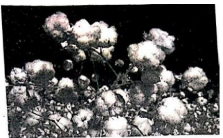
(i) Mention the climatic condition that is suitable for the cultivation of this crop.
(ii) Name the state that produces the largest amount of this crop.
(iii) In which cropping season is this crop grown in India?
Chapter:
Give a geographical reason for the following:
Cultivation of wheat is confined to the northern part of India.
Chapter:
Practicing mixed farming gives security to farmers.
Chapter:
Advertisements
Ratoon cropping is gaining popularity among sugarcane cultivators.
Chapter:
Where do the following iron and steel plants get their supply of iron ore from?
Bhilai Iron and Steel Plant.
Chapter:
Where do the following iron and steel plants get their supply of iron ore from?
Vishakhapatnam Steel Plant.
Chapter:
‘Karnataka has developed as an important state for the growth of the Silk industry.‘ Give two reasons to justify the statement.
Chapter:
Why should these industries be located close to the sugarcane growing areas?
Chapter:
Mention one leading sugar producing state in North India.
Chapter:
Mention one leading sugar producing state in South India.
Chapter:
Ahmedabad is an important cotton textile producing centre in India.
Chapter:
Cottage industries are significant for our economy
Chapter:
Petrochemical industries are usually located close to the oil refineries.
Chapter:
“Roadways are an important means of transport in India”. Give two reasons to justify the statement.
Chapter:
Why are South Indian rivers not ideal for the inland water transport?
Chapter:
Give a geographical reason for the following:
Nearly seventy percent of Indians do not use air transport.
Chapter:
A well-developed transport network is important for industrial growth.
Chapter:
Water transport is not as popular as land transport in India.
Chapter:
“The railway is an important means of transport as compared to, airways.” State two reasons to support the statement.
Chapter:
Quality of air around us.
Chapter: [11] Waste Management
Quality of water around us.
Chapter: [11] Waste Management
Mention two ways in which the decomposition of waste in open areas can affect human health.
Chapter: [11] Waste Management
What can an individual do to reduce waste at home?
Chapter:
Why musation of waste be done before disposal?
Chapter:
How has composting proven to be a great help in managing waste?
Chapter:
Trees must be planted in the industrial areas.
Chapter:
Chemical fertilizers must be replaced by organic manure
Chapter:
Other Solutions
Submit Question Paper
Help us maintain new question papers on Shaalaa.com, so we can continue to help studentsonly jpg, png and pdf files
CISCE previous year question papers ICSE Class 10 Geography with solutions 2018 - 2019
Previous year Question paper for CISCE ICSE Class 10 -2019 is solved by experts. Solved question papers gives you the chance to check yourself after your mock test.
By referring the question paper Solutions for Geography, you can scale your preparation level and work on your weak areas. It will also help the candidates in developing the time-management skills. Practice makes perfect, and there is no better way to practice than to attempt previous year question paper solutions of CISCE ICSE Class 10 .
How CISCE ICSE Class 10 Question Paper solutions Help Students ?
• Question paper solutions for Geography will helps students to prepare for exam.
• Question paper with answer will boost students confidence in exam time and also give you an idea About the important questions and topics to be prepared for the board exam.
• For finding solution of question papers no need to refer so multiple sources like textbook or guides.
