Advertisements
Advertisements
Question
Study the climate data of Station X and answer the questions that follow:
| Month | JAN | FEB | MAR | APR | MAY | JUNE | JULY | AUG | SEPT | OCT | NOV | DEC |
| Temp. °C | 8.4 | 11.5 | 21.6 | 28.3 | 35.1 | 38.5 | 41.0 | 38.0 | 30.8 | 29.2 | 15.6 | 10.2 |
| Rainfall in cms | 1.5 | 0.9 | 0.5 | - | - | 12.5 | 17.8 | 18.5 | 12.5 | 12.5 | 6.2 | 2.1 |
- Calculate the annual range of temperature of Station X.
- Name the rainiest month of the Station X.
- Is the Station X located in coastal area or in the continental interior?
Advertisements
Solution
- Annual range of the temperature = Maximum temperature - Minimum temperature
= 41.0 - 8.4
= 32.6° C - August has the highest rainfall, averaging 18.5 cm.
- Given the wide range of annual temperatures, which points to a continental climate, Station X most likely situated inland on the continent as opposed to at the seashore.
APPEARS IN
RELATED QUESTIONS
Give geographical reasons:
Convectional type of rainfall is not prominent in India.
Explain the importance of the Himalayas and the Indian Ocean with respect to the climate of India.
Compare the climates of Brazil and India.
Match the following
| 1. | Sundarbans | Desert and semi desert vegetation |
| 2. | Biodiversity hotspot | October - December |
| 3. | North east monsoon | Littoral forest |
| 4. | Tropical thorn forests | West Beangal |
| 5. | Coastal forests | The Himalayas |
Palmyra is found in ______ forests.
Match the Column I with Column II.
| Column I | Column II | |
| A. | Tropical evergreen forest | Sandal wood |
| B. | Tropical Deciduous forest | Oak, silver fir |
| C. | Alpine forest | Black buck |
| D. | Tidal forest | Casuarina |
| E. | Coastal forest | Mahogany |
| F. | State animal of Andhra Pradesh, Pujab and Haryana | Mangrove trees |
The Himalayas act not only as physical barrier but also as ______.
Mark the following on the outline map of India.
- Direction of South West Monsoon wind.
- Direction of North East Monsoon wind.
- Areas of heavy rainfall.
- Mountain forests.
- Panna biosphere reserve
- Agasthiyamalai biosphere reserve
Observe the following graph and answer the questions given below:
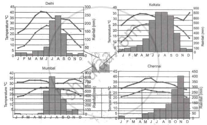
Note: In the graphs, the dark line represents the max. temperature and the lighter line represents min. temperature. The bars represent the amount of rainfall every month in each city.
- Where in the four cities is the rainfall heaviest?
- Which city has the most rainfall throughout the year?
- Which city experiences the highest temperature?
- Calculate the average range of minimum and maximum temperature for all four cities.
- What do the temperature curves in Delhi indicate?
- What is the condition of Mumbai during monsoons?
Choose the odd man out:
Region with very high rainfall in India.
