(English Medium)
Academic Year: 2023-2024
Date & Time: 28th February 2024, 11:00 am
Duration: 2h
Advertisements
- Answers to this Paper must be written on the answer sheet provided separately.
- You will not be allowed to write during the first 15 minutes.
- This time is to be spent reading the question paper.
- The time given at the head of this Paper is the time allowed for writing the answers.
- Part I is compulsory. All questions from Part I are to be attempted.
- A total of five questions are to be attempted from part II.
- The intended marks for questions or parts of questions are given in brackets []
- To be supplied with this paper: Survey of India Map Sheet No. G4357.
- In all map work, make wise use of arrows to avoid overcrowding of the map.
- The extract of Survey of India Map Sheet No. G4357 must not be taken out of the examination hall. It must be handed over to the Supervising Examiner on completion of the paper.
- The map given at the end of this question paper must be detached, and after marking, must be fastened to your answer booklet.
- All subsections of the questions attempted must be answered in the correct serial order.
- All work, including rough work, should be done on the same answer sheet, which is used to answer the rest of the paper.
Study the extract of the Survey of India Map sheet No. G43S7 and answer the following questions:

-
- Give the six-figure grid reference for spot height .522.
- What is the pattern of settlement in the grid square 3591?
-
- Mention two man-made features seen in the grid square 3794.
- Mention two means of transport used by the people of Nani Bhatamal in the grid square 3691.
-
- Identify the landform marked by the contours in the grid square 3896.
- What is the pattern of drainage seen in the grid square 3697?
-
- What is the reason for the presence of causeway in the grid square 3695?
- What is the compass direction of Khara (4097) from Karja (3994)?
-
Calculate the area in kilometre square of the region to the south of 94 Northing.
Chapter:
On the outline map of India provided:
- Mark and label the river Krishna.
- Mark and label the Eastern Ghats.
- Shade and label a densely populated area in the southern part of India.
- Shade and label the Konkan coastal plain.
- Mark with an arrow and label the direction of western disturbance.
- Shade and label the Thar Desert.
- Shade and label the Andaman Sea.
- Mark and label the city Chennai.
- Mark and name the highest peak of Himalayas in India.
- Mark and label Mumbai High.
Chapter: [2] Map of India
What causes snowfall in Kashmir during winter?
Tropical cyclone
Northeast Monsoon wind
Southwest Monsoon wind
Temperate cyclone
Chapter:
Which of the following helps in soil conservation?
Afforestation
Overgrazing
Mining
Shifting agriculture
Chapter: [4] Soil Resources
Which means of irrigation can be developed with minimum expenditure?
Tube well
Canal
Well
Drip irrigation
Chapter: [6] Water Resources
Read the table and identify the pair that is correctly matched:
| Natural Vegetation Belt | Tree | |
| P | Tropical evergreen | Babool |
| Q | Tropical deciduous | Teak |
| R | Littoral | Ebony |
| S | Mountain forest | Banyan |
P
Q
R
S
Chapter: [5] Natural Vegetation
Bauxite is the ore of ______.
Aluminium
Copper
Manganese
Iron
Chapter: [7] Mineral and Energy Resources
Identify the source of energy that leads to pollution:
Tidal energy
Wind energy
Natural gas
Geo-thermal energy
Chapter:
Which of the following is NOT a centre for the iron and steel industry?
Bhilai
Bengaluru
Rourkela
Vishakhapatnam
Chapter:
Which of the following farming method is used to grow tea on a large scale?
Subsistence farming
Plantation farming
Mixed farming
Shifting agriculture
Chapter:
Which of the following means of transport has best use during floods/earthquake?
Airways
Railways
Roadways
Waterways
Chapter:
Which of the following is a biodegradable waste?
Broken glass
Wastepaper
Polythene
Plastic bags
Chapter:
'Himalayas act as a climatic divide.' Justify the statement giving two reasons.
Chapter:
Differentiate between Southwest Monsoon and Retreating Monsoon. (Any two differences)
Chapter:
Give a geographical reason for the following:
Kolkata gets more rain than Delhi during rainy season.
Chapter:
Give a geographical reason for the following:
Though both are hill stations, Shimla experiences snowfall during the winters but Ooty does not.
Chapter:
Give a geographical reason for the following:
Winter monsoons bring less rain.
Chapter:
Study the climate data of Station X and answer the questions that follow:
| Month | JAN | FEB | MAR | APR | MAY | JUNE | JULY | AUG | SEPT | OCT | NOV | DEC |
| Temp. °C | 8.4 | 11.5 | 21.6 | 28.3 | 35.1 | 38.5 | 41.0 | 38.0 | 30.8 | 29.2 | 15.6 | 10.2 |
| Rainfall in cms | 1.5 | 0.9 | 0.5 | - | - | 12.5 | 17.8 | 18.5 | 12.5 | 12.5 | 6.2 | 2.1 |
- Calculate the annual range of temperature of Station X.
- Name the rainiest month of the Station X.
- Is the Station X located in coastal area or in the continental interior?
Chapter: [3] Climate
Why is Black soil found suitable for the production of cotton? (Any two points)
Chapter: [4] Soil Resources
Give one difference between the following:
Alluvial soil of Uttarakhand and alluvial soil of West Bengal.
Chapter: [4] Soil Resources
Give one difference between the following:
Transported soil and residual soil.
Chapter: [4] Soil Resources
With reference to Laterite soil, answer the question that follows:
How is Laterite Soil formed?
Chapter: [4] Soil Resources
With reference to Laterite soil, answer the question that follow:
How can Laterite soil be made productive?
Chapter: [4] Soil Resources
With reference to Laterite soil, answer the question that follow:
Name one region where Laterite soil is found.
Chapter: [4] Soil Resources
Mention any two causes of soil erosion in India.
Chapter: [4] Soil Resources
Mention a soil conservation method suitable for hilly area.
Chapter: [4] Soil Resources
How is tropical monsoon forest useful for the Indian economy? (Any two points)
Chapter: [5] Natural Vegetation
Mention the climatic condition that leads to the development of tropical desert vegetation.
Chapter:
Advertisements
Give a reason to explain the following:
Mountains have varied vegetation.
Chapter: [5] Natural Vegetation
Give a reason to explain the following:
Stilt like/aerial roots are a typical feature of littoral forest.
Chapter: [5] Natural Vegetation
Give a reason to explain the following:
The tropical evergreen forests do not look bare at any time of the year.
Chapter: [5] Natural Vegetation
How has the rising population of India resulted in the loss of forest cover? (Any one point)
Chapter: [4] Soil Resources
Mention any two forest conservation methods that may be adopted to protect the forests.
Chapter: [5] Natural Vegetation
Mention one advantage of using tank irrigation.
Chapter: [6] Water Resources
Mention one disadvantage of using tank irrigation.
Chapter: [6] Water Resources
What is the advantage of using Drip irrigation?
Chapter: [6] Water Resources
Why is Drip irrigation not practiced on a large scale in India?
Chapter: [6] Water Resources
Give one reason for the following:
Although expensive, yet, sprinkler irrigation is gaining popularity in recent times.
Chapter: [6] Water Resources
Give a reason to explain the following:
Tube well irrigation is used in Punjab.
Chapter:
Give a reason to explain the following:
North India has more area under canal irrigation.
Chapter: [6] Water Resources
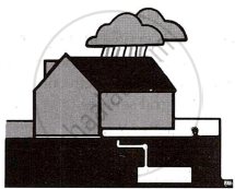
- Name the water conservation practice shown in the above picture.
- How does this system help to reduce floods?
- Why is water conservation necessary? (Any two reasons)
Chapter:
Name any three varieties of coal produced in India.
Chapter:
Name the variety of coal widely used in Iron and Steel Industries of India.
Chapter:
Name the state that is the largest producer of iron ore in India.
Chapter:
Name any one mining area of Iron ore from the odisha state.
Chapter: [7] Mineral and Energy Resources
Mention two ways in which Hirakud dam has helped the people of Odisha?
Chapter:
Give reason for the following:
Geothermal energy is not popular in India.
Chapter:
Give reason for the following:
Solar energy is gaining popularity.
Chapter:
Give reason for the following:
Petroleum is considered a harmful source of energy.
Chapter:
Why is agriculture considered an important sector of Indian economy? (Any two points)
Chapter:
Give one reason to explain the following:
West Bengal is a leading producer of jute.
Chapter:
Advertisements
Give one reason to explain the following:
Millets are fast becoming the popular food crops.
Chapter:
Give one reason to explain the following:
More than two ratoon crops are not advisable for sugarcane farmers.
Chapter:
With reference to tea cultivation, explain the term 'fine pluck.'
Chapter:
Name the Indian state that leads in coffee production.
Chapter:
Based on the ownership, what type of industry is Vishakhapatnam Steel Plant?
Chapter:
Explain the following term:
Sericulture
Chapter: [9] Manufacturing Industries
Explain the following term:
Integrated steel plant.
Chapter:
Give one reason to explain the following:
Mini-steel plants help in conservation of coal.
Chapter:
Give one reason to explain the following:
Location of sugar industry is shifting to the southern part of India.
Chapter:
Give one reason to explain the following:
The electronic industry is growing at a fast rate.
Chapter:
State two conditions that favour the location of cotton textile industry in Ahmedabad.
Chapter: [9] Manufacturing Industries
State any one advantage of locating Iron and Steel industry at Rourkela.
Chapter:
Why is road transport an important means of transport in India? (Any two reasons)
Chapter:
Give a reason for the following:
Northern plain is best suited for the development of Railways.
Chapter:
Give a reason for the following:
Railways are managed completely by the Central Government.
Chapter:
Mention two advantages of Inland water transport.
Chapter:
Mention one disadvantage of Inland water transport.
Chapter:
Why has airway become more popular than other means of transport? (Any three reasons)
Chapter:
With reference to the picture below, answer the questions that follow:
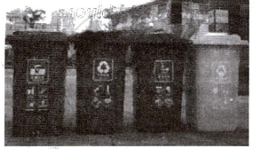
- Which waste management method is depicted here?
- State one way in which this method may be implemented at our home.
Chapter:
Explain how waste accumulation can be harmful. (Any two points)
Chapter:
Explain how waste generated in the household sector may be made useful. (Give one example)
Chapter:
Explain how waste generated in the industry sector may be made useful. (Give one example)
Chapter:
Explain how waste generated in the agriculture sector may be made useful. (Give one example)
Chapter:
Why are landfills set up far away from the city? (Any two reasons)
Chapter:
Other Solutions
Submit Question Paper
Help us maintain new question papers on Shaalaa.com, so we can continue to help studentsonly jpg, png and pdf files
CISCE previous year question papers ICSE Class 10 Geography with solutions 2023 - 2024
Previous year Question paper for CISCE ICSE Class 10 -2024 is solved by experts. Solved question papers gives you the chance to check yourself after your mock test.
By referring the question paper Solutions for Geography, you can scale your preparation level and work on your weak areas. It will also help the candidates in developing the time-management skills. Practice makes perfect, and there is no better way to practice than to attempt previous year question paper solutions of CISCE ICSE Class 10 .
How CISCE ICSE Class 10 Question Paper solutions Help Students ?
• Question paper solutions for Geography will helps students to prepare for exam.
• Question paper with answer will boost students confidence in exam time and also give you an idea About the important questions and topics to be prepared for the board exam.
• For finding solution of question papers no need to refer so multiple sources like textbook or guides.
