Advertisements
Advertisements
Question
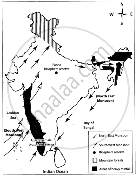
Mark the following on the outline map of India.
- Direction of South West Monsoon wind.
- Direction of North East Monsoon wind.
- Areas of heavy rainfall.
- Mountain forests.
- Panna biosphere reserve
- Agasthiyamalai biosphere reserve
Advertisements
Solution
APPEARS IN
RELATED QUESTIONS
Choose the right answer from the alternative given below.
Which one of the following places receives the highest rainfall in the world?
Give reason as to why.
Parts of Rajasthan, Gujarat and the leeward side of the Western Ghats are drought-prone.
These forests are found along the rivers on Khadar areas:
The Himalayas act not only as physical barrier but also as ______.
What is the effect of latitude on the climate of India?
State whether right or wrong.
Temperature decreases from north to south in India.
On an outline map of India, show the following.
- Areas receiving rainfall over 400 cm.
- Areas receiving less than 20 cm of rainfall.
- The direction of the south-west monsoon over India.
Collect photographs of typical rural houses and clothing of people from different regions of India. Examine whether they reflect any relationship with the climatic condition and relief of the area.
Now think why Leh has moderate precipitation almost throughout the year?
In spite of these facts see carefully if there is strong evidence to conclude that the monsoons still provide a very strong framework lending overall climatic unity to the whole country.
India's climate is of ______ type.
