Advertisements
Advertisements
प्रश्न
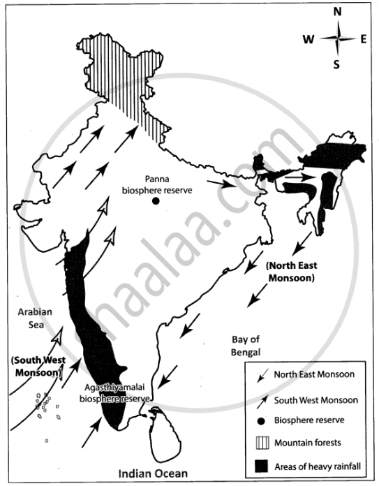
Mark the following on the outline map of India.
- Direction of South West Monsoon wind.
- Direction of North East Monsoon wind.
- Areas of heavy rainfall.
- Mountain forests.
- Panna biosphere reserve
- Agasthiyamalai biosphere reserve
नकाशा
Advertisements
उत्तर
shaalaa.com
या प्रश्नात किंवा उत्तरात काही त्रुटी आहे का?
APPEARS IN
संबंधित प्रश्न
Choose the right answer from the alternative given below.
The wind blowing in the Northern Plains in the summers is known as
Explain the importance of the Himalayas and the Indian Ocean with respect to the climate of India.
We wear cotton during ______.
Match the following
| 1. | Sundarbans | Desert and semi desert vegetation |
| 2. | Biodiversity hotspot | October - December |
| 3. | North east monsoon | Littoral forest |
| 4. | Tropical thorn forests | West Beangal |
| 5. | Coastal forests | The Himalayas |
Match the following
| 1. | Project Elephant | Desert and semi desert vegetation |
| 2. | Biodiversity | Otober -December |
| 3. | North east monsoon | Littoral forest |
| 4. | Tropical thorn forest | Protect the elephants |
| 5. | Coastal forests | The Himalayas |
The Predominant soil in the coastal plains and north Indian Plains is ______.
Mark the following in the outline map of India supplied to you. Write the names. Give Index
- Sikkim
- Lakshadweep Island
- Chennai Port
- Mineral oil refineries in Assam-Digboi
- Any one southern state with high density of population
- Tropic of Cancer
Why the houses in Rajasthan have thick walls and flat roofs?
Choose the odd man out:
Region with very high rainfall in India.
Study the climate data of Station X and answer the questions that follow:
| Month | JAN | FEB | MAR | APR | MAY | JUNE | JULY | AUG | SEPT | OCT | NOV | DEC |
| Temp. °C | 8.4 | 11.5 | 21.6 | 28.3 | 35.1 | 38.5 | 41.0 | 38.0 | 30.8 | 29.2 | 15.6 | 10.2 |
| Rainfall in cms | 1.5 | 0.9 | 0.5 | - | - | 12.5 | 17.8 | 18.5 | 12.5 | 12.5 | 6.2 | 2.1 |
- Calculate the annual range of temperature of Station X.
- Name the rainiest month of the Station X.
- Is the Station X located in coastal area or in the continental interior?
