Advertisements
Advertisements
प्रश्न
Match the following
| 1. | Sundarbans | Desert and semi desert vegetation |
| 2. | Biodiversity hotspot | October - December |
| 3. | North east monsoon | Littoral forest |
| 4. | Tropical thorn forests | West Beangal |
| 5. | Coastal forests | The Himalayas |
Advertisements
उत्तर
| 1. | Sundarbans | West Beangal |
| 2. | Biodiversity hotspot | The Himalayas |
| 3. | North east monsoon | October - December |
| 4. | Tropical thorn forests | Desert and semi desert vegetation |
| 5. | Coastal forests | Littoral forest |
APPEARS IN
संबंधित प्रश्न
Give geographical reasons:
Convectional type of rainfall is not prominent in India.
Match the Column I with Column II.
| Column I | Column II | |
| A. | Equable climate | Climatic barrier |
| B. | Western Ghats | Windward side |
| C. | Peninsular region | British climate |
| D. | Manglore | Leeward side |
| E. | bengaluru | Maritime climate |
Match the Column I with Column II.
| Column I | Column II | |
| A. | Tropical evergreen forest | Sandal wood |
| B. | Tropical Deciduous forest | Oak, silver fir |
| C. | Alpine forest | Black buck |
| D. | Tidal forest | Casuarina |
| E. | Coastal forest | Mahogany |
| F. | State animal of Andhra Pradesh, Pujab and Haryana | Mangrove trees |
The Himalayas act not only as physical barrier but also as ______.
Which part of India experiences the highest range of temperature in a day?
Where is monsoon experienced mainly?
Which important endangered animal is found in the jungles of Assam and West Bengal?
State whether right or wrong.
Temperature decreases from north to south in India.
Observe the following graph and answer the questions given below:
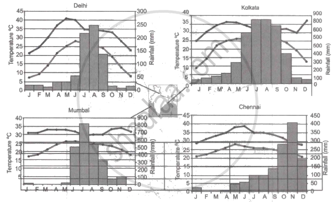
Note: In the graphs, the dark line represents the max. temperature and the lighter line represents min. temperature. The bars represent the amount of rainfall every month in each city.
- Where in the four cities is the rainfall heaviest?
- Which city has the most rainfall throughout the year?
- Which city experiences the highest temperature?
- Calculate the average range of minimum and maximum temperature for all four cities.
- What do the temperature curves in Delhi indicate?
- What is the condition of Mumbai during monsoons?
Study the climate data of Station X and answer the questions that follow:
| Month | JAN | FEB | MAR | APR | MAY | JUNE | JULY | AUG | SEPT | OCT | NOV | DEC |
| Temp. °C | 8.4 | 11.5 | 21.6 | 28.3 | 35.1 | 38.5 | 41.0 | 38.0 | 30.8 | 29.2 | 15.6 | 10.2 |
| Rainfall in cms | 1.5 | 0.9 | 0.5 | - | - | 12.5 | 17.8 | 18.5 | 12.5 | 12.5 | 6.2 | 2.1 |
- Calculate the annual range of temperature of Station X.
- Name the rainiest month of the Station X.
- Is the Station X located in coastal area or in the continental interior?
