Advertisements
Advertisements
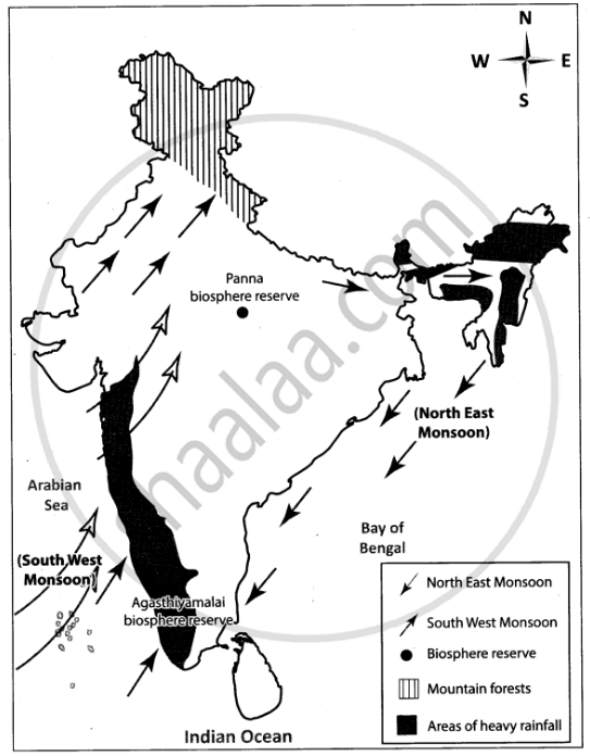
प्रश्न
Mark the following on the outline map of India.
- Direction of South West Monsoon wind.
- Direction of North East Monsoon wind.
- Areas of heavy rainfall.
- Mountain forests.
- Panna biosphere reserve
- Agasthiyamalai biosphere reserve
Advertisements
उत्तर
APPEARS IN
संबंधित प्रश्न
Choose the right answer from the alternative given below.
The wind blowing in the Northern Plains in the summers is known as
Consider the given statements and choose the correct option from the given below ones.
Assertion(A): Monsoons are a complex meteorological phenomenon.
Reason(R): Meteorologists have developed a number of concepts about the origin of monsoons.
The Coastal areas enjoy climate.
Shrub vegetation is found in ______.
Match the Column I with Column II.
| Column I | Column II | |
| A. | Western Disturbance | Driest place on Earth |
| B. | Norwesters | North East monson |
| C. | Burst of monsoon | Bihar- Assam |
| D. | Cyclonic Depression | Marine Biosphere Reserve |
| E. | Gulf of mannar | South west monsoon |
| F. | Atacama desert | Punjab - Haryana |
Which regions of India still has natural vegetation in real sense?
What is the effect of latitude on the climate of India?
Now think why Jodhpur has a hot desert type of climate?
In spite of these facts see carefully if there is strong evidence to conclude that the monsoons still provide a very strong framework lending overall climatic unity to the whole country.
Mark the following in the outline map of India supplied to you. Write the names. Give Index
- Sikkim
- Lakshadweep Island
- Chennai Port
- Mineral oil refineries in Assam-Digboi
- Any one southern state with high density of population
- Tropic of Cancer
Why houses in Assam are built on stilts?
