Advertisements
Advertisements
प्रश्न
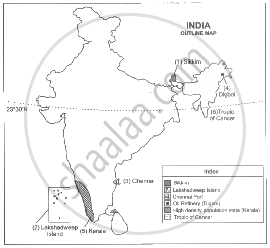
Mark the following in the outline map of India supplied to you. Write the names. Give Index
- Sikkim
- Lakshadweep Island
- Chennai Port
- Mineral oil refineries in Assam-Digboi
- Any one southern state with high density of population
- Tropic of Cancer
Advertisements
उत्तर
APPEARS IN
संबंधित प्रश्न
Consider the given statements and choose the correct option from the given below ones.
Assertion(A): Monsoons are a complex meteorological phenomenon.
Reason(R): Meteorologists have developed a number of concepts about the origin of monsoons.
The variation on______elements give rise to variety of vegetation.
In the upper layers of the troposphere ______ are found.
Match the Column I with Column II.
| Column I | Column II | |
| A. | Equable climate | Climatic barrier |
| B. | Western Ghats | Windward side |
| C. | Peninsular region | British climate |
| D. | Manglore | Leeward side |
| E. | bengaluru | Maritime climate |
The Himalayas act not only as physical barrier but also as ______.
What kind of Vegetation is supported by the sandy soil of the desert?
Collect photographs of typical rural houses and clothing of people from different regions of India. Examine whether they reflect any relationship with the climatic condition and relief of the area.
Now think why Leh has moderate precipitation almost throughout the year?
In spite of these facts see carefully if there is strong evidence to conclude that the monsoons still provide a very strong framework lending overall climatic unity to the whole country.
Why the houses in Rajasthan have thick walls and flat roofs?
Study the climate data of Station X and answer the questions that follow:
| Month | JAN | FEB | MAR | APR | MAY | JUNE | JULY | AUG | SEPT | OCT | NOV | DEC |
| Temp. °C | 8.4 | 11.5 | 21.6 | 28.3 | 35.1 | 38.5 | 41.0 | 38.0 | 30.8 | 29.2 | 15.6 | 10.2 |
| Rainfall in cms | 1.5 | 0.9 | 0.5 | - | - | 12.5 | 17.8 | 18.5 | 12.5 | 12.5 | 6.2 | 2.1 |
- Calculate the annual range of temperature of Station X.
- Name the rainiest month of the Station X.
- Is the Station X located in coastal area or in the continental interior?
