Advertisements
Advertisements
Question
Observe the following graph and answer the questions given below:
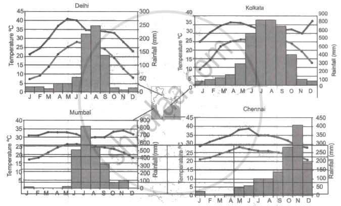
Note: In the graphs, the dark line represents the max. temperature and the lighter line represents min. temperature. The bars represent the amount of rainfall every month in each city.
- Where in the four cities is the rainfall heaviest?
- Which city has the most rainfall throughout the year?
- Which city experiences the highest temperature?
- Calculate the average range of minimum and maximum temperature for all four cities.
- What do the temperature curves in Delhi indicate?
- What is the condition of Mumbai during monsoons?
Advertisements
Solution
- Kolkata receives the heaviest rainfall among the four cities.
- Kolkata receives the most rainfall throughout the year.
- Delhi experiences the highest temperature.
- The minimum and maximum range of temperatures are:
(i) Delhi: Maximum - 20°C; Minimum - 22°C
(ii) Kolkata: Maximum - 12°C; Minimum - 18°C
(iii) Mumbai: Maximum - 3°C; Minimum - 9°C
(iv) Chennai: Maximum - 10°C; Minimum - 7°C - The temperature curves of Delhi show that the city experiences extreme temperatures.
- Mumbai receives heavy rainfall during the months of monsoon.
APPEARS IN
RELATED QUESTIONS
India’s climate is of ______________ type
Compare the climates of Brazil and India.
In the coastal areas ______ plateau act as a barrier.
Match the Column I with Column II.
| Column I | Column II | |
| A. | Equable climate | Climatic barrier |
| B. | Western Ghats | Windward side |
| C. | Peninsular region | British climate |
| D. | Manglore | Leeward side |
| E. | bengaluru | Maritime climate |
Match the Column I with Column II.
| Column I | Column II | |
| A. | Tropical evergreen forest | Sandal wood |
| B. | Tropical Deciduous forest | Oak, silver fir |
| C. | Alpine forest | Black buck |
| D. | Tidal forest | Casuarina |
| E. | Coastal forest | Mahogany |
| F. | State animal of Andhra Pradesh, Pujab and Haryana | Mangrove trees |
The Himalayas act not only as physical barrier but also as ______.
Write a short note.
Comparison of the climate of India and Brazil.
Why does the coromandal coast face frequent cyclones?
Observe the given figure and write the answers.
 |
- Which region gets more than 4000 mm of rainfall?
- Identify the regions with maximum and minimum temperatures?
- In which direction is the temperature increasing?
- Identify the direction of the winds shown. What are they known as?
- Which winds are responsible for the rainfall in India ?
- Some part of Rajasthan is under desert? What could be the reason for it?
- Draw the main parallel of latitude passing through India which affects its climate.
- In which part of Peninsular India are semi-arid climatic conditions found and why?
Study the climatic data of station X and answer the following questions:
| Month | Jan | Feb | Mar | Apr | May | Jun | July | Aug | Sep | Oct | Nov | Dec |
| Temp (°C) | 23.1 | 24.8 | 26.5 | 29.3 | 32 | 32.8 | 33.1 | 32.1 | 30.5 | 29.3 | 28.7 | 26.1 |
| Rainfall (cm) | 7.3 | 1.1 | 0.3 | 0.1 | 1.3 | 4.5 | 6.1 | 8.2 | 8.5 | 20.1 | 20.8 | 9.0 |
- What is the annual range of temperature of station X?
- Which is the driest month?
- Name the wind that brings maximum rainfall to this station.
