Advertisements
Advertisements
Question
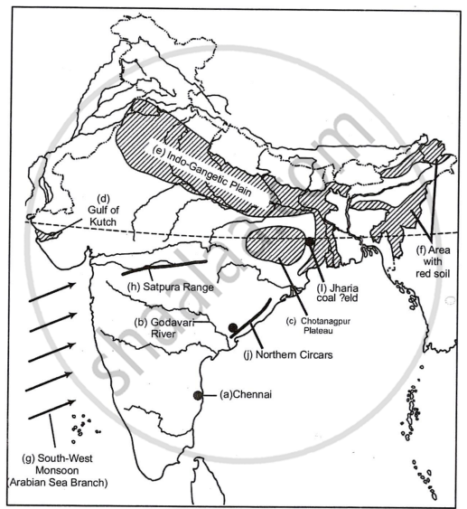
On the outline map of India provided:
(a) Mark and name Chennai
(b) Label the river Godavari
(c) Shade and label the Chhota Nagpur Plateau
(d) Shade and name the Gulf of Kachchh
(e) Mark and name the Indo-Gangetic Plains
(f) Shade and label an area with Red Soil
(g) Mark and name the winds which bring rain to Mumbai in July and August
(h) Mark and name the Satpura Range
(i) Mark and name the Jharia Coal Field
(j) Shade and label the Northern Circar coastal region
Advertisements
Solution 1

Solution 2
APPEARS IN
RELATED QUESTIONS
On an outline map of India provided:
(a) Draw and name the Tropic of Cancer.
(b) Label the river Godavari.
(c) Mark and name the Garo Hills.
(d) Mark C on the coal fields of Jharia.
(e) Mark with an arrow and name the NE monsoon over the Bay of Bengal.
(f) Shade and name the Gulf of Kutch.
(g) Shade and name the coastal plain that receives rainfall in October and November.
(h) Mark with a dot and name Delhi.
(i) Shade a region with Black Cotton Soil.
(j) Use an arrow to point at a densely populated state in South India.
Name two features which makes Dantrai a more important settlement than the other settlement in the map extract.
On the outline map of India provided:
a) Draw, name and number the Standard Meridian.
b) Label the river Yamuna.
c) Shade and label the Gulf of Khambhat.
d) Mark and name the Nathu-La Pass.
e) Mark and name the Karakoram Range.
f) Shade and name a sparsely populated State in Northeast India.
g) Shade a region with laterite soil in Eastern India.
h) Mark with a dot and name Vishakhapatnam.
i) Mark and name the winds that bring rain to West Bengal in summer.
j) Print S on the iron mines in Singhbhum.
By what name is the parallel of latitude 23° 33′ known? Name the zones or belts into which it divides India almost equally.
Why is the Pamir Knot known as ‘the roof of the world’.
On the outline map provided:
(a) Shade and label the country Nepal.
(b) Shade and label an area of black soil in India.
(c) Mark and label the Konkan Coast.
(d) Shade and label one region of winter rainfall in India.
(e) Sade and label the Sulaiman Ranges.
(f) Label the River Yamuna.
(g) Label the River Tapti.
(h) Shade and label the Vindhya Ranges.
Show the following on the outline map provided:
(a) Shade and label the Satpura Range.
(b) Label the River Krishna.
(c) Label the River Ravi.
(d) Shade and label the Khasi Hills.
(e) Mark with arrows the direction of the North-East Monsoon winds over the Bay of Bengal.
(f) Mark and label the Malabar coast.
(g) Shade and label an area of Laterite soil in India.
(h) Shade and label an area of Limestone in India.
On the outline map of the Indian sub-continent provided to you at the end of this question paper:
(i) Mark with a bold line and label:
(a) The Karakoram Range.
(b) The Eastern Ghats.
(c) The Nilgiris
(ii) Shade and name one region for the : Black soil.
(iii) Mark and label:
(a) The Khyber Pass
(b) The capital city of Assam.
(c) River Godavari.
(iv) (a) Identify, shade and name:
(1) A region of sparse population (less than 50 pp sq.) in North-Eastern India.
(2) A region of ‘Equatorial Forests’.
(b) Mark with one long arrow, the direction of the Summer Monsoon over the Bay of Bengal.
On the map of India,
(a) Label the Konkan Coast, Malabar Coast and the Coromandel Coast in their proper places.
(b) Shade and name the Rann of Kutch.
(c) Mark and name the Ajanta Range.
(d) Mark and name the Khasi-Jaintia Hills.
(e) Mark and name the Patkoi Hills.
(f) Mark and name the Naga Hills.
(g) Mark and name the Cardamom Hills.
(h) Mark and name the Annamalai Hills. Name its highest peak, Anaimudi.
On the outline map of India provided:
- Mark and label the river Krishna.
- Mark and label the Eastern Ghats.
- Shade and label a densely populated area in the southern part of India.
- Shade and label the Konkan coastal plain.
- Mark with an arrow and label the direction of western disturbance.
- Shade and label the Thar Desert.
- Shade and label the Andaman Sea.
- Mark and label the city Chennai.
- Mark and name the highest peak of Himalayas in India.
- Mark and label Mumbai High.
