Advertisements
Advertisements
Question
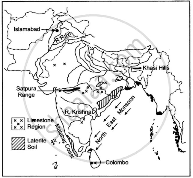
Show the following on the outline map provided:
(a) Shade and label the Satpura Range.
(b) Label the River Krishna.
(c) Label the River Ravi.
(d) Shade and label the Khasi Hills.
(e) Mark with arrows the direction of the North-East Monsoon winds over the Bay of Bengal.
(f) Mark and label the Malabar coast.
(g) Shade and label an area of Laterite soil in India.
(h) Shade and label an area of Limestone in India.
Advertisements
Solution
APPEARS IN
RELATED QUESTIONS
On the outline map of India provided:
(a) Draw and number the Standard Meridian of India.
(b) Label the river Mahanadi.
(c) Mark and name Lake Chilka.
(d) Shade and name the Gulf of Mannar.
(e) Mark and name the Vindhya Mountains.
(f) Shade and name a sparsely populated region in western India
(g) Shade a region with alluvial soil in South India.
(h) Mark and name Kolkata.
(i) Mark with arrows and name South West Monsoon winds over the Bay of Bengal.
(j) Mark and name Mumbai High.
Name one region shown on the map which is unsuitable for the cultivation of crops.
On the outline map of India provided:
a) Mark and name Chennai
b) Label the river Godavari
c) Shade and label the Chota Nagpur Plateau
d) Shade and name the Gulf of Kachchh
e) Mark and name the Indo Gangetic Plains
f) Shade and label the area with Red Soil
g) Mark and name the winds which bring rain to Mumbai in July and August
h) Mark and name the Satpura Range
i) Mark and name Jharia Coal Field
j) Shade and label the Northern Circar coastal region.
By what name is the parallel of latitude 23° 33′ known? Name the zones or belts into which it divides India almost equally.
On the outline map provided
(a) Label the river Chenab.
(b) Label the river Chambal.
(c) Shade and label the Nilgiri Hills.
(d) Mark and label the Eastern Ghats.
(e) Mark and name the port city of Pakistan.
(f) Mark and label Hyderabad.
(g) Shade and label the Sunderbans.
(h) Mark and name the Palk Strait.
(i) Mark and label a region North of the Tropic of Cancer where tea is grown extensively.
(j) Mark and name the winds which bring rain to Mumbai in July and August.
On the map of India.
(a) Mark and name the Himalaya Mountains.
(b) Mark and name the Passes : Bolan, Gomal, Shipkila (Shipki).
On the map of India,
(a) Label the Konkan Coast, Malabar Coast and the Coromandel Coast in their proper places.
(b) Shade and name the Rann of Kutch.
(c) Mark and name the Ajanta Range.
(d) Mark and name the Khasi-Jaintia Hills.
(e) Mark and name the Patkoi Hills.
(f) Mark and name the Naga Hills.
(g) Mark and name the Cardamom Hills.
(h) Mark and name the Annamalai Hills. Name its highest peak, Anaimudi.
On the map of India, mark with a dot and name the cities.
- The National Capital (Delhi).
- The Capital of Maharashtra, or the Commercial Capital of India (Mumbai).
- The Capital of West Bengal (Kolkata).
- The Capital of Tamil Nadu (Chennai).
- The Capital of Karnataka (Bangalore).
- The Capital of Andhra Pradesh (Hyderabad).
- The city whose local time is taken as the standard time of India (Allahabad).
- Vishakhapatnam.
- Kochi.
- Capital of Jammu-Kashmir (Srinagar).
Name the physical divisions into which India can be divided.
On the outline map of India provided:
- Mark and label the Satpura.
- Shade and label the Gulf of Kutch.
- Mark and label the River Chambal.
- Mark and label Delhi.
- Mark and label 80°30' E longitude.
- Mark and label Jharia Coalfield.
- Mark with arrows and name the Southwest Monsoon winds.
- Mark and label the Karakoram Pass.
- Shade and label a sparsely populated region in Western India.
- Shade an area having Alluvial soil.
