Advertisements
Advertisements
प्रश्न
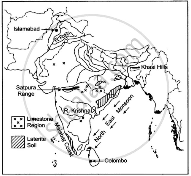
Show the following on the outline map provided:
(a) Shade and label the Satpura Range.
(b) Label the River Krishna.
(c) Label the River Ravi.
(d) Shade and label the Khasi Hills.
(e) Mark with arrows the direction of the North-East Monsoon winds over the Bay of Bengal.
(f) Mark and label the Malabar coast.
(g) Shade and label an area of Laterite soil in India.
(h) Shade and label an area of Limestone in India.
Advertisements
उत्तर
APPEARS IN
संबंधित प्रश्न
On the outline map of India provided:
a) Mark and name the Nilgiris.
b) Shade and label the Malwa Plateau.
c) Shade and label the Malabar Coastal Plains.
d) Mark and name the River Gomati.
e) Mark and name the Andaman Sea.
f) Mark and name Allahabad.
g) Mark with a single arrow and name the winds that bring winter rains to North West India.
h) Mark and name Digboi.
i) Mark an area with laterite soil below the Tropic of Cancer.
j) Mark and name the Karakoram Pass.
Name two features which makes Dantrai a more important settlement than the other settlement in the map extract.
What is the geographical name that you would give to the general pattern of settlement in the region shown on the map?
On the outline map of India provided:
a) Mark and name Chennai
b) Label the river Godavari
c) Shade and label the Chota Nagpur Plateau
d) Shade and name the Gulf of Kachchh
e) Mark and name the Indo Gangetic Plains
f) Shade and label the area with Red Soil
g) Mark and name the winds which bring rain to Mumbai in July and August
h) Mark and name the Satpura Range
i) Mark and name Jharia Coal Field
j) Shade and label the Northern Circar coastal region.
On the outline map of India provided:
(a) Shade and label the Gangetic Plain. [1]
(b) Shade and label an area of laterite soil in North India. [1]
(c) Mark and label the Karakoram Mountains. [1]
(d) Mark and name the Palk Strait. [1]
(e) Shade and label the river Cauveri. [1]
(f) Mark and name Mumbai. [1]
(g) Mark and name the Nathu La Pass. [1]
(h) Mark and name Digboi. [1]
(i) Shade and name the Deccan Plateau. [1]
(j) Shade and label the river Jhelum. [1]
On the outline map provided
(a) Label the river Chenab.
(b) Label the river Chambal.
(c) Shade and label the Nilgiri Hills.
(d) Mark and label the Eastern Ghats.
(e) Mark and name the port city of Pakistan.
(f) Mark and label Hyderabad.
(g) Shade and label the Sunderbans.
(h) Mark and name the Palk Strait.
(i) Mark and label a region North of the Tropic of Cancer where tea is grown extensively.
(j) Mark and name the winds which bring rain to Mumbai in July and August.
On the map of India.
(a) Mark and name the Himalaya Mountains.
(b) Mark and name the Passes : Bolan, Gomal, Shipkila (Shipki).
On the map of India, mark with a dot and name the cities.
- The National Capital (Delhi).
- The Capital of Maharashtra, or the Commercial Capital of India (Mumbai).
- The Capital of West Bengal (Kolkata).
- The Capital of Tamil Nadu (Chennai).
- The Capital of Karnataka (Bangalore).
- The Capital of Andhra Pradesh (Hyderabad).
- The city whose local time is taken as the standard time of India (Allahabad).
- Vishakhapatnam.
- Kochi.
- Capital of Jammu-Kashmir (Srinagar).
On the outline map of India provided:
- Mark and label the Satpura.
- Shade and label the Gulf of Kutch.
- Mark and label the River Chambal.
- Mark and label Delhi.
- Mark and label 80°30' E longitude.
- Mark and label Jharia Coalfield.
- Mark with arrows and name the Southwest Monsoon winds.
- Mark and label the Karakoram Pass.
- Shade and label a sparsely populated region in Western India.
- Shade an area having Alluvial soil.
On the outline map of India provided:
- Mark and label the river Krishna.
- Mark and label the Eastern Ghats.
- Shade and label a densely populated area in the southern part of India.
- Shade and label the Konkan coastal plain.
- Mark with an arrow and label the direction of western disturbance.
- Shade and label the Thar Desert.
- Shade and label the Andaman Sea.
- Mark and label the city Chennai.
- Mark and name the highest peak of Himalayas in India.
- Mark and label Mumbai High.
