Advertisements
Advertisements
Question
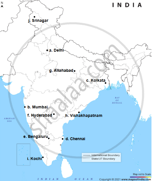
On the map of India, mark with a dot and name the cities.
- The National Capital (Delhi).
- The Capital of Maharashtra, or the Commercial Capital of India (Mumbai).
- The Capital of West Bengal (Kolkata).
- The Capital of Tamil Nadu (Chennai).
- The Capital of Karnataka (Bangalore).
- The Capital of Andhra Pradesh (Hyderabad).
- The city whose local time is taken as the standard time of India (Allahabad).
- Vishakhapatnam.
- Kochi.
- Capital of Jammu-Kashmir (Srinagar).
Advertisements
Solution
APPEARS IN
RELATED QUESTIONS
On the outline map of India provided:
- Shade and label Thar Desert.
- Label the river Narmada.
- Shade and name the Wular Lake.
- Shade and label Kanara coast.
- Mark and name Mount Kanchenjunga.
- Shade and label a densely-populated region in India.
- Shade and label a region with Red soil in India.
- Mark with a dot and name Chennai.
- Mark and label the Arabian Sea branch of S.W. Monsoon.
- Mark with a dot and name Singhbhum.
On the outline map of India provided:
a) Mark and name the Nilgiris.
b) Shade and label the Malwa Plateau.
c) Shade and label the Malabar Coastal Plains.
d) Mark and name the River Gomati.
e) Mark and name the Andaman Sea.
f) Mark and name Allahabad.
g) Mark with a single arrow and name the winds that bring winter rains to North West India.
h) Mark and name Digboi.
i) Mark an area with laterite soil below the Tropic of Cancer.
j) Mark and name the Karakoram Pass.
Calculate the area of the region which lies to the south of northing 21 in square kilometres.
On the outline map of India provided:
a) Mark and name Chennai
b) Label the river Godavari
c) Shade and label the Chota Nagpur Plateau
d) Shade and name the Gulf of Kachchh
e) Mark and name the Indo Gangetic Plains
f) Shade and label the area with Red Soil
g) Mark and name the winds which bring rain to Mumbai in July and August
h) Mark and name the Satpura Range
i) Mark and name Jharia Coal Field
j) Shade and label the Northern Circar coastal region.
On the outline map of India provided:
(a) Shade and label the Gangetic Plain. [1]
(b) Shade and label an area of laterite soil in North India. [1]
(c) Mark and label the Karakoram Mountains. [1]
(d) Mark and name the Palk Strait. [1]
(e) Shade and label the river Cauveri. [1]
(f) Mark and name Mumbai. [1]
(g) Mark and name the Nathu La Pass. [1]
(h) Mark and name Digboi. [1]
(i) Shade and name the Deccan Plateau. [1]
(j) Shade and label the river Jhelum. [1]
Why is the Pamir Knot known as ‘the roof of the world’.
Why is South Asia referred as Indian Sub-continent?
On the outline map provided:
(a) Shade and label the country Nepal.
(b) Shade and label an area of black soil in India.
(c) Mark and label the Konkan Coast.
(d) Shade and label one region of winter rainfall in India.
(e) Sade and label the Sulaiman Ranges.
(f) Label the River Yamuna.
(g) Label the River Tapti.
(h) Shade and label the Vindhya Ranges.
On the map of India,
- Mark and name the Shiwalik Range.
- Mark and name the Western Ghats with two gaps, Bhor Ghat and Palghat Gap.
- Mark and name the peak on the Karakoram Mts, (Mt. Godwin Austien or Mt. K2).
- Mark and name, the highest peak on the Himalayas, (Mt Everest).
- Mark and name Mt. Kanchenjunga.
- Mark and name the Maikal Range.
- Shade and name the Indo-Gangetic Plain.
On the outline map of India provided:
- Mark and label the Satpura.
- Shade and label the Gulf of Kutch.
- Mark and label the River Chambal.
- Mark and label Delhi.
- Mark and label 80°30' E longitude.
- Mark and label Jharia Coalfield.
- Mark with arrows and name the Southwest Monsoon winds.
- Mark and label the Karakoram Pass.
- Shade and label a sparsely populated region in Western India.
- Shade an area having Alluvial soil.
