Advertisements
Advertisements
प्रश्न
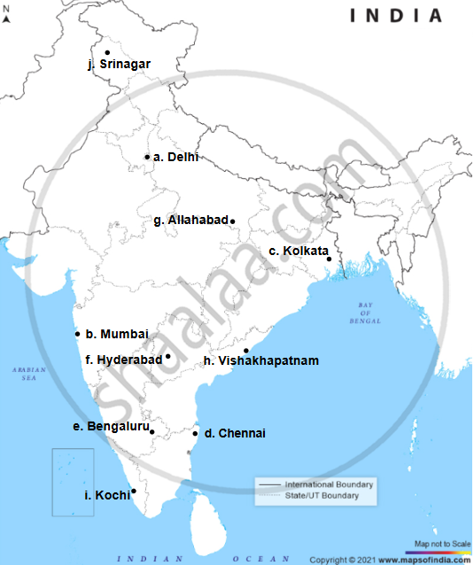
On the map of India, mark with a dot and name the cities.
- The National Capital (Delhi).
- The Capital of Maharashtra, or the Commercial Capital of India (Mumbai).
- The Capital of West Bengal (Kolkata).
- The Capital of Tamil Nadu (Chennai).
- The Capital of Karnataka (Bangalore).
- The Capital of Andhra Pradesh (Hyderabad).
- The city whose local time is taken as the standard time of India (Allahabad).
- Vishakhapatnam.
- Kochi.
- Capital of Jammu-Kashmir (Srinagar).
Advertisements
उत्तर
APPEARS IN
संबंधित प्रश्न
On the outline map of India provided:
(a) Draw and number the Standard Meridian of India.
(b) Label the river Mahanadi.
(c) Mark and name Lake Chilka.
(d) Shade and name the Gulf of Mannar.
(e) Mark and name the Vindhya Mountains.
(f) Shade and name a sparsely populated region in western India
(g) Shade a region with alluvial soil in South India.
(h) Mark and name Kolkata.
(i) Mark with arrows and name South West Monsoon winds over the Bay of Bengal.
(j) Mark and name Mumbai High.
Name two features which makes Dantrai a more important settlement than the other settlement in the map extract.
Calculate the area of the region which lies to the south of northing 21 in square kilometres.
On the outline map of India provided:
a) Draw, name and number the Standard Meridian.
b) Label the river Yamuna.
c) Shade and label the Gulf of Khambhat.
d) Mark and name the Nathu-La Pass.
e) Mark and name the Karakoram Range.
f) Shade and name a sparsely populated State in Northeast India.
g) Shade a region with laterite soil in Eastern India.
h) Mark with a dot and name Vishakhapatnam.
i) Mark and name the winds that bring rain to West Bengal in summer.
j) Print S on the iron mines in Singhbhum.
On the outline map of India provided:
(a) Shade and label the Gangetic Plain. [1]
(b) Shade and label an area of laterite soil in North India. [1]
(c) Mark and label the Karakoram Mountains. [1]
(d) Mark and name the Palk Strait. [1]
(e) Shade and label the river Cauveri. [1]
(f) Mark and name Mumbai. [1]
(g) Mark and name the Nathu La Pass. [1]
(h) Mark and name Digboi. [1]
(i) Shade and name the Deccan Plateau. [1]
(j) Shade and label the river Jhelum. [1]
Why is South Asia referred as Indian Sub-continent?
On the outline map of India provided:
(a) Draw, name and number the Standard Meridian.
(b) Label the river Yamuna.
(c) Shade and name the Gulf of Khambhat.
(d) Mark and name the Nathu-La Pass.
(e) Mark and name the Karakoram Range.
(f) Shade and name a sparsely populated State in Northeast India.
(g) Shade a region with laterite soil in Eastern India.
(h) Mark with a dot and name Vishakhapatnam.
(i) Mark and name the winds that bring rain to West Bengal in summer.
(j) Print S on the iron mines in Singhbhum.
(a) Mark and name Chennai
On the outline map of India provided:
(a) Mark and name Kochi.
(b) Label the river Krishna.
(c) Shade and label the Malwa Plateau.
(d) Mark and label the Konkan Coast.
(e) Shade and label the Gulf of Mannar.
(f) Shade and label an alluvial soil area in Peninsular India.
(g) Mark with arrows the direction of the Arabian Sea branch of South West Monsoon Winds.
(h) Shade and label the Western Ghats.
(i) Mark the Jharia coal field.
(j) Shade and name a densely populated area.
On the outline map of India provided:
- Mark and label the river Krishna.
- Mark and label the Eastern Ghats.
- Shade and label a densely populated area in the southern part of India.
- Shade and label the Konkan coastal plain.
- Mark with an arrow and label the direction of western disturbance.
- Shade and label the Thar Desert.
- Shade and label the Andaman Sea.
- Mark and label the city Chennai.
- Mark and name the highest peak of Himalayas in India.
- Mark and label Mumbai High.
On the outline map of India provided:
- Shade and label an area of alluvial soil in the north-east.
- Mark using a dot and name the commercial capital of India.
- Mark and name the highest peak of the Himalayas in India.
- Shade and label Gulf of Kutch.
- Mark with arrows and name the wind bringing rainfall to Punjab in the winter.
- Shade and label a sparsely populated area.
- Mark and label Eastern Ghats.
- Mark and name a tributary of an important peninsular river.
- Mark and label the most important latitude passing through the country.
- Mark and label Coromandel coast.
