Advertisements
Advertisements
प्रश्न
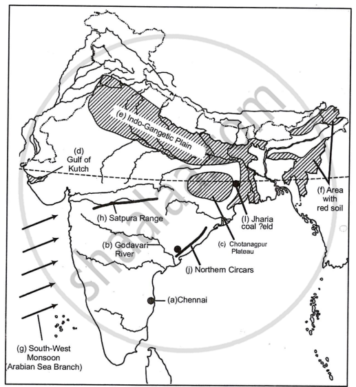
On the outline map of India provided:
(a) Mark and name Chennai
(b) Label the river Godavari
(c) Shade and label the Chhota Nagpur Plateau
(d) Shade and name the Gulf of Kachchh
(e) Mark and name the Indo-Gangetic Plains
(f) Shade and label an area with Red Soil
(g) Mark and name the winds which bring rain to Mumbai in July and August
(h) Mark and name the Satpura Range
(i) Mark and name the Jharia Coal Field
(j) Shade and label the Northern Circar coastal region
Advertisements
उत्तर १

उत्तर २
APPEARS IN
संबंधित प्रश्न
On an outline map of India provided:
(a) Draw and name the Tropic of Cancer.
(b) Label the river Godavari.
(c) Mark and name the Garo Hills.
(d) Mark C on the coal fields of Jharia.
(e) Mark with an arrow and name the NE monsoon over the Bay of Bengal.
(f) Shade and name the Gulf of Kutch.
(g) Shade and name the coastal plain that receives rainfall in October and November.
(h) Mark with a dot and name Delhi.
(i) Shade a region with Black Cotton Soil.
(j) Use an arrow to point at a densely populated state in South India.
On the outline map of India provided:
(a) Draw and number the Standard Meridian of India.
(b) Label the river Mahanadi.
(c) Mark and name Lake Chilka.
(d) Shade and name the Gulf of Mannar.
(e) Mark and name the Vindhya Mountains.
(f) Shade and name a sparsely populated region in western India
(g) Shade a region with alluvial soil in South India.
(h) Mark and name Kolkata.
(i) Mark with arrows and name South West Monsoon winds over the Bay of Bengal.
(j) Mark and name Mumbai High.
What is the value of the contour line in square 0226? What is the contour interval in the map?
What is the geographical name that you would give to the general pattern of settlement in the region shown on the map?
Name one region shown on the map which is unsuitable for the cultivation of crops.
On the outline map of India provided:
(a) Shade and label the Gangetic Plain. [1]
(b) Shade and label an area of laterite soil in North India. [1]
(c) Mark and label the Karakoram Mountains. [1]
(d) Mark and name the Palk Strait. [1]
(e) Shade and label the river Cauveri. [1]
(f) Mark and name Mumbai. [1]
(g) Mark and name the Nathu La Pass. [1]
(h) Mark and name Digboi. [1]
(i) Shade and name the Deccan Plateau. [1]
(j) Shade and label the river Jhelum. [1]
Show the following on the outline map provided:
(a) Shade and label the Satpura Range.
(b) Label the River Krishna.
(c) Label the River Ravi.
(d) Shade and label the Khasi Hills.
(e) Mark with arrows the direction of the North-East Monsoon winds over the Bay of Bengal.
(f) Mark and label the Malabar coast.
(g) Shade and label an area of Laterite soil in India.
(h) Shade and label an area of Limestone in India.
On the outline map of the Indian sub-continent provided to you at the end of this question paper:
(i) Mark with a bold line and label:
(a) The Karakoram Range.
(b) The Eastern Ghats.
(c) The Nilgiris
(ii) Shade and name one region for the : Black soil.
(iii) Mark and label:
(a) The Khyber Pass
(b) The capital city of Assam.
(c) River Godavari.
(iv) (a) Identify, shade and name:
(1) A region of sparse population (less than 50 pp sq.) in North-Eastern India.
(2) A region of ‘Equatorial Forests’.
(b) Mark with one long arrow, the direction of the Summer Monsoon over the Bay of Bengal.
On the map of India.
(a) Mark and name the Himalaya Mountains.
(b) Mark and name the Passes : Bolan, Gomal, Shipkila (Shipki).
On the outline map of India provided:
- Mark and label the Satpura.
- Shade and label the Gulf of Kutch.
- Mark and label the River Chambal.
- Mark and label Delhi.
- Mark and label 80°30' E longitude.
- Mark and label Jharia Coalfield.
- Mark with arrows and name the Southwest Monsoon winds.
- Mark and label the Karakoram Pass.
- Shade and label a sparsely populated region in Western India.
- Shade an area having Alluvial soil.
