Advertisements
Advertisements
प्रश्न
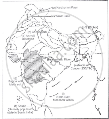
On the outline map of India provided:
- Draw, name and number the Tropic of Cance
- Label the river Narmada
- Shade and name Lake Chilka
- Shade and name Wular lake.
- Mark and name the Aravali Mountains
- Mark and name the Karakoram Pass
- Shade and name a densely populated state in South India
- Shade and name a region with black soil
- Mark with a dot and name Srinagar
- Mark with a dot and name Chandigarh
- Mark and name the winds which bring rain in winter to the Coromandel Coast
- Name and print O on an oilfield in North-east India.
Advertisements
उत्तर १

उत्तर २
APPEARS IN
संबंधित प्रश्न
On the outline map of India provided:
(a) Draw and number the Standard Meridian of India.
(b) Label the river Mahanadi.
(c) Mark and name Lake Chilka.
(d) Shade and name the Gulf of Mannar.
(e) Mark and name the Vindhya Mountains.
(f) Shade and name a sparsely populated region in western India
(g) Shade a region with alluvial soil in South India.
(h) Mark and name Kolkata.
(i) Mark with arrows and name South West Monsoon winds over the Bay of Bengal.
(j) Mark and name Mumbai High.
On the outline map of India provided:
a) Draw, name and number the Standard Meridian.
b) Label the river Yamuna.
c) Shade and label the Gulf of Khambhat.
d) Mark and name the Nathu-La Pass.
e) Mark and name the Karakoram Range.
f) Shade and name a sparsely populated State in Northeast India.
g) Shade a region with laterite soil in Eastern India.
h) Mark with a dot and name Vishakhapatnam.
i) Mark and name the winds that bring rain to West Bengal in summer.
j) Print S on the iron mines in Singhbhum.
On the outline map of India provided:
(a) Shade and label the Gangetic Plain. [1]
(b) Shade and label an area of laterite soil in North India. [1]
(c) Mark and label the Karakoram Mountains. [1]
(d) Mark and name the Palk Strait. [1]
(e) Shade and label the river Cauveri. [1]
(f) Mark and name Mumbai. [1]
(g) Mark and name the Nathu La Pass. [1]
(h) Mark and name Digboi. [1]
(i) Shade and name the Deccan Plateau. [1]
(j) Shade and label the river Jhelum. [1]
On the outline map of India provided:
(a) Mark and name Chennai
(b) Label the river Godavari
(c) Shade and label the Chhota Nagpur Plateau
(d) Shade and name the Gulf of Kachchh
(e) Mark and name the Indo-Gangetic Plains
(f) Shade and label an area with Red Soil
(g) Mark and name the winds which bring rain to Mumbai in July and August
(h) Mark and name the Satpura Range
(i) Mark and name the Jharia Coal Field
(j) Shade and label the Northern Circar coastal region
On the outline map of the Indian sub-continent provided to you at the end of this question paper:
(i) Mark with a bold line and label:
(a) The Karakoram Range.
(b) The Eastern Ghats.
(c) The Nilgiris
(ii) Shade and name one region for the : Black soil.
(iii) Mark and label:
(a) The Khyber Pass
(b) The capital city of Assam.
(c) River Godavari.
(iv) (a) Identify, shade and name:
(1) A region of sparse population (less than 50 pp sq.) in North-Eastern India.
(2) A region of ‘Equatorial Forests’.
(b) Mark with one long arrow, the direction of the Summer Monsoon over the Bay of Bengal.
On the map of India.
(a) Mark and name the Himalaya Mountains.
(b) Mark and name the Passes : Bolan, Gomal, Shipkila (Shipki).
On the map of India,
(a) Label the Konkan Coast, Malabar Coast and the Coromandel Coast in their proper places.
(b) Shade and name the Rann of Kutch.
(c) Mark and name the Ajanta Range.
(d) Mark and name the Khasi-Jaintia Hills.
(e) Mark and name the Patkoi Hills.
(f) Mark and name the Naga Hills.
(g) Mark and name the Cardamom Hills.
(h) Mark and name the Annamalai Hills. Name its highest peak, Anaimudi.
On the map of India,
- Mark and name the Shiwalik Range.
- Mark and name the Western Ghats with two gaps, Bhor Ghat and Palghat Gap.
- Mark and name the peak on the Karakoram Mts, (Mt. Godwin Austien or Mt. K2).
- Mark and name, the highest peak on the Himalayas, (Mt Everest).
- Mark and name Mt. Kanchenjunga.
- Mark and name the Maikal Range.
- Shade and name the Indo-Gangetic Plain.
On the outline map of India provided:
- Mark and label the Satpura.
- Shade and label the Gulf of Kutch.
- Mark and label the River Chambal.
- Mark and label Delhi.
- Mark and label 80°30' E longitude.
- Mark and label Jharia Coalfield.
- Mark with arrows and name the Southwest Monsoon winds.
- Mark and label the Karakoram Pass.
- Shade and label a sparsely populated region in Western India.
- Shade an area having Alluvial soil.
On the outline map of India provided:
- Mark and label the river Krishna.
- Mark and label the Eastern Ghats.
- Shade and label a densely populated area in the southern part of India.
- Shade and label the Konkan coastal plain.
- Mark with an arrow and label the direction of western disturbance.
- Shade and label the Thar Desert.
- Shade and label the Andaman Sea.
- Mark and label the city Chennai.
- Mark and name the highest peak of Himalayas in India.
- Mark and label Mumbai High.
