Advertisements
Advertisements
Question
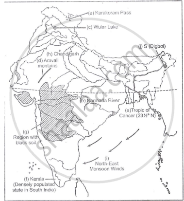
On the outline map of India provided:
- Draw, name and number the Tropic of Cance
- Label the river Narmada
- Shade and name Lake Chilka
- Shade and name Wular lake.
- Mark and name the Aravali Mountains
- Mark and name the Karakoram Pass
- Shade and name a densely populated state in South India
- Shade and name a region with black soil
- Mark with a dot and name Srinagar
- Mark with a dot and name Chandigarh
- Mark and name the winds which bring rain in winter to the Coromandel Coast
- Name and print O on an oilfield in North-east India.
Advertisements
Solution 1

Solution 2
APPEARS IN
RELATED QUESTIONS
On the outline map of India provided:
(a) Draw and number the Standard Meridian of India.
(b) Label the river Mahanadi.
(c) Mark and name Lake Chilka.
(d) Shade and name the Gulf of Mannar.
(e) Mark and name the Vindhya Mountains.
(f) Shade and name a sparsely populated region in western India
(g) Shade a region with alluvial soil in South India.
(h) Mark and name Kolkata.
(i) Mark with arrows and name South West Monsoon winds over the Bay of Bengal.
(j) Mark and name Mumbai High.
On the outline map of India provided:
a) Mark and name the Nilgiris.
b) Shade and label the Malwa Plateau.
c) Shade and label the Malabar Coastal Plains.
d) Mark and name the River Gomati.
e) Mark and name the Andaman Sea.
f) Mark and name Allahabad.
g) Mark with a single arrow and name the winds that bring winter rains to North West India.
h) Mark and name Digboi.
i) Mark an area with laterite soil below the Tropic of Cancer.
j) Mark and name the Karakoram Pass.
What is the geographical name that you would give to the general pattern of settlement in the region shown on the map?
Name one region shown on the map which is unsuitable for the cultivation of crops.
By what name is the parallel of latitude 23° 33′ known? Name the zones or belts into which it divides India almost equally.
On the outline map of India provided:
(a) Mark and name Chennai
(b) Label the river Godavari
(c) Shade and label the Chhota Nagpur Plateau
(d) Shade and name the Gulf of Kachchh
(e) Mark and name the Indo-Gangetic Plains
(f) Shade and label an area with Red Soil
(g) Mark and name the winds which bring rain to Mumbai in July and August
(h) Mark and name the Satpura Range
(i) Mark and name the Jharia Coal Field
(j) Shade and label the Northern Circar coastal region
On the map of India,
(a) Label the Konkan Coast, Malabar Coast and the Coromandel Coast in their proper places.
(b) Shade and name the Rann of Kutch.
(c) Mark and name the Ajanta Range.
(d) Mark and name the Khasi-Jaintia Hills.
(e) Mark and name the Patkoi Hills.
(f) Mark and name the Naga Hills.
(g) Mark and name the Cardamom Hills.
(h) Mark and name the Annamalai Hills. Name its highest peak, Anaimudi.
On the map of India,
- Mark and name the Shiwalik Range.
- Mark and name the Western Ghats with two gaps, Bhor Ghat and Palghat Gap.
- Mark and name the peak on the Karakoram Mts, (Mt. Godwin Austien or Mt. K2).
- Mark and name, the highest peak on the Himalayas, (Mt Everest).
- Mark and name Mt. Kanchenjunga.
- Mark and name the Maikal Range.
- Shade and name the Indo-Gangetic Plain.
On the map of India, mark with a dot and name the cities.
- The National Capital (Delhi).
- The Capital of Maharashtra, or the Commercial Capital of India (Mumbai).
- The Capital of West Bengal (Kolkata).
- The Capital of Tamil Nadu (Chennai).
- The Capital of Karnataka (Bangalore).
- The Capital of Andhra Pradesh (Hyderabad).
- The city whose local time is taken as the standard time of India (Allahabad).
- Vishakhapatnam.
- Kochi.
- Capital of Jammu-Kashmir (Srinagar).
Name the physical divisions into which India can be divided.
