Advertisements
Advertisements
प्रश्न
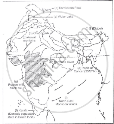
On the outline map of India provided:
- Draw, name and number the Tropic of Cance
- Label the river Narmada
- Shade and name Lake Chilka
- Shade and name Wular lake.
- Mark and name the Aravali Mountains
- Mark and name the Karakoram Pass
- Shade and name a densely populated state in South India
- Shade and name a region with black soil
- Mark with a dot and name Srinagar
- Mark with a dot and name Chandigarh
- Mark and name the winds which bring rain in winter to the Coromandel Coast
- Name and print O on an oilfield in North-east India.
Advertisements
उत्तर १

उत्तर २
APPEARS IN
संबंधित प्रश्न
On an outline map of India provided:
(a) Draw and name the Tropic of Cancer.
(b) Label the river Godavari.
(c) Mark and name the Garo Hills.
(d) Mark C on the coal fields of Jharia.
(e) Mark with an arrow and name the NE monsoon over the Bay of Bengal.
(f) Shade and name the Gulf of Kutch.
(g) Shade and name the coastal plain that receives rainfall in October and November.
(h) Mark with a dot and name Delhi.
(i) Shade a region with Black Cotton Soil.
(j) Use an arrow to point at a densely populated state in South India.
On the outline map of India provided:
(a) Draw and number the Standard Meridian of India.
(b) Label the river Mahanadi.
(c) Mark and name Lake Chilka.
(d) Shade and name the Gulf of Mannar.
(e) Mark and name the Vindhya Mountains.
(f) Shade and name a sparsely populated region in western India
(g) Shade a region with alluvial soil in South India.
(h) Mark and name Kolkata.
(i) Mark with arrows and name South West Monsoon winds over the Bay of Bengal.
(j) Mark and name Mumbai High.
On the outline map of India provided:
a) Mark and name the Nilgiris.
b) Shade and label the Malwa Plateau.
c) Shade and label the Malabar Coastal Plains.
d) Mark and name the River Gomati.
e) Mark and name the Andaman Sea.
f) Mark and name Allahabad.
g) Mark with a single arrow and name the winds that bring winter rains to North West India.
h) Mark and name Digboi.
i) Mark an area with laterite soil below the Tropic of Cancer.
j) Mark and name the Karakoram Pass.
Name two features which makes Dantrai a more important settlement than the other settlement in the map extract.
On the outline map of India provided:
(a) Mark and name Chennai
(b) Label the river Godavari
(c) Shade and label the Chhota Nagpur Plateau
(d) Shade and name the Gulf of Kachchh
(e) Mark and name the Indo-Gangetic Plains
(f) Shade and label an area with Red Soil
(g) Mark and name the winds which bring rain to Mumbai in July and August
(h) Mark and name the Satpura Range
(i) Mark and name the Jharia Coal Field
(j) Shade and label the Northern Circar coastal region
On the outline map of India provided:
(a) Mark and name Kochi.
(b) Label the river Krishna.
(c) Shade and label the Malwa Plateau.
(d) Mark and label the Konkan Coast.
(e) Shade and label the Gulf of Mannar.
(f) Shade and label an alluvial soil area in Peninsular India.
(g) Mark with arrows the direction of the Arabian Sea branch of South West Monsoon Winds.
(h) Shade and label the Western Ghats.
(i) Mark the Jharia coal field.
(j) Shade and name a densely populated area.
On the outline map provided:
(a) Shade and label the country Nepal.
(b) Shade and label an area of black soil in India.
(c) Mark and label the Konkan Coast.
(d) Shade and label one region of winter rainfall in India.
(e) Sade and label the Sulaiman Ranges.
(f) Label the River Yamuna.
(g) Label the River Tapti.
(h) Shade and label the Vindhya Ranges.
On the map of India,
- Mark and name the Shiwalik Range.
- Mark and name the Western Ghats with two gaps, Bhor Ghat and Palghat Gap.
- Mark and name the peak on the Karakoram Mts, (Mt. Godwin Austien or Mt. K2).
- Mark and name, the highest peak on the Himalayas, (Mt Everest).
- Mark and name Mt. Kanchenjunga.
- Mark and name the Maikal Range.
- Shade and name the Indo-Gangetic Plain.
On the map of India, mark with a dot and name the cities.
- The National Capital (Delhi).
- The Capital of Maharashtra, or the Commercial Capital of India (Mumbai).
- The Capital of West Bengal (Kolkata).
- The Capital of Tamil Nadu (Chennai).
- The Capital of Karnataka (Bangalore).
- The Capital of Andhra Pradesh (Hyderabad).
- The city whose local time is taken as the standard time of India (Allahabad).
- Vishakhapatnam.
- Kochi.
- Capital of Jammu-Kashmir (Srinagar).
Name the physical divisions into which India can be divided.
