Advertisements
Advertisements
Question
On an outline map of India, show the following.
- Areas receiving rainfall over 400 cm.
- Areas receiving less than 20 cm of rainfall.
- The direction of the south-west monsoon over India.
Advertisements
Solution
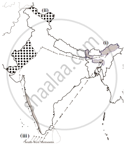
- The Western Coast and NorthEastern India receive rainfall over 400 cm. Mawsynram and Cherrapunji in Meghalaya are known for receiving maximum rainfall in the world. The Andaman Islands and Lakshadweep Islands are also known to receive annual rainfall above 400 cm.
- The parts of Northern Kashmir, Western Rajasthan, Deccan plateau, and Punjab are known to be the areas that receive scanty rainfall that is less than 20 cm. In the Northern part of India, rainfall decreases toward the west, while in the peninsular region except for Tamil Nadu, the rainfall decreases eastwards.
- South-west monsoon is a compound and a self-evolved weather system unique to the Indian subcontinent. The south west monsoon in India moves in south-west direction. In India, there are only south-west and north-east monsoons. Because of the Coriolis effect, the south-east monsoon becomes south-west trade winds.
RELATED QUESTIONS
Give geographical reasons:
Convectional type of rainfall is not prominent in India.
Explain the importance of the Himalayas and the Indian Ocean with respect to the climate of India.
The mighty ______ in the north play a vital role in influencing the climate of India.
Which regions of India still has natural vegetation in real sense?
Which important endangered animal is found in the jungles of Assam and West Bengal?
Match the following:
| A | B | ||
| 1. | Manaus | a. | Low rainfall region |
| 2. | Rajasthan | b. | Nucleated settlements |
| 3. | Highlands of Brazil | c. | Bengal Tiger |
| 4. | North Indian Plains | d. | Animals of grasslands |
| e. | Swampy region | ||
| f. | Not much difference in the range of temperature |
Now think why Jodhpur has a hot desert type of climate?
In spite of these facts see carefully if there is strong evidence to conclude that the monsoons still provide a very strong framework lending overall climatic unity to the whole country.
Now think why Leh has moderate precipitation almost throughout the year?
In spite of these facts see carefully if there is strong evidence to conclude that the monsoons still provide a very strong framework lending overall climatic unity to the whole country.
Observe the following graph and answer the questions given below:
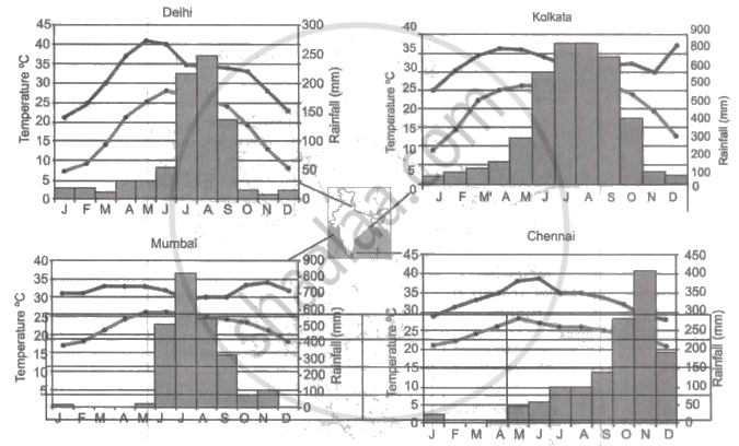
Note: In the graphs, the dark line represents the max. temperature and the lighter line represents min. temperature. The bars represent the amount of rainfall every month in each city.
- Where in the four cities is the rainfall heaviest?
- Which city has the most rainfall throughout the year?
- Which city experiences the highest temperature?
- Calculate the average range of minimum and maximum temperature for all four cities.
- What do the temperature curves in Delhi indicate?
- What is the condition of Mumbai during monsoons?
Why houses in Assam are built on stilts?
