Advertisements
Advertisements
प्रश्न
On an outline map of India, show the following.
- Areas receiving rainfall over 400 cm.
- Areas receiving less than 20 cm of rainfall.
- The direction of the south-west monsoon over India.
Advertisements
उत्तर
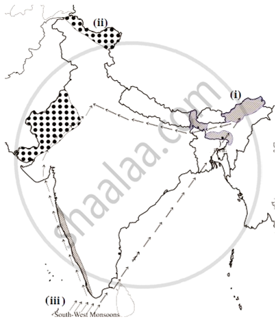
- The Western Coast and NorthEastern India receive rainfall over 400 cm. Mawsynram and Cherrapunji in Meghalaya are known for receiving maximum rainfall in the world. The Andaman Islands and Lakshadweep Islands are also known to receive annual rainfall above 400 cm.
- The parts of Northern Kashmir, Western Rajasthan, Deccan plateau, and Punjab are known to be the areas that receive scanty rainfall that is less than 20 cm. In the Northern part of India, rainfall decreases toward the west, while in the peninsular region except for Tamil Nadu, the rainfall decreases eastwards.
- South-west monsoon is a compound and a self-evolved weather system unique to the Indian subcontinent. The south west monsoon in India moves in south-west direction. In India, there are only south-west and north-east monsoons. Because of the Coriolis effect, the south-east monsoon becomes south-west trade winds.
APPEARS IN
संबंधित प्रश्न
State whether right or wrong. Rewrite the wrong sentence.
India faces tropical cyclones frequently.
Match the following.
| 1. | Rubber and Mahogany | Western Himalayas |
| 2. | Sandwood and rosewood | Eastern Himalayan Forest |
| 3. | Oak, birch, Silver | Coastal forest |
| 4. | Casurina, Palm and coconut | Deciduous forest |
| 5. | Sal, Semal, Jamun and Jujube | Evergreen forest |
Match the Column I with Column II.
| Column I | Column II | |
| A. | Western Disturbance | Driest place on Earth |
| B. | Norwesters | North East monson |
| C. | Burst of monsoon | Bihar- Assam |
| D. | Cyclonic Depression | Marine Biosphere Reserve |
| E. | Gulf of mannar | South west monsoon |
| F. | Atacama desert | Punjab - Haryana |
The mighty ______ in the north play a vital role in influencing the climate of India.
The pressure belts and the wind systems follow the apparent movements of the ______.
State whether right or wrong.
Location of India is in tropics.
State whether right or wrong.
Temperature decreases from north to south in India.
Observe the following graph and answer the questions given below:
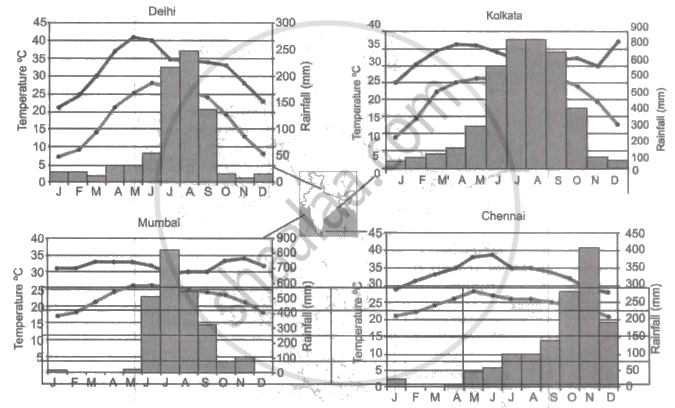
Note: In the graphs, the dark line represents the max. temperature and the lighter line represents min. temperature. The bars represent the amount of rainfall every month in each city.
- Where in the four cities is the rainfall heaviest?
- Which city has the most rainfall throughout the year?
- Which city experiences the highest temperature?
- Calculate the average range of minimum and maximum temperature for all four cities.
- What do the temperature curves in Delhi indicate?
- What is the condition of Mumbai during monsoons?
Why the houses in Rajasthan have thick walls and flat roofs?
Study the climatic data of station X and answer the following questions:
| Month | Jan | Feb | Mar | Apr | May | Jun | July | Aug | Sep | Oct | Nov | Dec |
| Temp (°C) | 23.1 | 24.8 | 26.5 | 29.3 | 32 | 32.8 | 33.1 | 32.1 | 30.5 | 29.3 | 28.7 | 26.1 |
| Rainfall (cm) | 7.3 | 1.1 | 0.3 | 0.1 | 1.3 | 4.5 | 6.1 | 8.2 | 8.5 | 20.1 | 20.8 | 9.0 |
- What is the annual range of temperature of station X?
- Which is the driest month?
- Name the wind that brings maximum rainfall to this station.
