Advertisements
Advertisements
Question
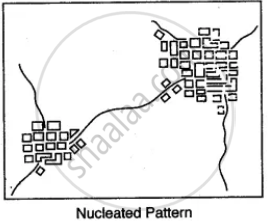
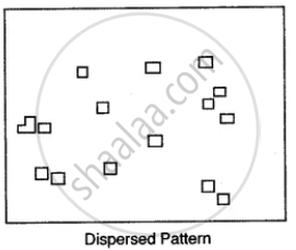
Name the various types of settlement patterns found on toposheet.
Advertisements
Solution

APPEARS IN
RELATED QUESTIONS
Name one offshore oil field of India
What is the difference between the pattern of settlements in 0725 and the settlement of Idarla?
Name two natural features in 0325.
State the direction in which this left bank tributary is flowing
Name the types of drainage pattern found in grid square 9374.
Why do you find limited cultivation in the map extract? Give two reasons for your answer
What is a Nodal centre?
Study the extract of the Survey of India Map sheet No. 45D/10 and answer the following questions:
(a) Give the six figure grid reference of:
(i) Triangulated height 217
(ii) A lined well near Chekhla.
(b)
(i) Name the left bank tributary of the main river.
(ii) State the direction in which this left bank tributary is flowing.
(c)
(i) Mention a special feature associated with the streams in grid square 9879.
(ii) Name the types of drainage pattern found in grid square 9382.
(d) Give the four grid reference of each of the following:
(i) Open scrub
(ii) Bantawada.
(e) Name two relief features that can be seen in grid square 9782 and 9574.
(f) Why do you find limited cultivation in the map extract?
(g) What is the compass direction of Antroli (9576) and Chekhla (9281) from Sangla?
(h) What type of rainfall is experienced in the region shown in the map extract? Justify your answer giving one reason.
(i) Calculate the distance in kilometres along the cart track between Chitrasani (999747) and Pirojpura (978753).
(j)
(i) What is the geographical name that you would give to the general pattern of settlements in the region shown on the map?
(ii) Name one region shown on the map which is unsuitable for the cultivation of crops.
If you are interpreting the cultural features from a topographical sheet, what information would you like to seek and how would you derive this information? Discuss with the help of suitable examples.
Identify the survey sheet of your city. Make a list of the important features both man-made and natural.
