Advertisements
Advertisements
Question
Give the meanings of the important terms used in toposheets.
Advertisements
Solution
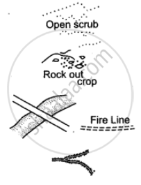
Open Scrub: It is the land where nothing grows. It is a sign of desert area. It indicates occupation as sheep or goat rearing.
Rock Outcrop: It is an exposed part of rock. Cultivation is not possible.
Sheet Rock: It is a mass or slab of rock, a portion of which is exposed above the surface. Shown in white it is also printed so.
Fire Line: A clearing is made in the forest to check the spread of fire.
Causeway: Causeway is a raised road or platform across a minor stream (not to be confused with a bridge). Its presence indicates areas of scanty or seasonal rainfall. Stream having causeway is motorable during dry season.
Broken Ground: It is the weathered part of the land caused due to erosion during heavy rain at the time of flooding. It is found mostly in dry regions around streams and rivers. On toposheet it is shown by tiny curved black line.
Aqueduct: It is a channel through which water flows.
Quarry: It is a pit from which limestone, marble, rock, sand or clay is obtained for building or other purposes.
Lime Kiln: It is a plant for manufacturing lime. Lime is used for making mortar which is used in holding bricks together.
Dry Well: The word ‘dry’ written in brackets near a well denotes a well that is dry in the dry season.
Brackish Well: The word ‘brackish’ written in brackets near a well means that the water in the well has a high salt content and is not fit for drinking. May be used for irrigation.
APPEARS IN
RELATED QUESTIONS
Name the following: An offshore oil field in the Gulf of Cambay.
What is the difference between the drainage pattern of the streams in 0624 and those in 0824?
What are the following?
302 in grid square 0425
Give the six figure grid reference of Triangulated height 217
Calculate the distance in kilometres along the cart track between Chitrasani (999747) and Pirojpura (978753).
What do you understand by the term Grid?
(i) What is the importance of a Relief Map.
(ii) How can we show occupations by the evidences of names or by inference of relief features?
Study the extract of Survey of India Map Sheet No. 45D/7 and answer the following questions.
(a) What do you understand by Eastings and Northings?
(b) Give the meaning of each of the following conventional symbols located in the grid square 1622.
(i) 20r (ii) PO
(c) What is the general direction of flow of the Sipu Nadi, given in the map extract? Give one reason to support your answer.
(d) Give the six-figure grid reference of:
(i) The point where the canal leaves the earth work, dam market 10r.
(ii) The spot height 1425 in the South-east corner of the map extract.
(e) Andhra is a better developed settlement than Gulabganj. Give two reasons.
(f) Account for the necessity of ‘fireline’ in the jungle area of the given map extract.
(g)
(i) What main purpose is solved by most of the wells in grid square 1621?
(ii) Why is the water in some of these wells not suitable for drinking?
(h) Name two probable occupations of the people in the settlement of Tokra in squares 2220 and 2221.
(i) What is the total length of canal in metres?
(j) Give the angular distance of the temple in Pithapura in 2022 from Bhumi Margi hill top.
If you are interpreting the cultural features from a topographical sheet, what information would you like to seek and how would you derive this information? Discuss with the help of suitable examples.
Identify the survey sheet of your city. Make a list of the important features both man-made and natural.
