Advertisements
Advertisements
प्रश्न
Give the meanings of the important terms used in toposheets.
Advertisements
उत्तर
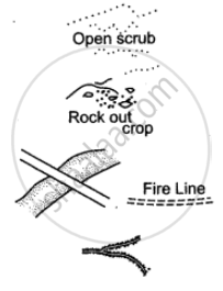
Open Scrub: It is the land where nothing grows. It is a sign of desert area. It indicates occupation as sheep or goat rearing.
Rock Outcrop: It is an exposed part of rock. Cultivation is not possible.
Sheet Rock: It is a mass or slab of rock, a portion of which is exposed above the surface. Shown in white it is also printed so.
Fire Line: A clearing is made in the forest to check the spread of fire.
Causeway: Causeway is a raised road or platform across a minor stream (not to be confused with a bridge). Its presence indicates areas of scanty or seasonal rainfall. Stream having causeway is motorable during dry season.
Broken Ground: It is the weathered part of the land caused due to erosion during heavy rain at the time of flooding. It is found mostly in dry regions around streams and rivers. On toposheet it is shown by tiny curved black line.
Aqueduct: It is a channel through which water flows.
Quarry: It is a pit from which limestone, marble, rock, sand or clay is obtained for building or other purposes.
Lime Kiln: It is a plant for manufacturing lime. Lime is used for making mortar which is used in holding bricks together.
Dry Well: The word ‘dry’ written in brackets near a well denotes a well that is dry in the dry season.
Brackish Well: The word ‘brackish’ written in brackets near a well means that the water in the well has a high salt content and is not fit for drinking. May be used for irrigation.
APPEARS IN
संबंधित प्रश्न
Name one offshore oil field of India
What are the following?
302 in grid square 0425
Name the types of drainage pattern found in grid square 9374.
What type of rainfall is experienced in the region shown in the map extract? Justify your answer giving one reason.
How is the importance of settlement reflected in a map?
What do you mean by ‘Marginal Information’?
Why are directions on a map important?
The area is measured by grid square method?
Study the extract of the Survey of India Map Sheet No. 45D/10 and answer the following questions: (Map G)
(a) Give the four-figure grid reference of:
(i) Dadarla (ii) Bhamra
(b) Which is the largest settlement shown on the map extract? Which one communication facility is exclusively available to this settlement?
(c) What does RF stand for? State the RF of the map provided to you.
(d) What is the total area of the actual ground represented in the map extract? (Show with the help of a simple calculation)
(e) What is meant by ‘contour interval’? State the contour interval of the toposheet provided to you
(f) State the highest and the lowest spot heights found on the map extract. Also mention whether they are in metres or in feet.
(g) Give the six-figure grid reference of:
(i) Spot height 339 (ii) Permanent hut located near Dhad Talao.
(h) What, according to you is the main (i) occupation, and (ii) religion of the people of the above area?
(i) Name one ‘natural’ and one ‘man-made’ source of irrigation used in this region.
(j) Name the general mode of transportation used in this region. What special feature of this mode is mentioned in the map extract?
Study the extract of the Survey of India Map Sheet No. 45 D/7 (A and B) and answer the following questions.
(a) Give the six figure grid reference of
(i) ∆ 277 (→) (ii) Lime kiln near Rampura (→) (iii) Stony waste (→).
(b) (i) What does the blue line in the Sipu river indicate?
(ii) In which village do you see the nodal function 7 What do you mean by this?
(c) (i) What does the black lines along the streams in the grid square 9199 indicate?
(ii) How are these features formed?
(iii) What type of region is shown in grid square 8696?
(d) Give the six-figure grid reference of the following:
(i) Lime Kiln near village Panswala.
(ii) Well with water near village Gonodara.
(iii) Dry tank near village Mohudi Moti.
(e) (i) What is the direction of the flow of Sipu river?
(ii) State why does it flow in this particular direction?
(f) Mention three natural features in the grid square 8998.
(g)
(i) What is the meaning of the term open scrub printed on the map.
(ii) How do you get an idea of the general nature of the slope in this area?
