Advertisements
Advertisements
प्रश्न
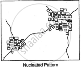
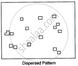
Name the various types of settlement patterns found on toposheet.
Advertisements
उत्तर

संबंधित प्रश्न
Name the following: An offshore oil field in the Gulf of Cambay.
Name the following:
An oil refinery in Bihar.
Mention one man-made feature in the map, which also provides evidence that the rainfall is seasonal.
Name the left bank tributary of the main river.
Why are directions on a map important?
Which colours are used on toposheets? What is their significance?
The distance is measured on the topographic map. There are two methods of measuring distance on the toposheets,
(i) Direct-method,
(ii) Indirect method.
Measuring straight distance is a direct method and measuring through a winding course is an indirect method. Explain both the methods.
Study the extract of the Survey of India Map sheet No. 45D/10 and answer the following questions:
- What is the compass direction of Sunset Point from the settlement of Anadra?
- What is the pattern of drainage in grid square 2315?
- Mention any two features seen in the map extract which indicate that the region has seasonal rainfall.
- Calculate the distance, in kilometers, along the metalled road from the causeway in grid square 1715 to the distance stone marked 20 in grid square 1818.
- What advantage does a Representative Fraction have over a verbal scale?
- Give the six figure grid reference of:
- Anjini Devi ka Mandir
- D 1327.
- Name the three different kinds of roads in grid square 2411 and the one in grid square 2515.
- Mention two occupations of the people living in the northern part of the region in the map extract. Give reasons to support your answer.
- What is the difference between the slope in grid square 2115 and the one in 1811? Give a reason for your answer.
- What is the purpose of:
- the fireline in grid square 2316.
- the pipeline in grid square 2209?
- What do the following represent?
- The red square in grid square 2514.
- 4r in grid square 1612,
- Abu is a popular holiday resort. Mention any three features seen in the map extract which attract holidaymakers to Abu.
Answer the following questions on the Survey Sheet Number 45 D/10. Eastings 00 to 10; Northings 17 to 28. (Map G)
(a) Give four-figure grid references of the following:
(i) Dhad Talao (ii) Sheet rock in the North-east
(iii) Rock outcrop in the North (iv) Stony waste in the South-east
(v) Open scrub south of Dhad Talao
(b) Give the six-figure grid references of the following:
(i) Police Chowki in village Dantral
(ii) Temple in Bhamra village
(iii) Well with water in settlement Devka
(iv) Spot height 310 near village Jolpur
(v) Tank near Indaria settlement
(c) Give-the direction of the following:
(i) Village Dantral (0324) from Dhann (0723)
(ii) Village Bhamra (0521) from Dhann (0723)
(iii) Village Jolpur (0718) from Malawa (0519)
(iv) Village Warka (0716) from Bikanwas (0316)
(v) Village Rampura (0617) from Dhann (0723)
(d) Give the meanings of the following:
(i) 15r in blue in grid square 0224.
(ii) 300 in brown in grid square 0426.
(iii) Black line in the northernmost part of the map.
(iv) Red line in grid square 0819.
(v) Black dots in grid square 0617.
(e) Give the settlement patterns of the following:
(i) Village Dhann (ii) In grid square 0220
(f) Measure the distances of the following:
(i) Direct distance in km. from Indaria (0826) to Jolpur (0718)
(ii) Indirect distance in km. along the cart track from Dantral (0324) to Dhann (0723)
(g) Give the drainage patterns of the following:
(i) 0827 (ii) In grid square 0226
(h) Name three man-made features found in grid square 0419 and draw their symbols.
(i) Give two evidences that the region gets seasonal rainfall.
(j) Explain the nature of the river.
(k) Explain the relief of the area.
(l) What is the general slope of the land? Give reason for your answer.
(m) What is the main occupation of the people? Give reason for your answer.
(n) What is the mode of irrigation? Give reasons for your answer.
(o) What is the mode of transport? Give reasons for your answer.
Study the extract of the Survey of India Map Sheet No. 45D/10 and answer the following questions: (Map G)
(a) Give the four-figure grid reference of:
(i) Dadarla (ii) Bhamra
(b) Which is the largest settlement shown on the map extract? Which one communication facility is exclusively available to this settlement?
(c) What does RF stand for? State the RF of the map provided to you.
(d) What is the total area of the actual ground represented in the map extract? (Show with the help of a simple calculation)
(e) What is meant by ‘contour interval’? State the contour interval of the toposheet provided to you
(f) State the highest and the lowest spot heights found on the map extract. Also mention whether they are in metres or in feet.
(g) Give the six-figure grid reference of:
(i) Spot height 339 (ii) Permanent hut located near Dhad Talao.
(h) What, according to you is the main (i) occupation, and (ii) religion of the people of the above area?
(i) Name one ‘natural’ and one ‘man-made’ source of irrigation used in this region.
(j) Name the general mode of transportation used in this region. What special feature of this mode is mentioned in the map extract?
