Advertisements
Advertisements
प्रश्न
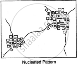
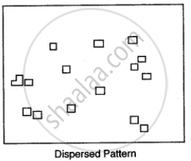
Name the various types of settlement patterns found on toposheet.
Advertisements
उत्तर

APPEARS IN
संबंधित प्रश्न
Name the state that produces the largest amount of limestone.
Give four grid reference of each of the following:
1) Open scrub
2) Bantawada
Why do you find limited cultivation in the map extract? Give two reasons for your answer
What type of rainfall is experienced in the region shown in the map extract? Justify your answer giving one reason.
What is a River system.
Calculate the average gradient along the two stations A and B, if the horizontal distance between them is 1,200 metres and the vertical difference in height is 240 metres.
What is a Nodal centre?
Study the extract of the Survey of India Map sheet No. 45D/10 and answer the following questions:
(a) Give the six figure grid reference of:
(i) Triangulated height 217
(ii) A lined well near Chekhla.
(b)
(i) Name the left bank tributary of the main river.
(ii) State the direction in which this left bank tributary is flowing.
(c)
(i) Mention a special feature associated with the streams in grid square 9879.
(ii) Name the types of drainage pattern found in grid square 9382.
(d) Give the four grid reference of each of the following:
(i) Open scrub
(ii) Bantawada.
(e) Name two relief features that can be seen in grid square 9782 and 9574.
(f) Why do you find limited cultivation in the map extract?
(g) What is the compass direction of Antroli (9576) and Chekhla (9281) from Sangla?
(h) What type of rainfall is experienced in the region shown in the map extract? Justify your answer giving one reason.
(i) Calculate the distance in kilometres along the cart track between Chitrasani (999747) and Pirojpura (978753).
(j)
(i) What is the geographical name that you would give to the general pattern of settlements in the region shown on the map?
(ii) Name one region shown on the map which is unsuitable for the cultivation of crops.
Study the extract of the Survey of India Map Sheet No. 45D/10 and answer the following questions: (Map G)
(a) Give the four-figure grid reference of:
(i) Dadarla (ii) Bhamra
(b) Which is the largest settlement shown on the map extract? Which one communication facility is exclusively available to this settlement?
(c) What does RF stand for? State the RF of the map provided to you.
(d) What is the total area of the actual ground represented in the map extract? (Show with the help of a simple calculation)
(e) What is meant by ‘contour interval’? State the contour interval of the toposheet provided to you
(f) State the highest and the lowest spot heights found on the map extract. Also mention whether they are in metres or in feet.
(g) Give the six-figure grid reference of:
(i) Spot height 339 (ii) Permanent hut located near Dhad Talao.
(h) What, according to you is the main (i) occupation, and (ii) religion of the people of the above area?
(i) Name one ‘natural’ and one ‘man-made’ source of irrigation used in this region.
(j) Name the general mode of transportation used in this region. What special feature of this mode is mentioned in the map extract?
Study the extract for topographical sheet 63K/12 shown in the figure below and answer the following questions.
- Give the height of the highest point on the map.
- River Jamtihwa Nadi is flowing through which quarter of the map?
- Which is the major settlement located in the east of the Kuardari Nala?
- What type of settlement does the area have?
- Name the geographical feature represented by white patches in the middle of Sipu Nadi.
- Name the two types of vegetation shown on part of the topographical sheet.
- What is the direction of the flow of the Kuardari?
- In which part of the sheet area is Lower Khajuri Dam located?
 R. F. 1: 50,000
Part of the Topographical Sheet No 63K/12
