Advertisements
Chapters
▶ 1: Interpretation of Topographical Maps
2: Map of India
UNIT 2: GEOGRAPHY OF INDIA
Chapter 3: Location, Extent and Physical Features of India
4: Climate of India
5: Soils in India
6: Natural Vegetation of India
7: Water Resources
8: Minerals and Energy Resources in India - Part I
9: Mineral and Energy Resources - Part II
10: Agriculture in India - Part 1
11: Agriculture in India Part II - Food Crops
12: Agriculture in India Part III - Cash Crops
13: Industries in India Part I - Agro Based Industries
14: Industries in India Part II - Mineral-Based Industries
15: Transport in India
16: Waste Management Part I - Impact of Waste Accumulation
17: Waste Management Part II - Need for Waste Management and Methods of Safe Disposal
18: Waste Management Part III - Need and Methods for Reducing, Reusing and Recycling Waste
![Austine Vas, Hemant M. Pednekar, Vidhya Malar solutions for जीआग्रफी ऑर अर्थ [अंग्रेजी] कक्षा १० आईसीएसई chapter 1 - Interpretation of Topographical Maps - Shaalaa.com](/images/geography-english-class-10-icse_6:4d4b3dbbabe34a99b001783cb7b5fbff.jpg "Austine Vas, Hemant M. Pednekar, Vidhya Malar solutions for जीआग्रफी ऑर अर्थ [अंग्रेजी] कक्षा १० आईसीएसई chapter 1 - Interpretation of Topographical Maps")
Advertisements
Solutions for Chapter 1: Interpretation of Topographical Maps
Below listed, you can find solutions for Chapter 1 of CISCE Austine Vas, Hemant M. Pednekar, Vidhya Malar for जीआग्रफी ऑर अर्थ [अंग्रेजी] कक्षा १० आईसीएसई.
Austine Vas, Hemant M. Pednekar, Vidhya Malar solutions for जीआग्रफी ऑर अर्थ [अंग्रेजी] कक्षा १० आईसीएसई 1 Interpretation of Topographical Maps Intext Questions [Pages 13 - 45]
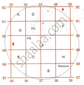
Using the above image give the four-figure grid reference for the following:
- Place A -
- Rampura -
- Place C -
 -
- -
-
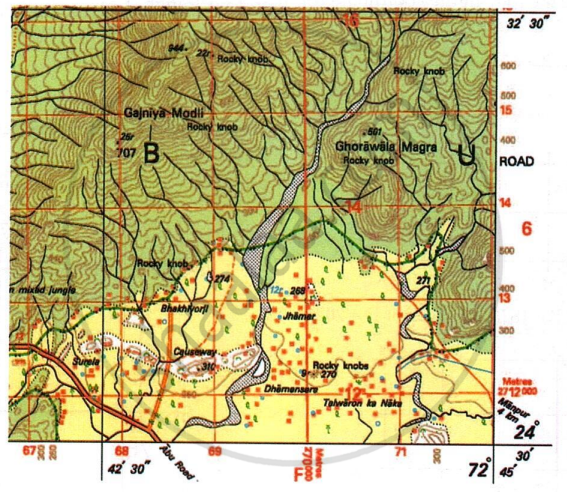
Using the above map extract, give six figure grid reference for the following:
- .501 (the six-figure of the dot has to be calculated)
- .310 (the six-figure of the dot has to be calculated)
- .270 (the six-figure of the dot has to be calculated)
Identify atleast five conventional signs and symbols (learnt so far) from the below topographical map extract.
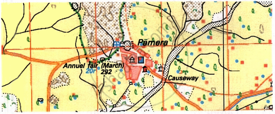
- ______
- ______
- ______
- ______
- ______
Identify the three important roads- National highway, state highway and district roads, from the below topographical map extract.
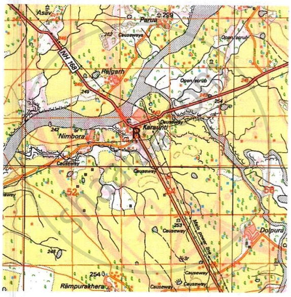
Study the extract of the topographical maр and answer the questions that follow:
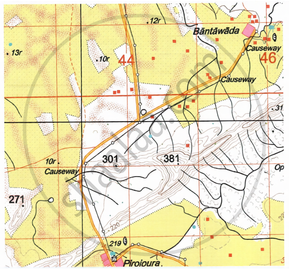
- When a person travels from Pirojpura to Bantawada:
- What type of road will he use?
- How will he cross where the streams cut the road?
- Is this road safe for travel during rainy season? Give reason for your answer.
- What is the meaning of a causeway?
Answer the following questions:
What is a contour line?
What is a contour interval?
What is the contour interval in the map with scale 1 : 50,000 given to you?
What are form lines?
How can you identify a gentle slope on a topographical map?
How can you identify a steep slope on a topographical map?
What is the colour of the contour line?
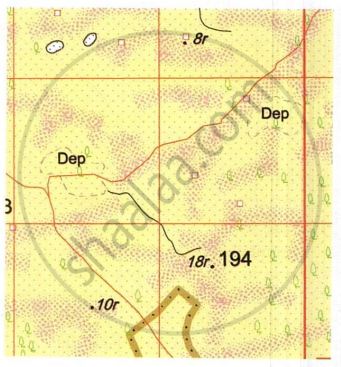
- What do the cluster of brown dots represent in the above map?
- What is the meaning of the words ‘Dep’ in the above map?
Answer the following questions:
Identify the drainage pattern in the below image
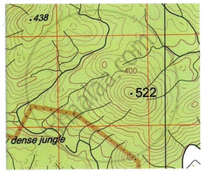
Identify the drainage pattern in the below image
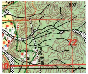
- What are the black broken lines seen in the below map?
- What do these black broken lines indicate about the soil in the region?
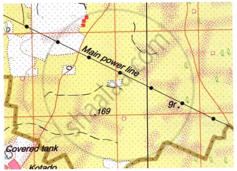
Answer the following questions:
What is the meaning of the word Brackish written near a well?
What is the symbol for a tube well?
How is a seasonal canal represented in a topographical map?
What is an aqueduct?
What is a sluice?
What is a siphon?
What is the symbol for overhead tank?
What is the purpose of covered tank?
What is the main source of irrigation for the people of Dantrai?
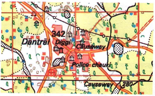
Name two perennial sources of water for the people of settlement Abu.
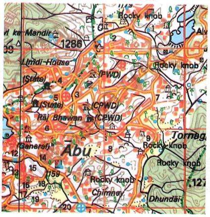
Answer the following questions:
What is the meaning of .313?
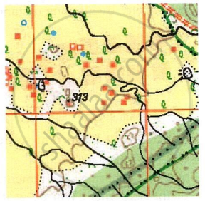
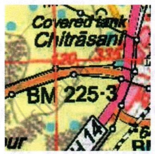
What is the meaning of BM 225.3?
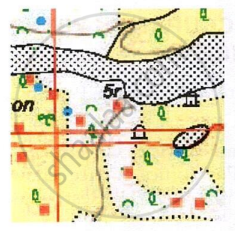
What is the meaning of 5r?
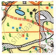
What is the meaning of 4r?
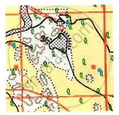
What is the meaning of 3r?
Answer the following questions.
What is the major occupation of the people other than agriculture in the given map extract?
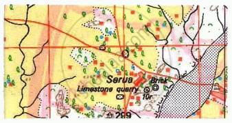
What is the major occupation of the people other than agriculture in the given map extract?
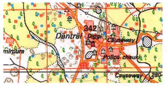
Which is the most important settlement in the given map? Give two reasons for your answer.
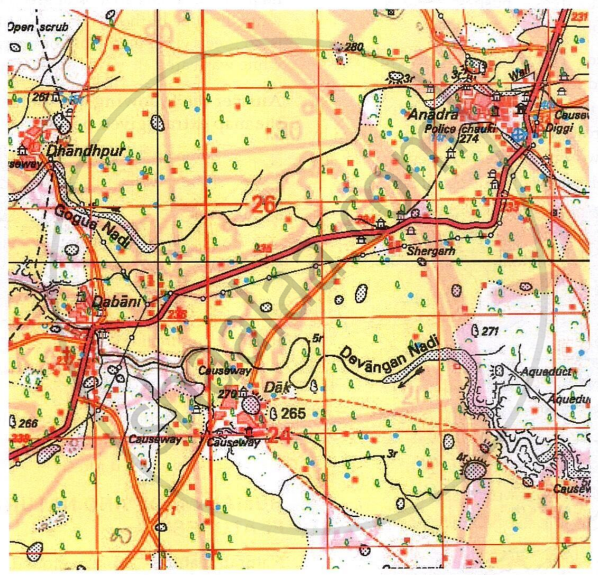
Answer the following questions using the map extract given below.
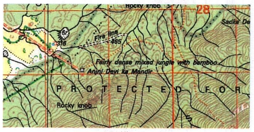
- What is a fire line?
- Do you think a fire line is necessary here? Give reason for your answer.
- Name one natural vegetation in the above map extract.
- What is a protected forest?
Identify two natural and two man-made features in the grid square 6912.
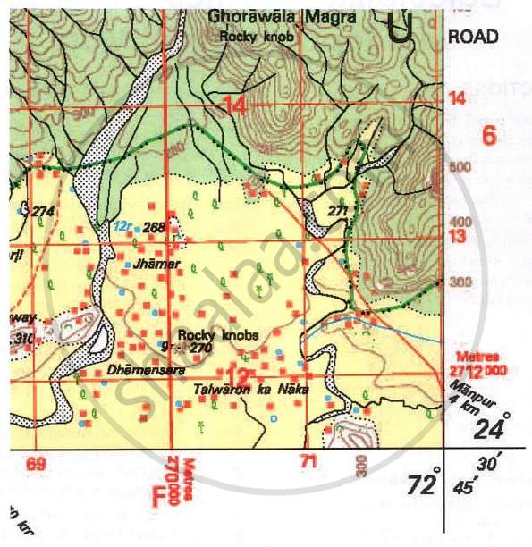
Study the below map and answer the questions that follow:
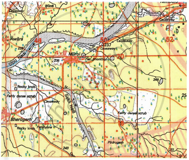
- What is the direction of the flow of Sukli nadi?
- On which bank of Sipu Nadi is the settlement Marol?
- What is the social activity of the people of settlement Marol?
- What do the white patches inside Sipu nadi indicate?
- Interpret the black curved lines seen on the side of Sipu nadi and Sukli nadi. What do they indicate about the rainfall in the region?
Give two features that have made Dattani an important settlement.
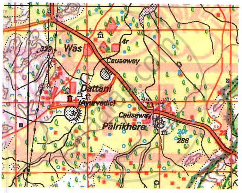
Observe the map extract given below and answer the questions that follow:
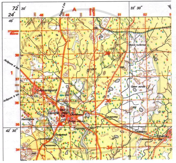
- What does the black vertical line between easting 51 and 52 represent?
- Interpret the black horizontal line between northing 34 and 35.
- What is the main mode of transport available at Dantrai?
- List the various amenities available in settlement Dantrai.
- How will the people of Dantrai cross the seasonal stream and reach the unmetalled road?
- Why do you think there are many causeways around settlement Dantrai?
- What is the significance of Diggi in 4835?
- What is the slope of the land in the given map extract? Give evidence for your answer.
Austine Vas, Hemant M. Pednekar, Vidhya Malar solutions for जीआग्रफी ऑर अर्थ [अंग्रेजी] कक्षा १० आईसीएसई 1 Interpretation of Topographical Maps Exercise 1 [Page 47]
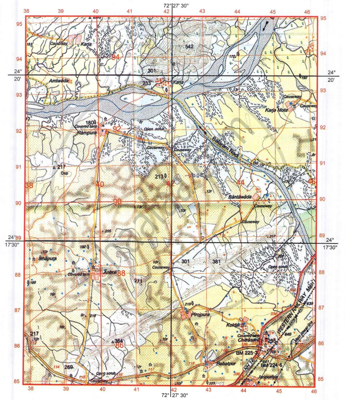
Study the extract of the Survey of India map sheet no: G43S7 - Map 1 and answer the following questions (Eastings 38 to 46, Northings 85 to 95):
-
- Give four figure grid reference for the post office in the south-east quarter of the map extract.
- What is the settlement pattern of Chitrasani?
-
- Which National Highway passes through Chitrasani?
- What is the six figure grid reference of the railway station?
- What are the two main sources of potable water in Chitrasani?
- With reference to the dark brown dots present on major parts of the map extract, what conclusions could one draw about the type of soil and climatic conditions of the region depicted?
-
- How does the metalled road cross seasonal stream in four figure grid reference 4389?
- What does number 192 in four figure grid reference 3988 represent?
- What is the direction of the flow of Balaram Nadi? On which bank of the main river does it join?
- What is the meaning of:
- 10r in 4289
- Blue line inside Banas river
- What is the drainage pattern in four figure grid references 4388 and 3986 respectively?
- What is the direction of the following:
- Antroli (4088) from Hebatpur (4385)?
- Δ 364 (4086) from Rampura (4092)?
- What is the area in km2 that lies to the south of Northing 87?
Austine Vas, Hemant M. Pednekar, Vidhya Malar solutions for जीआग्रफी ऑर अर्थ [अंग्रेजी] कक्षा १० आईसीएसई 1 Interpretation of Topographical Maps Exercise 2 [Page 49]
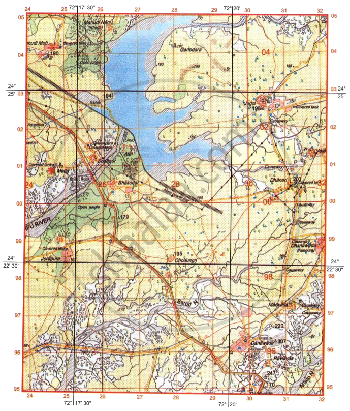
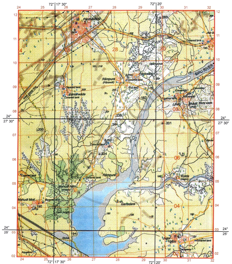
Study the extract of the Survey of India map sheet no: G4357 - Map 2 and answer the following questions (Eastings 24 to 32, Northings 95 to 05):
- What are the three types of Scales? Which among them is universally used?
-
- What do the black curved lines in four figure grid reference 2400 indicate?
- How is this feature formed?
-
- What is ‘Sheet Rock’?
- Give the four-figure grid reference of a ‘Sheet Rock’ in the map extract.
- Which quarter of the map extract has the lowest average height above mean sea level? Give reason for your answer.
-
- Identify two natural features in grid square in 2904.
- Identify two man-made features in grid square in 2998.
- What is the six-figure grid reference of the following:
- Δ 307?
- Lined Perennial well with a relative depth of 21 metres?
- Answer with reference to Sarod N.
- What is the nature of the river?
- What is the white patch inside the river?
- What is the direction of Jorapura (2498) from Mahudi Nani (2604) and from Dantiwada (2996), respectively?
- Name any two types of natural vegetation shown on the map extract.
-
- Identify the blue line passing through four figure grid reference 2402.
- What type of embankment is built across Sipu River to form the reservoir?
Austine Vas, Hemant M. Pednekar, Vidhya Malar solutions for जीआग्रफी ऑर अर्थ [अंग्रेजी] कक्षा १० आईसीएसई 1 Interpretation of Topographical Maps Exercise 3 [Page 51]
Study the extract of the Survey of India map sheet no: G43510 - Map 3 and answer the following questions (Eastings 63 to 71 and Northings 14 to 24):
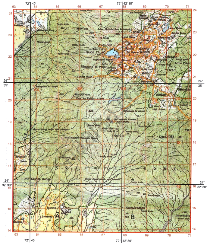
- What is RF? What is the RF given on the map extract?
- What is the four-figure grid reference of the following:
- Jain temples in the north?
- A burial ground closest to Nakhi Talao?
- Interpret the following in the four figure grids mentioned along:
- Falls 12 min 7019.
- 1327 Δ in 6721.
- What is the drainage pattern in four figure grids 6917 and in 6818 respectively?
- List two possible reasons why there isn’t direct metalled road connectivity between Abu in the north and the settlements in the southern part of the map extract.
- Give the six-figure grid reference of the following:
- Spot height 1277.
- Veterinary Hospital near Abu Town.
- What is the difference in the pattern of settlements between Abu in the north and Chandela in the south respectively?
- List any two reasons why Abu is a natural, tourism destination.
-
- What is the specialty of the well at Sakora (6317)?
- How many Tahsils or Talukas are shown on the map extract?
-
- Give one reason to say why the water of Nakhi Talao must not be used for potable purpose by the residents of Abu.
- What is the direction of Hetamiji from Nakhi Talao?
Austine Vas, Hemant M. Pednekar, Vidhya Malar solutions for जीआग्रफी ऑर अर्थ [अंग्रेजी] कक्षा १० आईसीएसई 1 Interpretation of Topographical Maps Exercise 4 [Page 53]
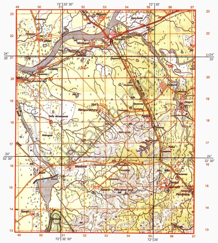
Study the extract of the Survey of India map sheet no: G43510 - Map 4 and answer the following questions (Eastings 49 to 57 and Northings 13 to 23):
- What is the purpose of the following:
- Causeway in grid square 5619?
- Sluice in grid square 5015?
- On which bank of Sukli Nadi is village Butri situated? Give a reason for your answer.
-
- What is the height of the embankment across the river in four figure grid 5015?
- What is the nature of the canal in grid reference 49167?
- What is the drainage pattern in four figure grids 5113 and in 5117 respectively?
- What is the most important occupation shown on the map extract? Give reason for your answer.
- Identify the following:
- Broken brown lines in grid reference 5320
- Black vertical line along easting 51
- What is the area in kilometre square, depicted on the map extract?
- What is the six figure grid reference of the following:
- Dispensary at Makawal?
- Distance stone numbered 30 along the metalled road connecting Karaunti and Palrikhera?
-
- What is the social activity of the people of Marol?
- What is the direction of Makawal (5116) from Was (5615)?
- Give two man made evidences from grid square 5618 to prove that the region in the map extract receives seasonal rainfall.
Austine Vas, Hemant M. Pednekar, Vidhya Malar solutions for जीआग्रफी ऑर अर्थ [अंग्रेजी] कक्षा १० आईसीएसई 1 Interpretation of Topographical Maps Exercise 5 [Page 55]
Study the extract of the Survey of India map sheet no: G4357 - Map 5 and answer the following questions (Eastings 24 to 32 and Northings 02 to 12):
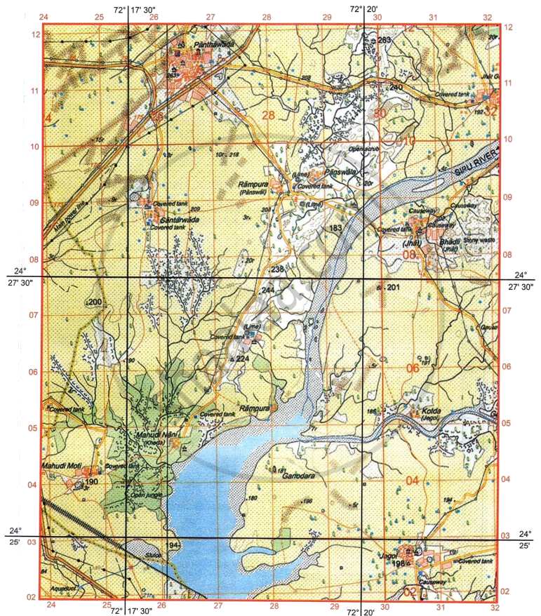
- Give the four figure grid reference of the following:
- A police station.
- Sluice
- What is the nature of Sipu River in its upper section? What is the direction of its flow in the map extract?
- What do the dark brown patches in four figure grid reference 2709 indicate?
- What is the drainage pattern in four figure grids 2806 and in 2807 respectively?
-
- What is the chief reason for the perennial nature of Sipu River to the south of Northing 057
- On which bank of Sipu River is village Rampura located?
- Interpret the following:
- Black straight line with three black dots in between in four figure grid 2411.
- Red broken lines in four figure grid reference 2906.
- Apart from its size, what else makes Panthawada more important settlement than the rest (two reasons only)?
- What is the crow-flying distance in km between triangulated heights 198 and 224?
- List two important occupations of the people living in four figure grid 2706. Give a reason each for your answer.
-
- What is the pattern of settlement at Mahudi Moti?
- Interpret the conventional symbol shown at six figure grid reference 286089?
Austine Vas, Hemant M. Pednekar, Vidhya Malar solutions for जीआग्रफी ऑर अर्थ [अंग्रेजी] कक्षा १० आईसीएसई 1 Interpretation of Topographical Maps Exercise 6 [Page 57]
Study the extract of the Survey of India map sheet no: G43510 - Map 6 and answer the following questions (Eastings 64 to 72 and Northings 29 to 39):
- Interpret the following:
- PF in four figure grid reference 6935.
- Red dotted line in grid reference 7131.
-
- What is the main source of perennial water supply to village Asawa?
- What is the meaning of 300 in grid square 67307?
-
- In which quarter of the map is the occupation of the people forestry?
- Give four figure grid reference of a veterinary hospital.
- What is a fireline? What is the use of fireline in grid square 7130?
-
- What do the black curved lines in four figure grid reference 6631 represent?
- What do they indicate about the rainfall in the region?
- What is the direction of the following:
- Pithapura (6633) from Udwariya (6934).
- On which bank of Sipu River is village Gulabganj located.
- What is the area in kilometre square between Northing 35 to 38 and Easting 68 to 70?
- List one main difference and one similarity between the settlement pattern in four figure gird reference 6535 and the settlement of Gulabganj?
- Which National Highway runs through the surveyed region? How does it cross the intervening Sipu River?
- Identify the drainage pattern in the following grid squares:
- 6736
- 6729
Austine Vas, Hemant M. Pednekar, Vidhya Malar solutions for जीआग्रफी ऑर अर्थ [अंग्रेजी] कक्षा १० आईसीएसई 1 Interpretation of Topographical Maps Exercise 7 [Page 59]
Study the extract of the Survey of India map sheet no: G4357 - Map 7 and answer the following questions (Eastings 38 to 46 and Northings 02 to 12):
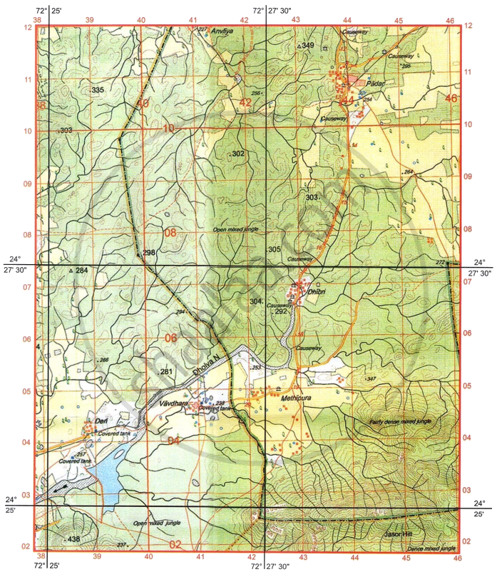
- If you were to cycle at 10 km an hour, how much time would it take to cover the north-south distance depicted on this map?
- Calculate, in metres, the difference in height between the highest spot height on the map extract and the contour height in grid square 3808.
- What do the contour lines represent in grid squares 4304 and 4303?
-
- What are the two types of vegetation shown on the map extract?
- What is the purpose of covered tank in the settlement Vavdhara?
- The surveyed region never receives the vertical rays of the sun. Justify the statement.
- The region is economically not much developed. Justify the statement with two reasons as shown on the map extract.
- Give the four figure grid reference of the following:
- Maximum number of road bridges.
- Largest area covered by a perennial water body.
-
- What is the drainage pattern in grid square 4303?
- What is the direction of Vavdhara from Dhibri?
- Give six-figure grid reference of the following:
- Spot height 438.
- Triangulated height 349.
- What is the area in km2, enclosed by Eastings 38 and 42 and Northings 08 and 11?
Austine Vas, Hemant M. Pednekar, Vidhya Malar solutions for जीआग्रफी ऑर अर्थ [अंग्रेजी] कक्षा १० आईसीएसई 1 Interpretation of Topographical Maps Exercise 8 [Page 61]
Study the extract of the Survey of India map sheet no: G43510 - Map 8 and answer the following questions (Eastings 52 to 60 and Northings 26 to 36):
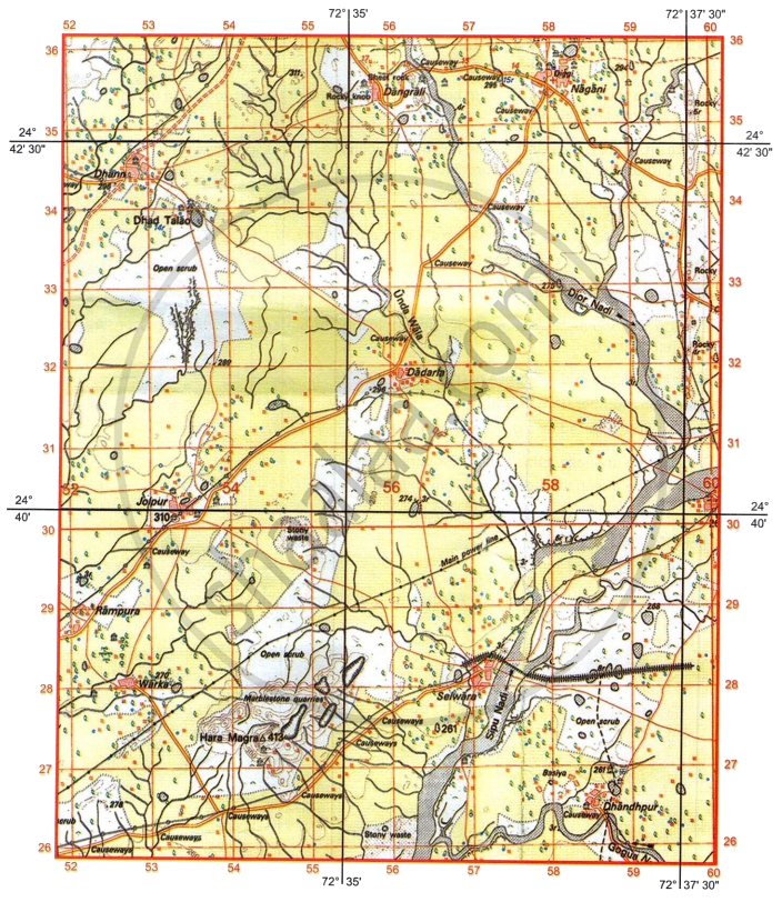
- If a man were to walk from settlement Dhann to Dadarla:
- In which direction would he be walking?
- What kind of road would he be using?
- What is the distance travelled by him (in kilometres) along the road?
-
- How are gentle and steep slopes represented in a topo map?
- What is the meaning of 14 r in four figure grid reference 5333.
- What is the difference in drainage pattern between grid references 5427 and 5434?
- Define Contour interval. What is the contour interval of the map given to you?
- Give the four figure grid reference of the following:
- Largest area under broken ground.
- Confluence of Sipu Nadi and Dior Nadi.
-
- Give two probable reasons other than dry water features, to indicate that the region depicted on the map extract receives seasonal rainfall.
- Give reason - The region between settlement Selwara and grid square 5326 has number of Causeways.
- What is the difference in settlement pattern found at Selwara and in four figure grid reference 5331 respectively?
-
- What is a Diggi (5835)?
- What is a rocky knob (5535)?
- What is the aerial distance in kilometres between the Chhatri at Dhandhpur (5826) to the temple at Dhann (5234)?
Austine Vas, Hemant M. Pednekar, Vidhya Malar solutions for जीआग्रफी ऑर अर्थ [अंग्रेजी] कक्षा १० आईसीएसई 1 Interpretation of Topographical Maps ICSE BOARD EXAMINATION QUESTION AND ANSWERS [Pages 66 - 68]
Study the extract of the Survey of India Map Sheet No: G4357 and answer the following questions:
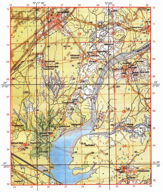
-
- Give the four figure grid reference of Δ 224 [1]
- What is the contour interval used in the given map extract? [1]
-
- Mention two man-made features seen in grid square 2706. [1]
- Mention two natural features seen in grid square 2905. [1]
-
- What do you understand by 1:50000 printed below the map extract? [1]
- What is the pattern of drainage seen in the grid square 2505? [1]
-
- What do you understand by 10 r in 2709? [1]
- What is the compass direction of Mahudi Nani (2604) from Panswala (2909)? [1]
- Calculate the area in kilometre square of the region enclosed between Easting 26 to 29 and Northing 05 to 11? [2]
Study the extract of the Survey of India Map Sheet No: G4357 and answer the following questions:
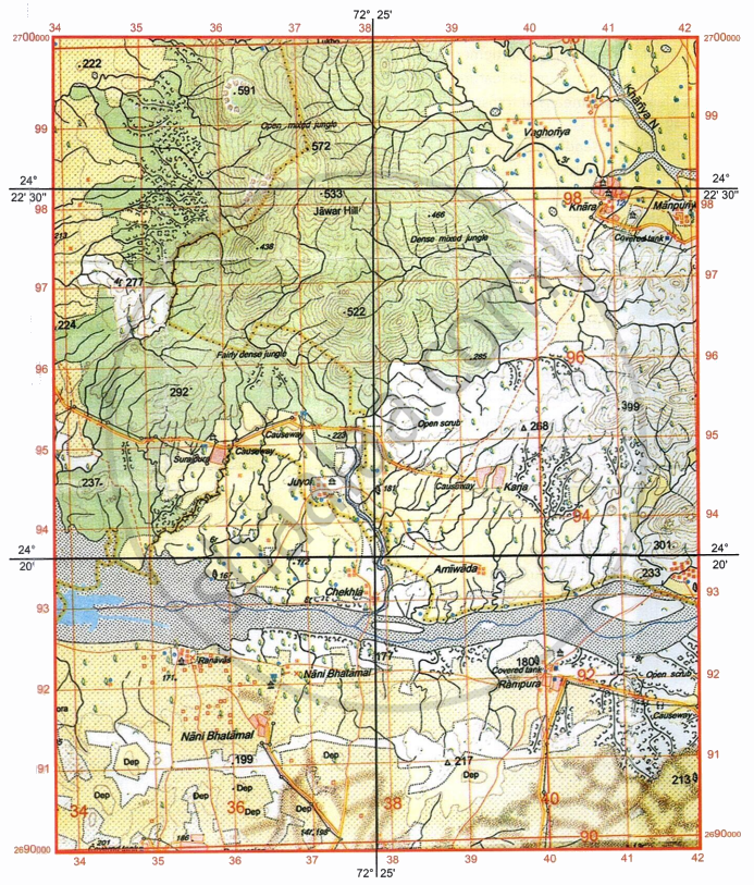
-
- Give the six-figure grid reference for spot height .522 [1]
- What is the pattern of settlement in the grid square 3591? [1]
-
- Mention two man-made features seen in the grid square 3794 [1]
- Mention two means of transport used by the people of Nani Bhatamal in the grid square 3691. [1]
-
- Identify the landform marked by the contours in the grid square 3896. [1]
- What is the pattern of drainage seen in the grid square 3697? [1]
-
- What is the reason for the presence of causeway in the grid square 3695? [1]
- What is the compass direction of Khara (4097) from Karja (3994)? [1]
- Calculate the area in kilometre square of the region to the south of 94 Northing. [2]
Solutions for 1: Interpretation of Topographical Maps
Austine Vas, Hemant M. Pednekar, Vidhya Malar solutions for जीआग्रफी ऑर अर्थ [अंग्रेजी] कक्षा १० आईसीएसई chapter 1 - Interpretation of Topographical Maps
Shaalaa.com has the CISCE Mathematics जीआग्रफी ऑर अर्थ [अंग्रेजी] कक्षा १० आईसीएसई CISCE solutions in a manner that help students grasp basic concepts better and faster. The detailed, step-by-step solutions will help you understand the concepts better and clarify any confusion. Austine Vas, Hemant M. Pednekar, Vidhya Malar solutions for Mathematics जीआग्रफी ऑर अर्थ [अंग्रेजी] कक्षा १० आईसीएसई CISCE 1 (Interpretation of Topographical Maps) include all questions with answers and detailed explanations. This will clear students' doubts about questions and improve their application skills while preparing for board exams.
Further, we at Shaalaa.com provide such solutions so students can prepare for written exams. Austine Vas, Hemant M. Pednekar, Vidhya Malar textbook solutions can be a core help for self-study and provide excellent self-help guidance for students.
Concepts covered in जीआग्रफी ऑर अर्थ [अंग्रेजी] कक्षा १० आईसीएसई chapter 1 Interpretation of Topographical Maps are Elements of a Map, Types of Maps, Various Levels of Topographical Maps Based on Different Scales, Map Scale, Grid Reference, Methods of Representation of Relief on the Map > Hill Shading, Methods of Representation of Relief on the Map > Contours, Relationship Between Physical Features and Human Activities, Analysis of Topo-sheet No. G43S7, Analysis of Topo-sheet No. G43S10, Occupation, Settlement Pattern, Natural Vegetation, Human-Made and Natural Features, Topographic or Ordnance Survey Maps, National Grid Reference, Conventional Signs and Symbols used in Topographical Maps, River Features and Drainage Pattern in a Topographical Map, Representation of Relief Features, Methods of Representation of Relief on the Map > Hachures, Identification of Landforms Marked by Contours, Measurement of Distances on a Map, Means of Irrigation and Other Water Features in a Topographical Map, Direction, Representation of Heights in · Topographical Map, Map Reading, Primary Information or Marginal Information, Contour Diagrams, The Stages of the River, Structure of Topographical Map, Introduction to Topographical Maps and Their Significance, Elements of a Map, Types of Maps, Various Levels of Topographical Maps Based on Different Scales, Map Scale, Grid Reference, Methods of Representation of Relief on the Map > Hill Shading, Methods of Representation of Relief on the Map > Contours, Relationship Between Physical Features and Human Activities, Analysis of Topo-sheet No. G43S7, Analysis of Topo-sheet No. G43S10, Occupation, Settlement Pattern, Natural Vegetation, Human-Made and Natural Features, Topographic or Ordnance Survey Maps, National Grid Reference, Conventional Signs and Symbols used in Topographical Maps, River Features and Drainage Pattern in a Topographical Map, Representation of Relief Features, Methods of Representation of Relief on the Map > Hachures, Identification of Landforms Marked by Contours, Measurement of Distances on a Map, Means of Irrigation and Other Water Features in a Topographical Map, Direction, Representation of Heights in · Topographical Map, Map Reading, Primary Information or Marginal Information, Contour Diagrams, The Stages of the River, Structure of Topographical Map, Introduction to Topographical Maps and Their Significance.
Using Austine Vas, Hemant M. Pednekar, Vidhya Malar जीआग्रफी ऑर अर्थ [अंग्रेजी] कक्षा १० आईसीएसई solutions Interpretation of Topographical Maps exercise by students is an easy way to prepare for the exams, as they involve solutions arranged chapter-wise and also page-wise. The questions involved in Austine Vas, Hemant M. Pednekar, Vidhya Malar Solutions are essential questions that can be asked in the final exam. Maximum CISCE जीआग्रफी ऑर अर्थ [अंग्रेजी] कक्षा १० आईसीएसई students prefer Austine Vas, Hemant M. Pednekar, Vidhya Malar Textbook Solutions to score more in exams.
Get the free view of Chapter 1, Interpretation of Topographical Maps जीआग्रफी ऑर अर्थ [अंग्रेजी] कक्षा १० आईसीएसई additional questions for Mathematics जीआग्रफी ऑर अर्थ [अंग्रेजी] कक्षा १० आईसीएसई CISCE, and you can use Shaalaa.com to keep it handy for your exam preparation.
