Advertisements
Advertisements
प्रश्न
Study the extract of the Survey of India map sheet no: G4357 - Map 7 and answer the following questions (Eastings 38 to 46 and Northings 02 to 12):
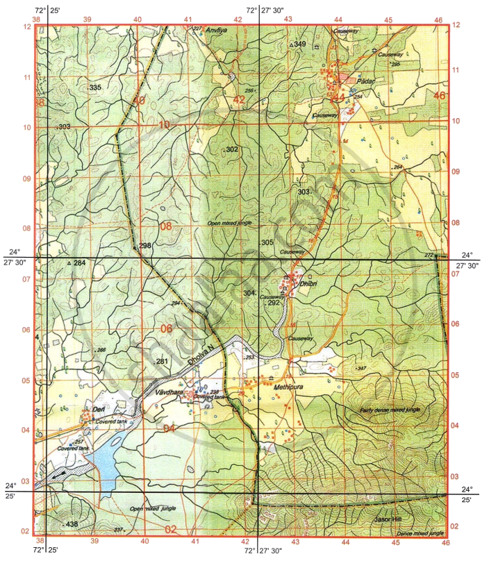
- If you were to cycle at 10 km an hour, how much time would it take to cover the north-south distance depicted on this map?
- Calculate, in metres, the difference in height between the highest spot height on the map extract and the contour height in grid square 3808.
- What do the contour lines represent in grid squares 4304 and 4303?
-
- What are the two types of vegetation shown on the map extract?
- What is the purpose of covered tank in the settlement Vavdhara?
- The surveyed region never receives the vertical rays of the sun. Justify the statement.
- The region is economically not much developed. Justify the statement with two reasons as shown on the map extract.
- Give the four figure grid reference of the following:
- Maximum number of road bridges.
- Largest area covered by a perennial water body.
-
- What is the drainage pattern in grid square 4303?
- What is the direction of Vavdhara from Dhibri?
- Give six-figure grid reference of the following:
- Spot height 438.
- Triangulated height 349.
- What is the area in km2, enclosed by Eastings 38 and 42 and Northings 08 and 11?
कारण बताइए
औचित्य
विस्तार में उत्तर
Advertisements
उत्तर
1. Map scale 2 cm to 1 km.
The north-south distance on the map = 20 cm
Distance on the ground = `(20 "cm")/(2 "cm") xx 1 "km"`
= 10 km
Time taken = `(10 "km")/10 xx 1 "hour"` = 1 hour
Therefore, the north-south distance can be covered in one hour.
2. Highest spot height = 438
Contour height = 240
Difference is 438 − 240 = 198 meters
3. 4304 = gentle slope
4303 = steep slope
4.
- Fairly dense mixed jungle
Open mixed jungle
Open scrub - Covered tanks are used to store potable water. They help to prevent evaporation and pollution of water.
5. The region lies to the north of Tropic of Cancer (23° 30'N latitude).
6. Reasons:
- Most of the region is forested land with hilly topography,
- Transport network, i.e., road network is not much developed in the region.
7.
- 4308 or 4307
- 3903
8.
- Dendritic drainage
- South-West
9.
- 384021
- 431116
10. 12 km2
shaalaa.com
क्या इस प्रश्न या उत्तर में कोई त्रुटि है?
