Advertisements
Advertisements
प्रश्न
Study the extract of the Survey of India map sheet no: G43510 - Map 6 and answer the following questions (Eastings 64 to 72 and Northings 29 to 39):
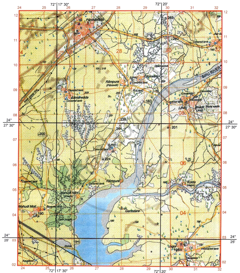
- Interpret the following:
- PF in four figure grid reference 6935.
- Red dotted line in grid reference 7131.
-
- What is the main source of perennial water supply to village Asawa?
- What is the meaning of 300 in grid square 67307?
-
- In which quarter of the map is the occupation of the people forestry?
- Give four figure grid reference of a veterinary hospital.
- What is a fireline? What is the use of fireline in grid square 7130?
-
- What do the black curved lines in four figure grid reference 6631 represent?
- What do they indicate about the rainfall in the region?
- What is the direction of the following:
- Pithapura (6633) from Udwariya (6934).
- On which bank of Sipu River is village Gulabganj located.
- What is the area in kilometre square between Northing 35 to 38 and Easting 68 to 70?
- List one main difference and one similarity between the settlement pattern in four figure gird reference 6535 and the settlement of Gulabganj?
- Which National Highway runs through the surveyed region? How does it cross the intervening Sipu River?
- Identify the drainage pattern in the following grid squares:
- 6736
- 6729
अंतर स्पष्ट करें
समानताएं
विस्तार में उत्तर
Advertisements
उत्तर
-
- Protected forest
- Foot path
-
- Perennial tank in the village.
- It is a contour height 300 metres above mean sea level.
-
- South East
- 6533
- Fireline is a 5-meter clearing made in forests. It is very useful in grid square 7130 to prevent the spread of forest fire as it is a forest area.
-
- Broken ground
- It indicates seasonal rainfall.
-
- South-West
- Left bank
- The area in kilometre square between Northing 35 to 38 and Easting 68 to 70 is 6 km2.
- Difference: 6535 is a dispersed settlementwhereas Gulabganj is a nucleated settlement.
Similarity: Both are permanent settlements. - NH 168. It crosses Sipu River by a bridge.
-
- Dendritic drainage
- Radial drainage
shaalaa.com
क्या इस प्रश्न या उत्तर में कोई त्रुटि है?
