Advertisements
Advertisements
प्रश्न
Give the meanings of the important terms used in toposheets.
Advertisements
उत्तर
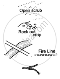
Open Scrub: It is the land where nothing grows. It is a sign of desert area. It indicates occupation as sheep or goat rearing.
Rock Outcrop: It is an exposed part of rock. Cultivation is not possible.
Sheet Rock: It is a mass or slab of rock, a portion of which is exposed above the surface. Shown in white it is also printed so.
Fire Line: A clearing is made in the forest to check the spread of fire.
Causeway: Causeway is a raised road or platform across a minor stream (not to be confused with a bridge). Its presence indicates areas of scanty or seasonal rainfall. Stream having causeway is motorable during dry season.
Broken Ground: It is the weathered part of the land caused due to erosion during heavy rain at the time of flooding. It is found mostly in dry regions around streams and rivers. On toposheet it is shown by tiny curved black line.
Aqueduct: It is a channel through which water flows.
Quarry: It is a pit from which limestone, marble, rock, sand or clay is obtained for building or other purposes.
Lime Kiln: It is a plant for manufacturing lime. Lime is used for making mortar which is used in holding bricks together.
Dry Well: The word ‘dry’ written in brackets near a well denotes a well that is dry in the dry season.
Brackish Well: The word ‘brackish’ written in brackets near a well means that the water in the well has a high salt content and is not fit for drinking. May be used for irrigation.
APPEARS IN
संबंधित प्रश्न
Name two natural features in 0527.
Study the extract of the Survey of India Map sheet No. 45D/10 and answer the following questions:

-
- Give the six-figure grid reference for the temple that is located to the southwest of Pithapura settlement. (1)
- Give the four-figure grid reference for a settlement where people of the region meet socially and for trade at least once in year. (1)
-
- What is the pattern of drainage seen in the grid square 2118? (1)
- What is the pattern of settlement seen in the grid square 1923? (1)
- What do each of the two numbers (281 printed in black colour and 20 printed in red colour) in the grid square 1818 indicate? (2)
-
- Name any two man-made features in grid square 2419. (1)
- Name any two natural features in grid square 2118. (1)
- What is the significance of the following?
- Fire line in grid square 2417. (1)
- Water body found in grid square 2221. (1)
- Calculate the area of the region between 16 and 19 Eastings and 18 and 22 Northings. Give your answer in square kilometers. (2)
- Give a reason for each of the following:
- The water in some of the wells in the north-west quarter of the map is not fit for drinking. (1)
- The region near Anadra and Gulabgani has many causeways. (1)
-
- What is the main means of irrigation used by people living in the area shown on the map? (1)
- What is the main occupation of the people of the region shown on the map? (1)
- Which, according to you, is the most important settlement? Give a reason to support your answer. (2)
- Name any two means of transport used by the people living in the area shown on the map extract. (2)
What do you understand by the term Grid?
The area is measured by grid square method?
What is a Nodal centre?
(i) What is the importance of a Relief Map.
(ii) How can we show occupations by the evidences of names or by inference of relief features?
Name the various types of settlement patterns found on toposheet.
Study the extract of the Survey of India Map sheet No. 45D/10 and answer the following questions:
(a)
(i) Give the four figure grid reference of the settlement of Hamirpura.
(ii) Give the six figure grid reference of the temple in the settlement of Jolpur.
(b)
(i) What does the blue coloured circle in the grid square 0619 represent?
(ii) What is the compass direction of Dantrai from Jolpur?
(c) What is the difference between the:
(i) Pattern of settlements in 0725 and the settlement of Idarla?
(ii) Drainage pattern of the streams in 0624 and those in 0824?
(d)
(i) What is the value of the contour line in square 0226?
(ii) What is the contour interval in the map?
(e) Mention any two factors which provide evidence that the region in the map extract is a rural region.
(f)
(i) How does the feature, indicated by the black curves in 0721, show that rainfall in this region is seasonal?
(ii) Mention one man-made feature in the map which also provides evidence that the rainfall is seasonal.
(g)
(i) Name two natural features in 0527.
(ii) Name two manmade features in 0325.
(h) Name two features which make Dantrai a more important settlement than the other settlements in the map extract.
(i) Calculate the area of the region which lies to the south of northing 21 in square kilometres.
(j) What are the following?
(i) The black vertical line between eastings 09 and 10.
(ii) 302 in grid square 0425.
Answer the following questions on the Survey Sheet Number 45 D/10. Eastings 00 to 10; Northings 17 to 28. (Map G)
(a) Give four-figure grid references of the following:
(i) Dhad Talao (ii) Sheet rock in the North-east
(iii) Rock outcrop in the North (iv) Stony waste in the South-east
(v) Open scrub south of Dhad Talao
(b) Give the six-figure grid references of the following:
(i) Police Chowki in village Dantral
(ii) Temple in Bhamra village
(iii) Well with water in settlement Devka
(iv) Spot height 310 near village Jolpur
(v) Tank near Indaria settlement
(c) Give-the direction of the following:
(i) Village Dantral (0324) from Dhann (0723)
(ii) Village Bhamra (0521) from Dhann (0723)
(iii) Village Jolpur (0718) from Malawa (0519)
(iv) Village Warka (0716) from Bikanwas (0316)
(v) Village Rampura (0617) from Dhann (0723)
(d) Give the meanings of the following:
(i) 15r in blue in grid square 0224.
(ii) 300 in brown in grid square 0426.
(iii) Black line in the northernmost part of the map.
(iv) Red line in grid square 0819.
(v) Black dots in grid square 0617.
(e) Give the settlement patterns of the following:
(i) Village Dhann (ii) In grid square 0220
(f) Measure the distances of the following:
(i) Direct distance in km. from Indaria (0826) to Jolpur (0718)
(ii) Indirect distance in km. along the cart track from Dantral (0324) to Dhann (0723)
(g) Give the drainage patterns of the following:
(i) 0827 (ii) In grid square 0226
(h) Name three man-made features found in grid square 0419 and draw their symbols.
(i) Give two evidences that the region gets seasonal rainfall.
(j) Explain the nature of the river.
(k) Explain the relief of the area.
(l) What is the general slope of the land? Give reason for your answer.
(m) What is the main occupation of the people? Give reason for your answer.
(n) What is the mode of irrigation? Give reasons for your answer.
(o) What is the mode of transport? Give reasons for your answer.
If you are interpreting the cultural features from a topographical sheet, what information would you like to seek and how would you derive this information? Discuss with the help of suitable examples.
